Mount Macedon facts for kids
Quick facts for kids Mount Macedon(Geboor) |
|
|---|---|

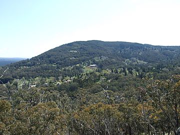
Mount Macedon, above the town of Mount Macedon.
|
|
| Highest point | |
| Elevation | 1,001 metres (3,284 ft) |
| Prominence | 643 metres (2,110 ft) |
| Parent peak | Camel's Hump or Camels Hump |
| Geography | |
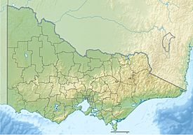
| Location | Central Highlands, Victoria, Australia |
| Parent range | Macedon Ranges, Great Dividing Range |
| Climbing | |
| First ascent | Thomas Mitchell (European: 1836) |
Mount Macedon, known as Geboor or Geburrh by the local Wurundjeri Aboriginal people, is a dormant volcano in Victoria, Australia. It's part of the Macedon Ranges, which belong to the much larger Great Dividing Range. This mountain stands about 1,001 meters (3,284 feet) high and is located roughly 65 kilometers (40 miles) northwest of Melbourne. It's a popular place for people to visit and enjoy nature.
Contents
About Mount Macedon
What's in a Name?
The Wurundjeri people, who are the traditional owners of this land, call the mountain Geboor or Geburrh in their Woiwurrung language.
In 1824, explorers Hamilton Hume and William Hovell saw the mountain and named it Mount Wentworth. Later, in 1836, another explorer named Major Thomas Mitchell climbed the mountain. He renamed it Mount Macedon after Philip II of Macedon, an ancient king. Mitchell chose this name because he could see Port Phillip Bay from the top of the mountain. He also named other places nearby after figures from Ancient Macedonia, like the Campaspe River and Mount Alexander.
A Look Back in Time
At the bottom of Mount Macedon, there's an important historical site for the Wurundjeri people. It's a large sandstone rock with 31 grooves. These grooves were made by people sharpening their stone axes long ago. This site shows how the land was used and valued by Aboriginal communities for many years.
Exploring the Summit
Camel's Hump: The Highest Point
The very highest part of Mount Macedon is called Camel's Hump. It's a rocky outcrop that was once a small, steep-sided volcano. Camel's Hump is about 1,011 meters (3,317 feet) high and sometimes gets covered in snow during winter. This rocky area, along with Hanging Rock and Croziers Rocks, is made of a type of volcanic rock called trachyte. These rocky cliffs are popular with rock climbers. Because it's close to Melbourne, the mountain is a favorite spot for both climbing and family outings.
From the top of Mount Macedon, you can see amazing views. On a clear day, you might spot the city of Melbourne, the Dandenong Ranges, and even the You Yangs mountains near Geelong.
The Mount Macedon Memorial Cross
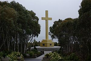
Near the summit of Mount Macedon, there's a huge monument called the Mount Macedon Memorial Cross. It stands 21 meters (69 feet) tall in an area known as Cross Reserve. This cross was built in 1935 by William Cameron, who lived in the town of Mount Macedon. He created it to remember his son and all the other people who died in World War I.
Weather and Nature
Mount Macedon gets a lot of rain, usually about 1,000 millimeters (39 inches) each year. Most of the rain falls in winter, with less rain during the summer months from January to March. It snows on the mountain about 15 to 20 days a year, and the snow stays on the ground for 10 to 15 days.
The area often experiences severe frost, especially between May and September. Even during other times of the year, light frosts can occur. The coldest temperatures recorded have been around -9°C (16°F). In winter, you might also see "black ice," which is a thin, clear layer of ice that's hard to spot on roads.
Interesting Events
On November 8, 1948, a Douglas DC-3 airplane from Australian National Airways crashed on Mount Macedon. This happened just a few minutes after it took off from Essendon Airport. Sadly, the pilot and co-pilot died. However, the cabin crew and all 19 passengers survived with only minor injuries. A special plaque in Cross Reserve remembers this event.
 | Tommie Smith |
 | Simone Manuel |
 | Shani Davis |
 | Simone Biles |
 | Alice Coachman |


