Cunninghams Gap facts for kids
Quick facts for kids Cunninghams Gap |
|
|---|---|
| Cappoong | |

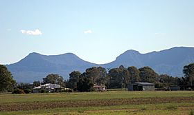
View from Kents Lagoon, 2015
|
|
| Elevation | 787 metres |
| Traversed by | Allan Cunningham |
| Location | Tarome, South East Queensland, Queensland |
| Range | Main Range |
Cunninghams Gap is a mountain pass in Queensland, Australia. It crosses the Great Dividing Range, a long chain of mountains. This pass connects the Darling Downs area with the Fassifern Valley.
It's a really important route along the Main Range. This pass helps people travel between the towns of Warwick and Brisbane. The Cunningham Highway was built right through this gap to make travel easier.
You can find Cunninghams Gap inside Main Range National Park. It sits between two peaks called Mount Cordeaux and Mount Mitchell. On a clear day, if you look from Brisbane, you can see a clear break in the mountains where the pass is. It's located in Tregony, right next to Tarome.
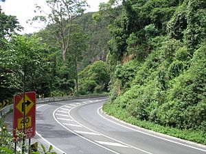
The highway itself offers amazing views. But be careful, it's quite steep, with an 8-degree slope when you go down!
The Story of Cunninghams Gap
What's in a Name?
The local Indigenous people have their own name for this place: Cappoong. We don't know exactly what this name means.
There's a cool legend from the dreamtime about how the gap was formed. The Yuggera people gathered all the kangaroos in the area. They fenced them into a valley to stop other tribes from catching them. But an old woman let them all go! As the kangaroos ran across the Great Dividing Range, they created the gap between Mount Mitchell (which they called Coonyin-nirra) and Mount Cordeaux (called Niamboyoo).
Early Explorers and the Road
In 1827, a botanist named Allan Cunningham explored west of the Dividing Range, discovering the Darling Downs. He returned in 1828 from Brisbane to explore Cunninghams Gap. He knew how important it would be to connect the coast with the farming lands to the west. Cunningham traveled on the right side of the gap, but today's highway goes on the left side from Aratula.
On July 3, 1909, Cunninghams Gap was officially made a national park. This new park was about 3,100 acres and included Gap Creek. Walking paths were built there in the 1930s and 1950s.
On June 11, 1927, exactly 100 years after Allan Cunningham explored the Darling Downs, a new road through Cunninghams Gap was opened. A local politician, Sir Littleton Groom, officially opened it. This road was built entirely by volunteers! However, it wasn't really ready for travel, especially the part west of Aratula. Less than a month after it opened, the Royal Automobile Club of Queensland announced that the road was closed because of problems. The fully sealed (paved) road through the gap finally opened in November 1949.
Modern Times
Cunninghams Gap is now part of the Cunningham Highway. This highway gets money from the government and is managed by the Queensland Department of Transport and Main Roads.
Between December 2010 and March 2011, the gap had over two meters of rain! This caused a lot of damage to the road. It cost about $40 million to fix this seven-kilometer stretch of highway. The Department of Transport and Main Roads worked with an engineering company called Coffey to repair it.
 | Claudette Colvin |
 | Myrlie Evers-Williams |
 | Alberta Odell Jones |


