
Aratula facts for kids
Quick facts for kids AratulaQueensland |
|||||||||||||||
|---|---|---|---|---|---|---|---|---|---|---|---|---|---|---|---|

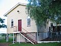
St Stephen's Anglican church
|
|||||||||||||||

Aratula
Location in Queensland
|
|||||||||||||||
| Population | 609 (2021 census) | ||||||||||||||
| • Density | 23.24/km2 (60.2/sq mi) | ||||||||||||||
| Postcode(s) | 4309 | ||||||||||||||
| Area | 26.2 km2 (10.1 sq mi) | ||||||||||||||
| Time zone | AEST (UTC+10:00) | ||||||||||||||
| Location |
|
||||||||||||||
| LGA(s) | Scenic Rim Region | ||||||||||||||
| State electorate(s) | Scenic Rim | ||||||||||||||
| Federal Division(s) | Blair | ||||||||||||||
|
|||||||||||||||
Aratula is a small country town in Queensland, Australia. It's part of the beautiful Scenic Rim Region. In 2021, about 609 people lived in Aratula.
Contents
Where is Aratula?
Aratula is located about 52 kilometers (32 miles) southwest of Ipswich. The main road, called the Cunningham Highway, goes right through the town. It enters from the northeast and leaves towards the south.
A creek named Warrill Creek flows through the northern part of Aratula. This creek eventually joins the Bremer River, then the Brisbane River, and finally flows into Moreton Bay.
A Look Back: Aratula's History

Aratula was first known as Carter's Gate. Later, its name was changed to Aratula, matching the local railway station.
Schools and Churches
Carter's Gate Provisional School opened in 1911. It became Aratula State School in 1913. Sadly, the school building burned down in 1916. The fire was thought to be suspicious. The school celebrated its 100th birthday in May 2011.

St Pauls Lutheran Church opened in 1913. It closed its doors in 1997, but the building still stands today. There's also a Lutheran cemetery behind the church.
The Aratula Baptist Church started in 1923. It was located near the Cunningham Highway. In 1972, the church building was moved to Kalbar to be used as a church hall.
Railway and Post Office
A railway line reached Aratula in 1922. The Aratula railway station was located on Sawmill Road. However, the railway line closed in 1960.
Aratula also had a Post Office, which opened around 1925. It closed in 1987.
The School of Arts

The Aratula School of Arts officially opened in 1926. This building was a community hub for local events and learning. It was located on Elizabeth Street. The building was sold to a private owner in 2013.
St Stephen the Martyr Anglican Church was officially opened in 1954. It is still an important part of the community today.
Who Lives in Aratula?
In 2011, Aratula had a population of 505 people. By 2016, this number grew slightly to 532 people. In 2021, the population reached 609 people.
Special Places in Aratula
Aratula has some places that are important for their history. One of these is St Stephen's Anglican Church, located at 25 Elizabeth Street.
Learning in Aratula
Aratula State School is a primary school for students from Prep to Year 6. It's located at 41 Elizabeth Street. In 2017, the school had 44 students.
There are no high schools in Aratula. The closest high school is Boonah State High School in Boonah.
What to Do in Aratula

St Stephens the Martyr Anglican Church is located at 25 Elizabeth Street.
Aratula is a great place for travelers to stop and rest. It's often used by people driving across the Great Dividing Range. You can find a caravan park and a hotel right off the highway.
Nearby attractions include:
- Moogerah Peaks National Park
- Main Range National Park
- Lake Moogerah
- You can even go hot air ballooning in the area!
Images for kids
-
Kalbar Baptist Hall, which used to be the Aratula Baptist Church
,_2005.jpg)
