Lockyer Creek facts for kids
Quick facts for kids Lockyer |
|
|---|---|
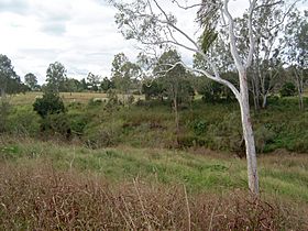
Lower Lockyer Creek, 2011
|
|
|
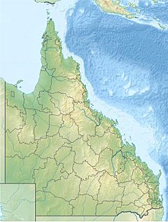
Location of the Lockyer Creek mouth in Queensland
|
|
| Country | Australia |
| State | Queensland |
| Region | South East Queensland |
| Cities | Helidon, Grantham, Gatton |
| Physical characteristics | |
| Main source | Great Dividing Range Main Range National Park 216 m (709 ft) 27°28′6″S 152°5′19″E / 27.46833°S 152.08861°E |
| River mouth | confluence with the Brisbane River near Wivenhoe Pocket 37 m (121 ft) 27°24′59″S 152°36′20″E / 27.41639°S 152.60556°E |
| Length | 113 km (70 mi) |
| Basin features | |
| River system | Brisbane River |
| Basin size | 3,032 km2 (1,171 sq mi) |
| Tributaries |
|
| National park | Main Range National Park |
The Lockyer Creek is a stream in South East Queensland, Australia. It is a major tributary (a smaller stream that flows into a larger one) of the Brisbane River. The creek is very important for the Lockyer Valley area.
It starts high up on the eastern side of the Great Dividing Range. The creek then flows mostly northeast for over 100 kilometers. Finally, it joins the Brisbane River near Lowood, which is downstream from the Wivenhoe Dam. The creek is named after a person called Edmund Lockyer.
Contents
Where Does Lockyer Creek Flow?
The Lockyer Creek begins in the Main Range National Park. This park is a small part of the Great Dividing Range. Many smaller streams flow into Lockyer Creek. These streams drain water from areas east of Toowoomba and north of Gatton. The entire network of Lockyer Creek and its smaller streams stretches for 6,056 kilometers.
The total catchment area (the land where all the water flows into the creek) is 3,032 square kilometers. This is almost a quarter of the entire Brisbane River catchment area. O'Reillys Weir is a small dam about 1 kilometer upstream from where the creek meets the Brisbane River. The Wivenhoe Dam is about 5 kilometers upstream from this meeting point.
Many smaller creeks flow into Lockyer Creek. These include Flagstone Creek, Sandy Creek, Alice Creek, Laidley Creek, Tenthill Creek, Murphys Creek, and Ma Ma Creek.
Environment and Water
Much of the lower part of the Lockyer Creek area has been cleared for farming. However, the upper parts of the creek's catchment still have many forests. Some of these forests are protected in Lockyer National Park.
Managing bushfires, protecting the soil, keeping water clean, and controlling floods are big challenges for this waterway. Sadly, the creek is not in very good condition. This is partly because plants along the creek banks have been removed. This removal has caused the banks to become unstable and led to gully erosion (where water carves out channels in the soil).
There are nine main water storage areas in this creek system. These include Atkinson Dam, Bill Gunn Dam, and Lake Clarendon. The Lockyer Creek valley has been one of the driest areas in Queensland during recent droughts.
Big Floods in the Past
During the 2011 Queensland floods, Lockyer Creek experienced very bad flash flooding. This happened on January 10 and 11 from heavy rain overnight and during the day. The creek reached a depth of 18 meters, which was a record. This was even higher than the flood levels seen in the 1974 Brisbane flood.
The Bureau of Meteorology first thought their equipment was broken. It showed the water level rose 8 meters in just 23 minutes during the flash flood! It's estimated that 4,000 tonnes of water flowed through Lockyer Creek every second. People described it as a "wall of water" or even an "inland tsunami." The water rose about 9 feet (2.7 meters) higher than the 1893 flood level at the Lockyer Creek Railway bridge. Many homes were destroyed, and 19 people sadly died in these floods. The town of Grantham was especially hard hit.
A report suggested that building more flood-controlling dams on Lockyer Creek and the Bremer River could help protect Brisbane from future floods.
Bridges Over the Creek
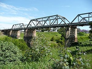
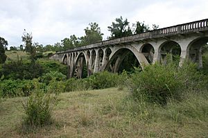
The Lockyer Creek Bridge at Bageli Park is a very important bridge. It was designed by William Pagan and built in 1910-1911. It is one of the largest of its kind in Queensland and one of Australia's first reinforced concrete arch rail bridges. The bridge has three sections, each supported by two arches. It was even featured on a stamp! This bridge is still used today for very heavy trains carrying coal and grain to Brisbane.
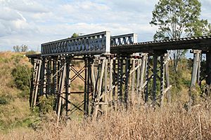
Another single-arch bridge on the same railway line, but over a side gully, is closer to Gatton. It was built earlier, in 1903. Further downstream, in the Clarendon area, there's an even older railway bridge from 1885. This one is made of timber and iron, but it is no longer used by trains.
Heritage Sites
Lockyer Creek has several sites that are listed as important heritage locations:
- Toowoomba – Helidon Line: Lockyer Creek Railway Bridge (Lockyer)
- Toowoomba – Helidon Line: Lockyer Creek Railway Bridge (Murphys Creek)
- Brisbane Valley railway line: Lockyer Creek Railway Bridge (Clarendon)
 | Charles R. Drew |
 | Benjamin Banneker |
 | Jane C. Wright |
 | Roger Arliner Young |


