
Wivenhoe Dam facts for kids
Quick facts for kids Wivenhoe Dam |
|
|---|---|

The Wivenhoe Dam wall and spillway
|
|

Location of the Wivenhoe Dam in Queensland
|
|
| Country | Australia |
| Location | South East Queensland |
| Coordinates | 27°23′38″S 152°36′28″E / 27.39389°S 152.60778°E |
| Purpose |
|
| Status | Operational |
| Construction began | March 1973 |
| Opening date | 1984 |
| Operator(s) | SEQ Water |
| Dam and spillways | |
| Type of dam | Embankment dam |
| Impounds | Brisbane River |
| Height | 59 m (194 ft) |
| Height (thalweg) | 23 m (75 ft) AHD |
| Length | 2,300 m (7,500 ft) |
| Elevation at crest | 79 m (259 ft) AHD |
| Dam volume | 4,140×103 m3 (146×106 cu ft) |
| Spillways | 2 |
| Spillway type |
|
| Spillway capacity | 12,000 m3/s (420,000 cu ft/s) |
| Reservoir | |
| Creates | Wivenhoe Reservoir |
| Total capacity | 1,165,238 ML (256,317×106 imp gal; 307,823×106 US gal) |
| Catchment area | 7,020 km2 (2,710 sq mi) |
| Surface area | 109.4 km2 (42.2 sq mi) |
| Power station | |
| Name | Wivenhoe Power Station |
| Operator(s) | Tarong Energy |
| Commission date | May 1984 |
| Type | Pumped-storage |
| Turbines | 2 |
| Installed capacity | 500 MW (670,000 hp) |
The Wivenhoe Dam is a large dam built across the Brisbane River in South East Queensland, Australia. It's about 80 kilometers (50 miles) from the center of Brisbane. This dam is super important for the region.
Its main job is to provide clean drinking water for Brisbane and Ipswich. But it does much more! It also helps control floods, generates electricity, and offers a fun place for recreation. The huge lake behind the dam is called Lake Wivenhoe.
The idea for Wivenhoe Dam started in the early 1970s. A big flood in Brisbane in 1974 showed everyone how much a dam was needed to protect the area. Lake Wivenhoe also helps power the Wivenhoe Power Station.
Contents
Dam Structure and Features
The Wivenhoe Dam is made of earth and rock. It stands 59 meters (194 feet) high and stretches 2,300 meters (7,500 feet) long. This massive wall holds back Lake Wivenhoe, which can store an amazing 1,165,000 megaliters of water when full.
The dam collects water from a huge area called a catchment area, which is about 7,020 square kilometers (2,710 square miles). This area includes parts of the D'Aguilar National Park. Lake Wivenhoe itself covers 109.4 square kilometers (42.2 square miles).
The dam has a special part called a spillway with five large steel gates. These gates can open to release water safely. There's also an extra "auxiliary spillway" to help prevent the dam from overflowing during extreme floods. SEQ Water has been in charge of managing the dam since 2008.
Building the Dam

People first thought about building a dam here way back in the 1890s. Serious plans began in the mid-1960s. The government finally approved its construction in 1971. Work started in 1973, and the dam was completed by 1985.
Building the dam was a huge project. It cost about A$450 million for the hydro-electric part alone. In 1983, even before it was fully finished, the dam helped prevent a very bad flood in Brisbane. It stopped water that could have caused as much damage as the big flood in 1893.
To make space for the dam, 200 properties were bought. The dam is incredibly large. It can hold twice as much water as Sydney Harbour and about seven times more than the Hinze Dam on the Gold Coast. Wivenhoe Dam even helps supply water to the Gold Coast.
Why Wivenhoe Dam is Important

Wivenhoe Dam was built to solve several important problems. It provides a safe water supply for millions of people. It also protects cities from floods and helps generate electricity.
Controlling Floods

One of the dam's main jobs is to control floods. During a flood, the dam can hold back an extra 1.45 million megaliters of water. This is like adding 225% more capacity just for flood protection! There are strict rules about how and when water must be released from the dam after it reaches full capacity.
Between 2004 and 2008, an extra spillway was added to the dam. This "auxiliary spillway" helps even more to prevent flooding. It has special sections designed to break away if water levels get too high, allowing more water to flow out safely.
The 2011 Queensland Floods
The biggest amount of water ever recorded flowing into the dam happened in January 2011. On January 11, 2011, Wivenhoe Dam reached its highest level ever, holding 191% of its normal water supply capacity. This showed how well it held back floodwaters.
The dam is designed so that water should not flow over its main wall. If it did, it could damage the dam. To prevent this, the dam has its second emergency spillway. During the peak of the 2011 flood, the water level came very close to this emergency spillway, but it did not go over.
Fun Activities at Lake Wivenhoe
Lake Wivenhoe is a popular spot for camping and outdoor fun. You can find camping areas at Captain Logan and Lumley Hill. These spots have hot showers, barbecues, and toilets. There are also playgrounds and a boat ramp at Logan Inlet. Cormorant Bay, Hamon Cove, and Spillway Common are great places for picnics.
If you like to fish, you'll need a special permit to fish in the dam. Swimming is allowed, and you can even go boating with electric or non-powered boats if you have a permit. However, pets are not allowed at the dam.
Amazing Animals in the Dam
The dam is home to the Australian lungfish, a special type of fish that is considered vulnerable. Scientists believe there were about 800 lungfish in the dam in 2010. Sometimes, when the spillway opens, many lungfish are swept out.
Lungfish have lived in dams in South East Queensland for over 100 years. They were originally found only in the Mary and Burnett river systems. But to help protect them, they were moved to other rivers and dams, including the Brisbane River, back in 1895–1896. This helped the species survive and thrive in new places.
Images for kids
-
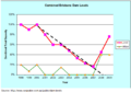
Brisbane combined Dam levels during the 2000-2007 drought.

