
Mary River (Queensland) facts for kids
Quick facts for kids Mary |
|
|---|---|

The upper Mary River at Conondale
|
|

Location of Mary River mouth in Queensland
|
|
| Native name | Moocooboola |
| Other name(s) | Wide Bay |
| Country | Australia |
| State | Queensland |
| Regions | South East Queensland, Wide Bay–Burnett |
| Physical characteristics | |
| Main source | Conondale Range Conondale, South East Queensland 209 m (686 ft) 26°47′39″S 152°44′41″E / 26.79417°S 152.74472°E |
| River mouth | Great Sandy Strait River Heads, Wide Bay–Burnett 0 m (0 ft) 26°35′06″S 152°44′01″E / 26.58500°S 152.73361°E |
| Length | 291 km (181 mi) |
| Basin features | |
| Basin size | 9,595 km2 (3,705 sq mi) |
| Tributaries |
|
| Reservoir | Lake Borumba |

The Mary River is an important river system in Queensland, Australia. It flows through the South East and Wide Bay–Burnett regions. The local Indigenous people, the Kabi people, traditionally called it Moocooboola.
Contents
River's Name: Where it Came From
The Kabi people originally named the river Moocooboola. In 1842, early European explorers Andrew Petrie and Henry Stuart Russell called it the Wide Bay River. The name was officially changed to Mary River in 1847. This was done by Charles Augustus FitzRoy, who was the Governor of New South Wales at the time. He named it after his wife, Lady Mary Lennox.
Mary River's Past
In the early days of European settlement, the Mary River was used to float timber downstream. When gold was found in Gympie in 1867, many miners and farmers moved to the area. The flat areas along the river were used for growing crops. Small-scale dairy farming also began in the 1880s.
River's Path and Features


The Mary River starts in a place called Booroobin, which is in the Sunshine Coast hinterland. It flows north through towns like Kenilworth, Gympie, Tiaro, and Maryborough. Finally, it empties into the Great Sandy Strait, which is a waterway between the mainland and Fraser Island. This area is close to River Heads, about 17 km (11 mi) south of Hervey Bay. The Great Sandy Strait is important because it has wetlands that are recognized internationally by the Ramsar Convention. It is also part of the UNESCO Fraser Island World Heritage Area, which attracts many visitors.
Important bridges over the river include the Dickabram Bridge, the Granville Bridge in Maryborough, and the Lamington Bridge. The Mary River is joined by 19 smaller rivers and streams, called tributaries. Some of these include Tinana Creek, Munna Creek, Obi Obi Creek, and the Susan River. The river drops 209 m (686 ft) over its 291 km (181 mi) course. The area of land that drains into the Mary River, called its catchment area, is 9,595 square kilometres (3,705 sq mi). This area is surrounded by the Conondale, Jimna, and Burnett mountain ranges.
There are only two main structures on the Mary River itself: the Gympie weir and a barrage at Mungar. However, there are several dams on its tributaries. These include Borumba Dam on Yabba Creek, Baroon Pocket Dam on Obi Obi Creek, and Six Mile Creek Dam on Six Mile Creek. There are also two weirs and a barrage on Tinana Creek. Historically, gold was first found in the Mary River at Gympie by James Nash.
Floods in 2011
The Mary River had very big floods during the 2010–2011 Queensland floods. In some places, the river rose by 20 m (66 ft). In Maryborough, the river reached 8.2 m (27 ft), and in Gympie, it peaked at 19.3 m (63 ft). The main highway, the Bruce Highway, was closed north and south of Gympie. More than 50 homes and businesses were flooded. The very muddy water from the floods affected how some river animals naturally breed.
Amazing Animals of the Mary River
The Mary River is home to many unique and special animals. One very rare animal is the endangered Mary River turtle (Elusor macrurus). This turtle is special because it can breathe underwater using its tail! Other important animals in the river include the Queensland lungfish (Neoceratodus forsteri) and the endangered Mary River cod (Maccullochella mariensis).
Many other vulnerable and endangered species also live here:
- The endangered giant barred frog
- The Cascade tree frog
- Coxen's fig parrot
- The vulnerable tusked frog
- The honey blue-eye fish
- The Richmond birdwing butterfly
- The Illidge's ant blue butterfly
Sometimes, Saltwater crocodiles are seen in the lower parts of the river. One large 3.5 m (11 ft) crocodile has been known to live in the river since 2012. Even though the official area for saltwater crocodiles usually ends near Gladstone, the Mary River is considered the southernmost place where they are found.
Protecting the Mary River: The Traveston Crossing Dam Story
In 2006, the Queensland Government planned to build a dam on the Mary River at Traveston Crossing. This plan came after the region had its longest drought in 100 years. The dam was meant to create a large water storage area. However, the project was cancelled in November 2009 by the Federal Environment Minister, Peter Garrett.
There was a lot of opposition to the dam because it would have flooded a large area of farmland and small towns. It would also have affected important natural areas and animal homes. Many local people and councils were against the dam. They worried about:
- People having to leave their homes in the flooded area.
- Bad effects on communities further down the river.
- Damage to the environment.
More than 20,000 people signed a petition asking the Queensland State Parliament to stop the dam. There were also concerns that the ground at the dam site was too sandy, which could lead to water leaking and evaporating.
The wider community and international groups also strongly opposed the dam due to environmental concerns. They were worried about many endangered and vulnerable species that live in the Mary River, including:
- The Mary River cod
- The Mary River turtle
- The giant barred frog
- The Cascade tree frog
- Coxen's fig parrot
- The Queensland lungfish
- The tusked frog
- The honey blue-eye fish
- The Richmond birdwing butterfly
- The Illidge's ant blue butterfly
There were also fears for the dugong, a globally vulnerable sea mammal. It was thought that less fresh water flowing into the Great Sandy Strait would harm the seagrass, which is the dugong's main food.
The Mary River Turtle and the Queensland Lungfish received special attention for their protection. The Mary River Turtle is only found in the Mary River. It is one of the top 25 most endangered turtle species in the world. The Lungfish is very important to scientists who study evolution. It needs fast-flowing water (rapids) to breed. Many of its breeding areas had already been affected by other dams. Experts believed the dam would push the lungfish closer to extinction. The Mary River Cod, which naturally lives only in the Mary River system, is already critically endangered and fully protected.
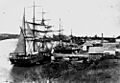
Maryborough's Port History
The Port of Maryborough opened in 1847 and became an official port for ships in 1859. After the river became too shallow for larger ships, a new town and port were built. From the 1850s to the end of the century, this port was one of Australia's busiest for people arriving from other countries. Some officials still called it "Wide Bay" port even into the 1860s.
Images for kids
-
The barque Maria Ysasi, 1874
.jpg)
See also
 In Spanish: Río Mary para niños
