Conondale, Queensland facts for kids
Quick facts for kids ConondaleQueensland |
|||||||||||||||
|---|---|---|---|---|---|---|---|---|---|---|---|---|---|---|---|

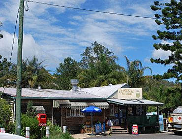
Conondale General store
|
|||||||||||||||
| Population | 882 (2021 census) | ||||||||||||||
| • Density | 5.179/km2 (13.41/sq mi) | ||||||||||||||
| Postcode(s) | 4552 | ||||||||||||||
| Area | 170.3 km2 (65.8 sq mi) | ||||||||||||||
| Time zone | AEST (UTC+10:00) | ||||||||||||||
| Location | |||||||||||||||
| LGA(s) | Sunshine Coast Region | ||||||||||||||
| State electorate(s) | Glass House | ||||||||||||||
| Federal Division(s) | Fisher | ||||||||||||||
|
|||||||||||||||
Conondale is a small country town in the Sunshine Coast Region of Queensland, Australia. It's known as a rural locality (a specific area or place). In 2021, about 882 people lived in Conondale.
Contents
Where is Conondale?
Conondale is located in the beautiful Sunshine Coast hinterland. This means it's in the area behind the coastal beaches. The town sits right on the banks of the upper Mary River. It is about 114 kilometers (71 miles) north of Brisbane, the capital city of Queensland.
A Look Back in Time
How Conondale Got Its Name
The name Conondale comes from a large farm, or "pastoral run," started in 1851. A man named Donald Tuach McKenzie named it Conondale. He chose this name because it reminded him of the Conon River in Ross and Cromarty, Scotland, where he was born.
Early Plans for a Dairy Town
In 1906, a big part of the Conondale farm was put up for sale. It was advertised as 14,000 acres of great land for farming and dairying. The people selling the land even built a butter factory as part of the deal! They hoped it would help the area grow. However, the butter factory never actually opened. The building was later taken apart, and its wood was used to build a house somewhere else.
Conondale Schools Over the Years
Conondale has had schools for a long time.
- In September 1912, two schools opened: Conondale Provisional School and Flagstone Creek Provisional School.
- They were "half-time" schools, meaning one teacher taught at both.
- Flagstone Creek Provisional School was renamed Conondale South Provisional School in 1913.
- In 1915, Conondale South closed, and Conondale Provisional School became a full-time school.
- Sometimes, the school had to close because there weren't enough students or a teacher.
- Finally, in 1933, it became Conondale State School, which is still open today.
A Park for the Community
In 1919, the local council decided to create a memorial park in Conondale. They wanted a place for the community to gather. A larger, more convenient site was chosen, and the park officially opened on March 3, 1928.
Post Office History
Conondale had a post office that opened around 1949. Before that, there was a smaller "receiving office" or telegraph office from 1904. The post office eventually closed in 1974.
People of Conondale
The number of people living in Conondale has grown a little over the years.
- In 2016, about 858 people lived in the area.
- By 2021, the population had increased slightly to 882 people.
Important Places
Heritage Sites
Conondale has some places that are recognized for their historical importance. One of these is the Conondale Timbers Sawmill on Aherns Road.
Education Today
Conondale State School is a government primary school for students from Prep to Year 6. It's located at 1700 Maleny-Kenilworth Road. In 2017, the school had 92 students and a team of teachers and staff. It also offers a special education program to support students with different learning needs.
Local Facilities
- The Sunshine Coast Regional Council provides a mobile library service. This library on wheels visits the school on Maleny-Kenilworth Road, bringing books and resources to the community.
- Conondale Memorial Recreation Park, also known as Green Park, is a popular spot. It's actually located in the nearby area of Elaman Creek. This park has a motocross circuit, which is a special track for motorcycle racing. The Sunshine Coast Motorcycle Club uses it for local and bigger competitions.
Crystal Waters Ecovillage
Conondale is home to the Crystal Waters ecovillage. An ecovillage is a community designed to be very environmentally friendly and sustainable. It provides homes for about 200 residents. Crystal Waters was officially started in 1987, making it one of the first ecovillages in Australia.
 | William Lucy |
 | Charles Hayes |
 | Cleveland Robinson |


