
Jimna, Queensland facts for kids
Quick facts for kids JimnaQueensland |
|||||||||||||||
|---|---|---|---|---|---|---|---|---|---|---|---|---|---|---|---|
_(2007).jpg)
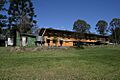
Jimna Single Men's Barracks (former), 2007
|
|||||||||||||||

Jimna
Location in Queensland
|
|||||||||||||||
| Population | 70 (2021 census) | ||||||||||||||
| • Density | 0.222/km2 (0.57/sq mi) | ||||||||||||||
| Postcode(s) | 4515 | ||||||||||||||
| Area | 315.8 km2 (121.9 sq mi) | ||||||||||||||
| Time zone | AEST (UTC+10:00) | ||||||||||||||
| Location | |||||||||||||||
| LGA(s) | Somerset Region | ||||||||||||||
| State electorate(s) | Nanango | ||||||||||||||
| Federal Division(s) | Blair | ||||||||||||||
|
|||||||||||||||
Jimna is a small rural town in the Somerset Region of Queensland, Australia. It is also a locality, which means it's a specific area. In 2021, about 70 people lived in Jimna.
Contents
Geography
Jimna is located on the Jimna Range. This area is about 515 metres (1690 feet) above sea level.
There's a spot called Jimna Diggings in the eastern part of the area. Long ago, people used to dig for gold there.
Mountains of Jimna
Jimna is surrounded by several mountains. Here are some of them, listed from north to south:
- Summer Mountain (26°39′52″S 152°33′54″E / 26.6645°S 152.5650°E), which is 790 metres high.
- Mount Rollman (26°41′53″S 152°32′57″E / 26.6981°S 152.5491°E), 733 metres high.
- Mount Cabinet (26°42′46″S 152°34′01″E / 26.7128°S 152.5670°E), the tallest at 816 metres.
- Mount Constance (26°43′39″S 152°33′41″E / 26.7276°S 152.5613°E), 777 metres high.
- Mount Langley (26°44′01″S 152°35′07″E / 26.7337°S 152.5852°E), 868 metres high.
- Mount Denmark (26°44′04″S 152°32′51″E / 26.7344°S 152.5476°E), 735 metres high.
- Jinker Hill (26°44′12″S 152°27′57″E / 26.7367°S 152.4658°E), 545 metres high.
- Mount Adelaide (26°44′13″S 152°33′11″E / 26.7370°S 152.5531°E), 752 metres high.
- Mount Lofty (26°44′42″S 152°33′26″E / 26.7449°S 152.5573°E), 763 metres high.
- Grey Bluff (26°45′02″S 152°28′22″E / 26.7505°S 152.4729°E), 450 metres high.
- Little Bluff (26°45′06″S 152°28′42″E / 26.7518°S 152.4783°E), 450 metres high.
- Red Bluff (26°45′32″S 152°28′48″E / 26.7588°S 152.4801°E), 465 metres high.
History
The name Jimna comes from an Aboriginal word, djimna. It means "place of leeches."
The Duungidjawu people are the traditional owners of this land. Their language, also known as Wakka Wakka, was spoken in this area. This includes places like Kilcoy and Moore.
Early Settlements
Jimna had its first Post Office open in 1868. It closed in 1879. Later, another Post Office opened in 1927 and closed in 1981.
In 1887, a large area of land was set aside for small farms. This helped more people settle in the region.
Jimna State School
A school called Monsildale Provisional School opened in 1913. It moved in 1923 and was renamed Foxlowe Provisional School. In 1926, it became Jimna Provisional School. Finally, in 1934, it was named Jimna State School.
The school closed down at the end of 2009. Today, the old school site is used as a camping ground. The original school buildings are still there.
Sawmills and Pine Trees
In 1922, a company named Hancock and Gore moved their sawmill to Jimna. This sawmill helped the town grow. Sadly, the sawmill burned down in 1947.
In 1935, the government started a special nursery in Jimna. They grew hoop pine trees there. A community hall was also opened in 1934. When sawmilling became less common in the 1970s, many people moved away. This caused the town's population to shrink.
Population
In 2016, Jimna had 91 people living there. By 2021, the population was 70 people.
Heritage Sites
Jimna has some important historical places. These sites are protected because of their special history:
- The Jimna Fire Tower on Kilcoy-Murgon Road.
- The old Jimna Single Men's Barracks at 4 Tip Road.
Education
There are no schools directly in Jimna. Students usually travel to nearby towns for their education.
- For primary school, options include Kenilworth State Community College, Woodford State School, Mount Kilcoy State School, and Kilcoy State School.
- For high school, students can attend Kilcoy State High School (up to Year 12). Other options are Woodford State School (up to Year 10) and Mary Valley State College (up to Year 10).
Amenities
Jimna has a Cricket Oval (26°39′46″S 152°27′43″E / 26.6627°S 152.4620°E). This oval is also used as a camping ground and a place for helicopters to land. It is right next to the Jimna Hall and the Jimna Sporting Club.
Attractions
Jimna offers a few interesting spots for visitors:
- Eugenia Track Viewing Platform (26°38′17″S 152°27′30″E / 26.6380°S 152.4584°E), located off Peach Trees Road.
- Yednia Lookout (26°45′37″S 152°28′46″E / 26.7604°S 152.4794°E).
- Yeilo Lookout (26°45′33″S 152°28′48″E / 26.7592°S 152.4799°E).
Images for kids
-
Jimna Single Men's Barracks (former), 2007
