Moore, Queensland facts for kids
Quick facts for kids MooreQueensland |
|||||||||||||||
|---|---|---|---|---|---|---|---|---|---|---|---|---|---|---|---|

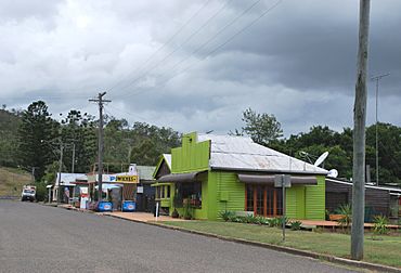
Shops in Moore
|
|||||||||||||||
| Population | 286 (2021 census) | ||||||||||||||
| • Density | 1.615/km2 (4.18/sq mi) | ||||||||||||||
| Postcode(s) | 4314 | ||||||||||||||
| Area | 177.1 km2 (68.4 sq mi) | ||||||||||||||
| Time zone | AEST (UTC+10:00) | ||||||||||||||
| Location |
|
||||||||||||||
| LGA(s) | Somerset Region | ||||||||||||||
| County | Cavendish | ||||||||||||||
| Parish | Colinton | ||||||||||||||
| State electorate(s) | Nanango | ||||||||||||||
| Federal Division(s) | Blair | ||||||||||||||
|
|||||||||||||||
Moore is a small country town and area in the Somerset Region of Queensland, Australia. It's a quiet place with a population of about 286 people, according to the 2021 census.
Contents
Where is Moore?
Moore is located at the bottom of the Balfour Range mountains. It sits between the towns of Esk and Yarraman. The Brisbane River flows through the area, passing east of the town centre.
The main road, the D'Aguilar Highway, runs through Moore. Part of the area on the western side is covered by the Benarkin State Forest.
Mountains and Gaps in Moore
Moore is home to several mountains and mountain passes, which are gaps or low points in a mountain range. Here are some of them:
- Marion Hill (350 metres (1,150 ft) high)
- Mount Miner (408 metres (1,339 ft) high)
- Gwendolen Hill (377 metres (1,237 ft) high)
- Dunwich Gap
- Dryden Gap
- Wilsons Gap
- Grasstree Gap
- Mount Lionel (372 metres (1,220 ft) high)
- Boomerang Gap
- Christy Gap
- The Round Mountain (247 metres (810 ft) high)
A Look Back in Time
The land where Moore is located is the traditional country of the Duungidjawu people. Their language, also known as Kabi Kabi, was spoken in this region. This area includes places like Caboolture, Kilcoy, Woodford, and Moore.
The town was first called Stanley Gate, then Mooretown. In July 1910, it officially became Moore. The name came from the local railway station, which was named after John and William Moore. They were early farmers who raised livestock in the area.
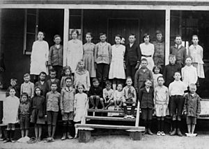
Moore's Old School
Moore Provisional School opened its doors on December 1, 1904. It became Moore State School in 1908. The school stopped operating on December 31, 2006, and officially closed in October 2007. The old school building was sold in 2012.
Post Office and Railway
The Moore Post Office started in September 1905, though a smaller "receiving office" had been open since 1903.
On November 22, 1910, the Brisbane Valley railway line reached Moore. The town had its own railway station. This railway line was important for transporting goods and people, but it closed down in 1993.
In 2018, Moore's postcode changed from 4306 to 4314.
Population of Moore
The number of people living in Moore has changed a little over the years.
- In 2011, Moore and the nearby areas had 315 people.
- By 2016, the population of Moore was 296 people.
- In the most recent census in 2021, 286 people lived in Moore.
Historic Places
Moore has some special places that are listed as heritage sites. This means they are important for their history or unique features and are protected.
- Stonehouse: This historic building is located on the D'Aguilar Highway.
Education in Moore
There are no schools directly in Moore today. The old school closed many years ago. Students in Moore attend primary schools in nearby towns like Linville, Benarkin, or Harlin.
For high school, students can go to schools in Toogoolawah, Kilcoy, Yarraman (up to Year 10), or Nanango.
 | Emma Amos |
 | Edward Mitchell Bannister |
 | Larry D. Alexander |
 | Ernie Barnes |


