Harlin facts for kids
Quick facts for kids HarlinQueensland |
|||||||||||||||
|---|---|---|---|---|---|---|---|---|---|---|---|---|---|---|---|

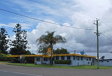
Harlin Hotel
|
|||||||||||||||
| Population | 211 (2021 census) | ||||||||||||||
| • Density | 0.8252/km2 (2.137/sq mi) | ||||||||||||||
| Postcode(s) | 4306 | ||||||||||||||
| Area | 255.7 km2 (98.7 sq mi) | ||||||||||||||
| Time zone | AEST (UTC+10:00) | ||||||||||||||
| Location |
|
||||||||||||||
| LGA(s) | Somerset Region | ||||||||||||||
| County | Cavendish | ||||||||||||||
| Parish | Colinton | ||||||||||||||
| State electorate(s) | Nanango | ||||||||||||||
| Federal Division(s) | Blair | ||||||||||||||
|
|||||||||||||||
Harlin is a small country town in Queensland, Australia. It's located in the Somerset Region. In 2021, about 211 people lived in Harlin.
Contents
Where is Harlin?
Harlin is a small town in the south-east part of Queensland. It sits right on the Brisbane Valley Highway and next to the Brisbane River. The town is about 125 kilometers (78 miles) north-west of Brisbane, which is the capital city of Queensland.
Harlin's Story
How Harlin Got Its Name
The town of Harlin was named after Charlotte Harlin. She was the wife of John Dunn Moore, who owned a large farm called Colinton. Their son, William John Harlin Moore, later became a member of the Queensland Parliament.
Early Days and Services
A place for people to pick up and drop off mail, called a receiving office, opened in Harlin in 1905. Then, a proper Post Office opened in September 1907. It stayed open until 1989.
Harlin Provisional School first opened its doors in 1908. A year later, on January 1, 1909, it officially became Harlin State School.
The 2011 Floods
In 2011, Harlin was cut off by big floods. The rising floodwaters from the Brisbane River and nearby creeks made it impossible to travel. More than 40 travelers got stuck in the town. Luckily, the owners of the Harlin Hotel and the local Caltex service station helped out. They gave shelter to everyone from January 9, 2011, until the water went down and it was safe to leave.
Postcode Change
On February 1, 2018, Harlin's postcode changed from 4306 to 4314.
Who Lives in Harlin?
The number of people living in Harlin changes over time.
- In 2011, about 534 people lived in Harlin and the areas around it.
- By 2016, the population of Harlin was about 173 people.
- In 2021, the number of people living in Harlin grew to 211.
Historic Places in Harlin
Harlin has some special places that are listed as heritage sites. This means they are important parts of history that need to be protected.
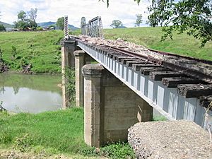
- The Harlin Rail Bridge crosses over Ivory Creek (which used to be called Maronghi Creek).
- The Yimbun Railway Tunnel is located on Sinnamons Lane.
Learning in Harlin
Harlin State School is a government primary school for students from Prep (the first year of school) to Year 6. It's for both boys and girls and is located at 8521 Brisbane Valley Highway.
In 2017, the school had 65 students and 5 teachers. In 2018, there were 58 students and 6 teachers.
There are no high schools in Harlin itself. Students who finish primary school usually go to nearby towns for secondary school. The closest government high schools are:
- Toogoolawah State High School in Toogoolawah
- Kilcoy State High School in Kilcoy
- Nanango State High School in Nanango
 | Madam C. J. Walker |
 | Janet Emerson Bashen |
 | Annie Turnbo Malone |
 | Maggie L. Walker |


