
Fraser Island facts for kids
Quick facts for kids K'gariQueensland |
|||||||||||||||
|---|---|---|---|---|---|---|---|---|---|---|---|---|---|---|---|
.jpg)
The beach from Indian Head, May 2016
|
|||||||||||||||

K'gari
Location in Queensland
|
|||||||||||||||
| Population | 152 (2021 census) | ||||||||||||||
| • Density | 0.09184/km2 (0.2379/sq mi) | ||||||||||||||
| Postcode(s) | 4581 | ||||||||||||||
| Area | 1,655.0 km2 (639.0 sq mi) | ||||||||||||||
| Time zone | AEST (UTC+10:00) | ||||||||||||||
| LGA(s) | Fraser Coast Region | ||||||||||||||
| State electorate(s) | Hervey Bay | ||||||||||||||
| Federal Division(s) | Wide Bay | ||||||||||||||
|
|||||||||||||||
| UNESCO World Heritage Site | |
|---|---|
| Criteria | Natural: vii, viii, ix |
| Inscription | 1992 (16th Session) |
K'gari ( GAH-ree), once known as Fraser Island, is a special sand island in Queensland, Australia. It is so unique that it is listed as a World Heritage site! This amazing island is about 250 kilometers (155 miles) north of Brisbane, the state capital. The World Heritage listing includes the island itself, the waters around it, and parts of the nearby mainland. These areas together form the Great Sandy National Park.
K'gari is the traditional name given by the Butchulla people, who have lived there for thousands of years. It means "paradise". European settlers arrived in 1847 and later named it "Fraser Island". This name honored Captain James Fraser, who was shipwrecked and died on the island in 1836. On June 7, 2023, the island was officially renamed K'gari. This change came after ten years of hard work by the Butchulla people.
In 2021, about 152 people lived on K'gari. However, up to 500,000 people visit this beautiful island every year!
Contents
Geography and Nature

K'gari is separated from the mainland by the Great Sandy Strait. The southern tip is near Tin Can Bay, north of Inskip Point. The northernmost point is Sandy Cape, where a lighthouse operated from 1870 to 1994. This lighthouse was the first permanent European settlement on the island. The closest large town to K'gari is Hervey Bay. Maryborough and Bundaberg are also nearby.
Marloo Bay is on the northeast coast, and Platypus Bay is on the northwest coast. Moon Point is the most western spot on the island.
.jpg)

Eli Creek is the biggest creek on the island's east coast. It flows with an amazing 80 million liters (21 million gallons) of water each day! Eli Creek has its own special wildlife. Coongul Creek on the west coast flows at four to five million liters (one million gallons) per hour.
Some swamps on the island are fens, especially near Moon Point. Fens are a type of wetland. These were discovered in 1996 when experts flew over the island. They noticed distinct patterns of peat, which is decayed plant matter, without trees. This was the first time fens were found in Australia and in a sub-tropical area.
Sand and Rocks
.jpg)
K'gari is made up of a huge amount of sand. All this sand came from rivers in New South Wales, like the Hawkesbury River. It was carried north by ocean currents over a very long time. Along the eastern coast, the ocean is taking away more sand than it deposits. This means the beaches are slowly eroding, which might speed up with sea level rises from climate change. The sand is 98% quartz, a very hard mineral.
All the hills on the island are formed by "sandblows". These are parabolic dunes that move across the island with the wind. They have no plants growing on them. In 2004, there were about 36 sandblows. With year-round south-easterly winds, the sand dunes move about 1 to 2 meters (3 to 6 feet) each year. They can grow up to 244 meters (800 feet) high! As dunes move, they can cover forests and even waterways. The oldest dune system on the island is 700,000 years old. This makes it the oldest recorded sequence in the world.
The colorful sands at Rainbow Gorge, The Cathedrals, The Pinnacles, and Red Canyon are special. They have been stained over thousands of years as sand mixed with clay. A mineral called Hematite acts like cement, making these steep, colorful cliffs. "Coffee rock" is another interesting feature. It is found along the beaches and is named because it turns water the color of coffee when dissolved.
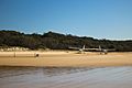
The 120-kilometer (75-mile) beach runs along most of K'gari's east coast. It is so long that it is used as a landing strip for planes! It is even an official main road, so vehicles must give way to aircraft. Along this beach, you can find the Champagne Pools, Indian Head, the Maheno Wreck, and the outflow of Eli Creek. You can also see volcanic rocks at Indian Head and Waddy Point.
Amazing Lakes
.jpg)

K'gari has over 100 freshwater lakes. It has the second-highest number of lakes in Australia, after Tasmania. The freshwater lakes on K'gari are some of the cleanest in the world.
A very popular spot is Lake McKenzie. It is a "perched lake," meaning it sits on top of compact sand and plant matter, about 100 meters (330 feet) above sea level. Lake McKenzie is 150 hectares (370 acres) in size and just over 5 meters (16 feet) deep. The sand on its beach is almost pure silica, which is like glass. The lakes have very few nutrients. Things like sunscreen and soap can cause pollution. The water in some lakes can be stained by natural acids from decaying plants. This makes some perched lakes quite acidic, with a pH level as low as 3.7. This high acidity means not many species can live in these lakes.
Another perched lake is Lake Boomanjin. At 200 hectares (490 acres), it is the largest perched lake in the world! K'gari has 40 perched lakes in total, which is half of all known perched lakes on Earth. Lake Boomanjin gets its water from two creeks that flow through a swamp. The swamp adds natural tannins, which tint the water red. Lake Wabby is the deepest lake on the island, at 12 meters (39 feet) deep. It is also the least acidic, so it has the most aquatic life.
Some lakes on K'gari are "window lakes." These form when the water table (the level of underground water) rises higher than the surrounding land. Most valleys on the island have creeks fed by springs. To protect the lakes, motor boats and jet skis are not allowed.
Climate and Weather
K'gari has a mild climate. The ocean helps keep temperatures from getting too extreme. Temperatures rarely go above 35°C (95°F) or below 5°C (41°F). The air is usually humid. Rain is heaviest during summer and early autumn. The island gets about 1271 mm (50 inches) of rain each year.
Cyclones can be a threat. For example, Cyclone Hamish passed near the island in March 2009 as a very strong storm. Cyclone Oswald in January 2013 was weaker. Both storms caused serious beach erosion, especially at the northern tip of the island.
| Climate data for Fraser Island (Sandy Cape Lighthouse) | |||||||||||||
|---|---|---|---|---|---|---|---|---|---|---|---|---|---|
| Month | Jan | Feb | Mar | Apr | May | Jun | Jul | Aug | Sep | Oct | Nov | Dec | Year |
| Record high °C (°F) | 34.2 (93.6) |
34.3 (93.7) |
34.7 (94.5) |
31.4 (88.5) |
28.7 (83.7) |
27.8 (82.0) |
26.5 (79.7) |
27.2 (81.0) |
29.3 (84.7) |
31.8 (89.2) |
33.8 (92.8) |
34.7 (94.5) |
34.7 (94.5) |
| Mean daily maximum °C (°F) | 29.4 (84.9) |
29.3 (84.7) |
28.5 (83.3) |
26.8 (80.2) |
24.1 (75.4) |
21.7 (71.1) |
21.1 (70.0) |
22.3 (72.1) |
24.3 (75.7) |
26.1 (79.0) |
27.7 (81.9) |
28.9 (84.0) |
25.8 (78.4) |
| Mean daily minimum °C (°F) | 22.3 (72.1) |
22.4 (72.3) |
21.7 (71.1) |
19.9 (67.8) |
17.4 (63.3) |
15.2 (59.4) |
14.3 (57.7) |
15.0 (59.0) |
16.9 (62.4) |
18.7 (65.7) |
20.3 (68.5) |
21.6 (70.9) |
18.8 (65.8) |
| Record low °C (°F) | 16.7 (62.1) |
16.1 (61.0) |
14.6 (58.3) |
13.3 (55.9) |
9.6 (49.3) |
6.7 (44.1) |
5.2 (41.4) |
5.6 (42.1) |
9.4 (48.9) |
11.2 (52.2) |
13.9 (57.0) |
16.0 (60.8) |
5.2 (41.4) |
| Average rainfall mm (inches) | 162.9 (6.41) |
169.0 (6.65) |
156.9 (6.18) |
121.0 (4.76) |
118.2 (4.65) |
109.2 (4.30) |
89.8 (3.54) |
63.0 (2.48) |
51.0 (2.01) |
59.7 (2.35) |
71.1 (2.80) |
99.3 (3.91) |
1,271.1 (50.04) |
| Average rainy days (≥ 0.2mm) | 13.5 | 14.3 | 16.4 | 15.3 | 15.2 | 12.3 | 11.5 | 9.6 | 7.7 | 8.1 | 8.8 | 10.3 | 143 |
| Source: Bureau of Meteorology | |||||||||||||
Animals of K'gari
Mammals
K'gari is home to many different mammals, possibly between 25 and 50 species. You might see swamp wallabies, echidnas, ringtail and brushtail possums, sugar gliders, and bandicoots. There are also potoroos, flying foxes, and dingoes. Swamp wallabies find safety from dingoes in the dense swampy areas. The island is also visited by 19 species of bats.
Until 2003, there were some wild horses, called brumbies, on the island. They were removed by the Environmental Protection Agency. These horses were descendants of Arab horses brought for breeding and logging.
Dingoes

Dingoes used to be common on K'gari, but their numbers are now decreasing. The dingoes here are thought to be some of the last pure dingoes in Eastern Australia. To protect them, pet dogs are not allowed on the island. DNA tests from 2004 suggested the dingoes on K'gari were "pure." However, earlier skull measurements in the 1990s showed some mixed breeds.
Before 1995, there were no official records of dingoes attacking humans on K'gari. In April 2001, a boy named Clinton Gage was tragically attacked and killed by several dingoes. After this sad event, over 120 dingoes were removed by rangers. Four special rangers were then assigned to manage the dingo population, and patrols were increased. There are strict rules and fines for feeding dingoes or leaving food and rubbish out. This helps keep both people and dingoes safe.
In 2008, there were an estimated 120 to 150 dingoes on the island. Sightings have become less common. A researcher from the University of Queensland noted that K'gari dingoes sometimes hunt in large groups, which is unusual. In 2008, dingo-proof fences were built around nine island settlements. These fences help keep dingoes out of towns.
In late 2009, a former ranger claimed that 70% of the dingoes were malnourished. In March 2010, there were three reports of dingoes biting tourists. Visitors have been reminded to follow ranger advice and not try to provoke dingoes for photos.
As of 2015, the dingo population on the island was estimated to be around 180 to 220.
Reptiles and Amphibians
K'gari has recorded 74 different species of reptiles. This includes 18 types of snakes, with one-third of them being dangerous, like the very venomous eastern brown snake. You can also find goannas, geckos, skinks, and frogs. Some frog species have adapted to live in the island's acidic lakes and swamps. They are sometimes called "acid frogs." The island is also home to the recently discovered Fraser Island sand skink. Freshwater turtles, like Kreffts river turtle, live in the island's lakes and creeks.
Saltwater crocodiles are usually found far north of K'gari in tropical areas. However, sometimes during the warmer months (December to March), crocodiles might appear in the waters around K'gari. Several crocodiles, including one over 4 meters (13 feet) long, were seen in 2008–2009. These are thought to be seasonal visitors who return north when it gets cold. Crocodiles do not breed or live permanently on K'gari.

Birds
K'gari is part of an Important Bird Area (IBA). Over 350 different species of birds live on the island. You might spot birds of prey like sea eagles, peregrine falcons, ospreys, and kites. Other common birds include pelicans, terns, honeyeaters, gulls, kingfishers, kookaburras, and cockatoos.
The island is visited by 20 species of migratory wading birds, some coming all the way from Siberia. K'gari provides a home for 22 different types of gulls and terns, four types of falcons, and six types of kingfishers. A rare bird on the island is the eastern ground parrot, which is extinct in some other parts of Australia.

Other Marine Life
Whales, like humpback whales, and some types of dolphins often visit the waters around K'gari. Dugongs and sea turtles can also be found. Great white, bull, and tiger sharks are present. Tiger sharks sometimes come close to fishermen wading in the surf. Mud crabs live on the western side of the island near mangrove estuaries. There are 24 freshwater fish species in the island's lakes.
K'gari has recorded 300 species of ants. Long-finned eels and giant earthworms also live on the island.
Plants of K'gari
K'gari has a wide variety of plants, with more than 865 species thriving there. It is the only place on Earth where tall rainforests grow directly in sand. The island also has the largest area of wallum heath (a type of shrubland) left in Queensland.
In Pile Valley, you can find 1,000-year-old satinay trees. Even though logging happened here, kauri pines are still common in some areas. Other trees and plants include scribbly gums, red gums, piccabeen palms, blue quandong, brush box, and pandanus.
Along the coast, the sand dunes closest to the sea are covered by salt-tolerant plants. These include pigface, goats foot vine, and beach spinifex. Spinifex sericeus is a very important plant. Its decaying leaves break down in the sand, providing important nutrients for other plants like the beach oak. The rare Angiopteris evecta, a fern with the largest fronds in the world, also grows on K'gari. The southwest coast has many mangroves. Sadly, Persoonia prostrata, a shrub native to the island, is now extinct.
As you travel from the east to the west side of the island, the sand dunes get older. This means the plants also get older and more developed in that direction. Each lake on K'gari is surrounded by different zones of plants. These zones typically go from rushes in the shallow water, to pioneer plants on the beaches, then to sedges, heath, paperbarks, shrubs, and finally eucalypt or banksia woodlands.
History and People

Island Names
The oldest known name for the island is 'K'gari' in the Butchulla people's language. It means "paradise".
According to Aboriginal legend, when humans were created and needed a place to live, the mighty god Beiral sent his messenger Yendingie with the goddess K’gari down from heaven to create the land and mountains, rivers and sea. K’gari fell in love with the earth’s beauty and did not want to leave it. So Yendingie changed her into a heavenly island – Fraser Island.
The name Fraser Island came from the story of Eliza Fraser and her survival after a shipwreck. Captain James Fraser and his wife, Eliza, were shipwrecked on the island in 1836. Their ship, the Stirling Castle, was sailing from Sydney to Singapore. It hit coral north of the island. The crew got into two lifeboats and tried to reach the settlement at Moreton (now Brisbane). During this journey, Eliza Fraser gave birth in the leaking lifeboat, but the baby died soon after. Captain Fraser's lifeboat was in bad shape and was left behind by the other boat. The sinking boat and its crew landed on what was then called the Great Sandy Island. It is not fully known how the survivors died, but it was likely from disease, hunger, or conflicts with the local people. Captain Fraser died, leaving Eliza living among the local Aboriginal people.
Six weeks later, Eliza was rescued by a convict named John Graham. He had escaped and lived in the bush, learning the Aboriginal language. He was sent from Moreton after authorities heard about Eliza's situation. He helped negotiate her return. Within six months, Eliza married another sea captain. She moved to England and became a sideshow attraction, telling dramatic stories about her experiences. She died in a carriage accident in Melbourne in 1858 during a visit.
Aboriginal Australians
Archaeological evidence shows that Aboriginal Australians lived on K'gari at least 5,000 years ago. There was a permanent population of 400–600 people. This number grew to 2,000–3,000 in winter because there was plenty of seafood.
When European settlers arrived in the 1840s, it was very difficult for the Butchulla people. European settlement brought weapons, diseases, and a lack of food. By 1890, the Aboriginal population had dropped to only 300 people. Most of the remaining Butchulla people left the island in 1904. They were moved to missions in Yarrabah and Durundur. It is believed that there are up to 500 ancient Aboriginal sites on the island.
In October 2014, the Federal Court officially recognized the Native title rights of the Butchulla people. This means the Indigenous people can now hunt, fish, and take water for their homes. It also opens up opportunities for the Butchulla people to develop ecotourism and other businesses on the island.
European Exploration and Settlement
Early European contact was mostly from explorers and shipwrecks. The first European to see K'gari was James Cook in May 1770. He named Indian Head after seeing Aboriginal people gathered there. After Cook's visit, the Aboriginal people created a song to remember the event. This is the first recorded oral story of Indigenous people observing Europeans.
Matthew Flinders sailed past the island in 1799 and again in 1802. He landed at Sandy Cape while mapping Hervey Bay. His 1814 map did not confirm K'gari was separate from the mainland. However, Flinders did suggest there were shallow, swampy areas in the bay. Two American whalers told Flinders about an opening at Hook Point, between K'gari and the mainland.
In 1842, Andrew Petrie found good land for farming and forests, which attracted settlers to the island. Lieutenant Robert Dayman was the first European to sail between K'gari and the mainland in 1847.
Logging History

Logging on K'gari started in 1863, led by an American named Jack Piggott. Trees like Blackbutt, Queensland kauri, and satinay (Fraser Island turpentine) were cut down a lot because they provided excellent timber. Satinay logs were even sent to Egypt to help build the Suez Canal.
For the first 70 years of logging, bullock drays (carts pulled by oxen) were used to drag timber to loading spots on the beach. Later, railway tracks were built through the forest to make logging easier, but these were later removed. The logging industry continued until 1991. It stopped after concerns were raised by a special inquiry into the island's conservation and management.
Sand Mining
K'gari has valuable deposits of minerals like rutile, ilmenite, zircon, and monazite. Sand mining leases were first given in 1950, and mining continued until 1977. In the 1960s, the Queensland Government secretly gave mining leases to an American company. In 1971, the Fraser Island Defense Organisation (FIDO) fought against giving more leases to the company. Even though over 1,300 objections were made, the leases were still granted.
FIDO took the case to the High Court of Australia, which overturned the decision, saying that the public interest was not being protected. The company continued mining. The Whitlam Government then started Australia's first environmental impact inquiry, which recommended that mining should stop. Finally, Prime Minister Malcolm Fraser canceled the company's mineral export license, which stopped mining on the island. This was a big victory for the conservation movement in Australia. K'gari then became the first place to be included in the Australian Heritage Commission's Register of the National Estate.
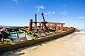
Wreck of the Maheno
_IGP4364.jpg)
A famous landmark on K'gari is the shipwreck of the S.S. Maheno. The Maheno was built in Scotland in 1905 as a luxury passenger ship. It sailed across the Tasman Sea. During World War I, it served as a hospital ship in the English Channel. After the war, it went back to being a passenger ship.
By 1935, the ship was no longer in service and was sold to a company in Japan to be broken up for scrap metal. On June 25, 1935, while being towed to Osaka, it was caught in a strong cyclone about 80 kilometers (50 miles) off the Queensland coast. The towline broke, and on July 9, 1935, the Maheno washed ashore on the east coast of K'gari.
During World War II, the wreck was used for target practice by the RAAF. Special forces from the Fraser Commando School also used it for explosives training. Today, the ship's remains are very rusted, with almost three and a half stories buried under the sand. Because it is dangerous, climbing on the wreck is not allowed.
Fraser Commando School
During World War II, an area near McKenzie's Jetty was used as a special forces training camp. This was the Fraser Commando School, run by the Services Reconnaissance Department (also known as "Z Special Unit"). Thousands of soldiers were trained here because the conditions were similar to those on the Pacific Islands where they fought the Japanese. Lake McKenzie was used for parachute training, and the Maheno wreck was used for practicing explosive demolitions.
Visitors to the site today can still see military relics. These include armor plates used to test armor-piercing explosives and weapons. There is also a concrete map of Singapore Harbour, which was used to plan operations.
Tourism on K'gari


Between 350,000 and 500,000 people visit K'gari each year. One of the main reasons people visit is the chance to see a dingo in its natural home. Visitors are encouraged to use boardwalks and marked tracks to help prevent erosion.
"Central Station" was once the main area for the logging industry on K'gari. Now, it is a popular tourist spot. Some of the rarest ferns grow in the rainforest near this location.
Getting There

You can reach K'gari by ferry from River Heads (south of Hervey Bay) to Kingfisher Bay and Wanggoolba Creek. Another ferry goes from Inskip Point (north of Rainbow Beach) to Hook Point. You can also take a chartered flight from Maroochydore Airport.
A four-wheel drive vehicle is needed for most landings and for traveling around the island (except within the Kingfisher Bay resort). You need a permit for vehicles, which you can get online or at several places in Rainbow Beach. Several companies rent out four-wheel drive vehicles.
Tour buses travel the island. There are also self-drive tours that start regularly from Hervey Bay, Rainbow Beach, and Noosa.
Fishing on K'gari
Tailor are a common fish that people try to catch on K'gari and along the Queensland coast. Other fish caught on the eastern coast include jewfish, golden trevally, and surf bream. In the calmer western waters, you might catch whiting, flathead, and surf bream.
You can use pilchards, bloodworms, yabbies, pipi, and sandworms as bait. Fishing is not allowed in the island's creeks and lakes to protect the wildlife.
Camping on K'gari
There are many campgrounds on K'gari with different facilities. Some main camping areas include Dundubara Campground, Cathedrals on Fraser, Waddy Point campground, and Central Station Tent Sites. Waddy Beach has tent-only campsites. Cornwells Break is a large group site, and One Tree Rocks is a camp zone. You need permits for both camping and vehicle access.
Hiking on K'gari
There are various options for overnight hiking on the island. The most famous is the 90-kilometer (56-mile) long Fraser Island Great Walk. A shorter hike could be starting in Kingfisher Bay (where the ferry drops you off), hiking to Lake McKenzie, staying there for one night, and then hiking back.
Images for kids
-
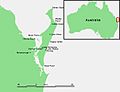
Fraser Island: locator map
-
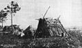
Shelters at Boggimbah, Fraser Island, 1902.
-
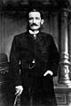
Archibald Meston.
-
The wreck of the S.S. Maheno near Eli Creek, 2019
-
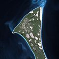
Fraser Island seen from Spot Satellite
-
Scenic flight over Fraser Island, which lands and takes off from the beach
-
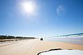
It is popular to drive at the beaches of Fraser Island


.jpg)


See also
 In Spanish: Isla Fraser para niños
