
Gladstone, Queensland facts for kids
Quick facts for kids GladstoneQueensland |
|||||||||
|---|---|---|---|---|---|---|---|---|---|
|
View over the Gladstone CBD and Auckland Hill
The Tondoon Botanic Gardens
Brisbane to Gladstone yacht race
|
|||||||||

Gladstone
Location in Queensland
|
|||||||||
| Population | 45,185 (2021 census) | ||||||||
| Established | 1863 | ||||||||
| Postcode(s) | 4680 | ||||||||
| Time zone | AEST (UTC+10:00) | ||||||||
| Location |
|
||||||||
| LGA(s) | Gladstone Region | ||||||||
| State electorate(s) | Gladstone | ||||||||
| Federal Division(s) | Flynn | ||||||||
|
|||||||||

,_144_Goondoon_Street,_Gladstone,_2014.JPG)


.jpg)
Gladstone is a city on the coast of Queensland, Australia. It is part of the Gladstone Region. In 2021, about 45,185 people lived in the Gladstone urban area.
Gladstone is about 517 kilometers (321 miles) north-west of Brisbane, the state capital. It's also 108 kilometers (67 miles) south-east of Rockhampton. The city is located between the Calliope and Boyne Rivers. Gladstone is home to Queensland's biggest port, which handles many different types of goods. This port is called the Port of Gladstone.
Gladstone is the largest town in its region. The main office for the Gladstone Regional Council is also located here.
Contents
History of Gladstone


Before Europeans arrived, the Gladstone area was home to several Aboriginal tribes. These included the Gooreng Gooreng, Toolooa (or Tulua), Meerooni, and Baiali (or Byellee) peoples.
In May 1770, Captain James Cook sailed past the entrance to Gladstone Harbour. Later, in August 1802, Matthew Flinders was the first European to see the harbor. He named it Port Curtis after Admiral Roger Curtis. In November 1823, John Oxley explored the harbor further. He didn't think much of the area, saying the harbor was hard to enter and the land was too dry.
Despite this, in 1847, the British tried to start a new colony called North Australia at Port Curtis. Colonel George Barney led this effort. On January 25, 1847, his ship, carrying soldiers and convicts, ran aground near Facing Island. The settlers stayed on the island for seven weeks before being rescued. They were then taken to the planned settlement site, now known as Barney Point. Colonel Barney became the Lieutenant Governor of the new colony. However, this settlement only lasted about two months and was very expensive for the British government.
By 1853, a new town was being planned on the shores of Port Curtis. In 1854, Maurice O'Connell was appointed as the government leader. This led to more free settlers moving to the area as land became available.
Gladstone State School, one of Queensland's oldest primary schools, opened on April 1, 1861. In 1863, Gladstone officially became a Municipality. Richard Hetherington was elected as the first mayor. The town was named after the British Prime Minister, William Ewart Gladstone. You can see a 19th-century marble statue of him in the town museum.
Gladstone grew slowly until 1893, when a meatworks (a factory for processing meat) was built at Parsons Point. This helped the town develop more.
In 1949, a big cyclone hit Gladstone, causing a lot of damage.
Gladstone State High School opened in 1953. In 1963, a company called Queensland Alumina Limited built an alumina refinery where the old meatworks used to be. This led to a big expansion of Gladstone's port and a time of major industrial growth and wealth for the city.
Many other schools opened over the years, including Gladstone West State School (1966), Rosella Park State School (1971), Clinton State School (1974), Toolooa State High School (1981), and Kin Kora State School (1981). Trinity College, a private school, started in 1985.
Gladstone Cinemas, a local movie theater, opened in 2001. The Gladstone Library building opened in 2003.
Historic Places in Gladstone
Gladstone has several places that are listed for their historical importance. These include old schools, churches, and buildings like the Post Office and the Art Gallery and Museum.
-
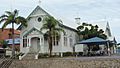
Our Lady Star of the Sea Catholic Church, 2014
-
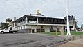
Port Curtis Sailing Club (view from Auckland Inlet), 2014
-
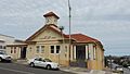
Old Gladstone Post Office, 2014
-
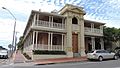
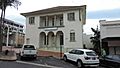
Kullaroo House, 2014
-
Former Commonwealth Bank, 2014
-
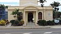
Gladstone Regional Art Gallery and Museum (Old Town Hall), 2014
,_Gladstone,_2014.JPG)
,_Gladstone,_2014.JPG)

,_114_Goondoon_Street,_Gladstone,_2014.JPG)
People and Population
The 2021 census showed that 45,185 people lived in the Gladstone urban area.
- About 6.7% of the people were Aboriginal and Torres Strait Islander.
- Most people (79.3%) were born in Australia. Other common birthplaces included New Zealand (3.3%), England (2.2%), and the Philippines (1.3%).
- English was the main language spoken at home by 87.0% of people.
- For religion, 46.1% said they had no religion. The next most common religions were Catholic (17.1%) and Anglican (11.6%).
Geography of Gladstone

Gladstone and Rockhampton are the two main cities in the Central Queensland region.

Gladstone Suburbs
Gladstone is made up of several suburbs, including:
- Gladstone Central (the historic and business center)
- Barney Point
- Clinton
- Glen Eden
- Kin Kora
- Kirkwood
- New Auckland
- O'Connell
- South Gladstone
- South Trees
- Sun Valley
- Telina
- Toolooa
- West Gladstone
Gladstone Climate
Gladstone has a Tropical Savanna Climate. This means it has a wet season and a dry season, like many places near the tropics. Temperatures in Gladstone have ranged from 4.4°C (39.9°F) to 42.0°C (107.6°F).
| Climate data for Gladstone Radar, Queensland, Australia (1991–2020 normals, extremes 1957–present); 75 m AMSL | |||||||||||||
|---|---|---|---|---|---|---|---|---|---|---|---|---|---|
| Month | Jan | Feb | Mar | Apr | May | Jun | Jul | Aug | Sep | Oct | Nov | Dec | Year |
| Record high °C (°F) | 38.3 (100.9) |
40.1 (104.2) |
42.1 (107.8) |
34.4 (93.9) |
33.2 (91.8) |
29.7 (85.5) |
29.4 (84.9) |
31.6 (88.9) |
33.9 (93.0) |
40.0 (104.0) |
40.1 (104.2) |
39.8 (103.6) |
42.1 (107.8) |
| Mean maximum °C (°F) | 34.1 (93.4) |
33.7 (92.7) |
32.6 (90.7) |
30.7 (87.3) |
28.1 (82.6) |
25.9 (78.6) |
25.5 (77.9) |
26.8 (80.2) |
29.2 (84.6) |
31.2 (88.2) |
32.7 (90.9) |
33.9 (93.0) |
34.1 (93.4) |
| Mean daily maximum °C (°F) | 31.8 (89.2) |
31.4 (88.5) |
30.5 (86.9) |
28.6 (83.5) |
26.0 (78.8) |
23.8 (74.8) |
23.5 (74.3) |
24.8 (76.6) |
27.1 (80.8) |
28.6 (83.5) |
30.5 (86.9) |
31.4 (88.5) |
28.2 (82.7) |
| Daily mean °C (°F) | 27.3 (81.1) |
27.1 (80.8) |
26.2 (79.2) |
24.2 (75.6) |
21.6 (70.9) |
19.3 (66.7) |
18.7 (65.7) |
19.7 (67.5) |
22.1 (71.8) |
23.8 (74.8) |
25.6 (78.1) |
26.8 (80.2) |
23.5 (74.4) |
| Mean daily minimum °C (°F) | 22.8 (73.0) |
22.8 (73.0) |
21.9 (71.4) |
19.8 (67.6) |
17.1 (62.8) |
14.7 (58.5) |
13.9 (57.0) |
14.6 (58.3) |
17.0 (62.6) |
18.9 (66.0) |
20.7 (69.3) |
22.1 (71.8) |
18.9 (65.9) |
| Mean minimum °C (°F) | 20.5 (68.9) |
20.7 (69.3) |
19.9 (67.8) |
17.9 (64.2) |
13.9 (57.0) |
10.7 (51.3) |
9.9 (49.8) |
11.2 (52.2) |
14.3 (57.7) |
16.4 (61.5) |
18.3 (64.9) |
19.6 (67.3) |
9.9 (49.8) |
| Record low °C (°F) | 14.8 (58.6) |
17.2 (63.0) |
16.2 (61.2) |
11.0 (51.8) |
8.5 (47.3) |
6.1 (43.0) |
4.4 (39.9) |
4.7 (40.5) |
9.6 (49.3) |
10.9 (51.6) |
14.7 (58.5) |
15.6 (60.1) |
4.4 (39.9) |
| Average precipitation mm (inches) | 144.8 (5.70) |
139.1 (5.48) |
111.7 (4.40) |
39.2 (1.54) |
37.4 (1.47) |
36.5 (1.44) |
26.8 (1.06) |
29.8 (1.17) |
29.6 (1.17) |
60.0 (2.36) |
50.4 (1.98) |
110.9 (4.37) |
816.2 (32.14) |
| Average precipitation days (≥ 1.0 mm) | 7.9 | 7.8 | 6.6 | 3.8 | 4.4 | 3.8 | 2.9 | 2.6 | 2.7 | 4.9 | 5.0 | 6.9 | 59.3 |
| Average relative humidity (%) | 66.5 | 68.5 | 64.5 | 63.0 | 62.5 | 61.5 | 59.0 | 58.5 | 60.5 | 61.5 | 61.0 | 63.5 | 62.5 |
| Average dew point °C (°F) | 21.3 (70.3) |
21.5 (70.7) |
19.7 (67.5) |
17.4 (63.3) |
14.5 (58.1) |
12.0 (53.6) |
10.7 (51.3) |
11.7 (53.1) |
14.5 (58.1) |
16.9 (62.4) |
18.4 (65.1) |
20.2 (68.4) |
16.6 (61.8) |
| Source 1: Australian Bureau of Meteorology (1957–present extremes) | |||||||||||||
| Source 2: Australian Bureau of Meteorology (1991–2020 normals) | |||||||||||||
Industries in Gladstone

Gladstone's main industries are linked to mining. The Port of Gladstone is Australia's fifth-largest port for many different goods. It is also the world's fourth-largest port for exporting coal. The port has many wharves and terminals. For example, Boyne Wharf is used by the Boyne Island aluminium smelter.
The western part of the harbor has been made bigger. This is mainly to allow more exports of liquified natural gas (LNG). In 2016, a plant was built on Curtis Island to produce and export LNG. This project greatly helped Gladstone's population and housing grow.
Major exports from Gladstone include coal, alumina, aluminum, cement products, and other chemicals. Each year, 50 million tonnes of coal pass through the port. This makes up 70% of all exports.
Gladstone harbor is part of the World Heritage Area of the Great Barrier Reef. It has always been a place where a lot of seafood is caught. In 2011, there were reports of fish with milky eyes. This caused big losses for the local seafood industry.
Gladstone is also a place for tourists to visit. Cruise ships often stop at the port.
Education in Gladstone
Gladstone has many primary and secondary schools.
There are several government primary schools (Prep to Year 6) for boys and girls. These include Gladstone Central State School, Gladstone West State School, Gladstone South State School, Clinton State School, and Kin Kora State School. Rosella Park School is a special government school for students aged five to eighteen with intellectual disabilities. These students come from all over the Gladstone Region.
For secondary education (Years 7-12), there are Gladstone State High School and Toolooa State High School.
Gladstone also has two main private schools: St Johns and Trinity College.
The city is home to two university campuses of Central Queensland University. The local TAFE college also joined Central Queensland University, becoming the Gladstone City Campus.
Community Places
The Gladstone Regional Council runs the Gladstone Library, located on Goondoon Street. The Gladstone branch of the Queensland Country Women's Association meets at their hall on Oaka Lane.
Fun and Recreation

From Gladstone, you can easily reach beautiful islands like Heron Island, Wilson Island, and Curtis Island. You can get there from the marina or local airstrips.
Boyne Island and Tannum Sands
Boyne Island and Tannum Sands are popular places because of their lovely beaches and relaxed way of life. The Millennium Esplanade is a great spot with shelters, barbecues, and walking paths along long stretches of beach. These areas are part of the wider Gladstone region.
Lake Awoonga

A little further away (25 km or 15 miles south of Gladstone) is Lake Awoonga. This recreation area has free barbecues, swimming, and walking trails. There's also a caravan park. Since 1996, the lake has been stocked with many fish, including over 2 million barramundi. So, it's a great place for fishing!
Lake Awoonga also has lots of wildlife. More than 225 types of birds have been seen there, which is over 27% of all bird species in Australia. Lake Awoonga is also the main source of drinking water for Gladstone. This area is also part of the Gladstone region.
Getting Around Gladstone
The Dawson Highway starts in Gladstone and goes west for about 400 km (250 miles) to Springsure.
Trains
Gladstone is an important stop on the North Coast railway line. Long-distance passenger trains operated by QR Traveltrain stop here. Gladstone is also a major point for sending coal from the Moura and Blackwater coal areas to other countries. It's one of the biggest coal export ports in the Southern Hemisphere.
Very long coal trains, up to 1.7 km (1 mile) long, bring coal to be unloaded at terminals in Barney Point, Clinton, and Yarwun. Coal is also sent by train to the Gladstone Power Station and the Queensland Alumina Limited refinery. There are large train facilities at Callemondah to support these operations.
Air Travel
Gladstone Airport is located in the western suburbs of Gladstone, about 6 km (4 miles) from the city center.
QantasLink is the main airline that offers regular passenger flights, mostly using Bombardier Q400 planes. Virgin Australia also started flights in 2011, offering many daily return flights to Brisbane.
In 2009, the airport received a $65 million upgrade, which was finished in 2011.
Sea Travel
The Port of Gladstone is Queensland's largest port for many different goods. It is also the fifth-largest multi-commodity port in Australia. It is the world's fourth-largest terminal for exporting coal.
Media in Gladstone
News
Gladstone has a free newspaper called Gladstone News. It comes out every two weeks and is delivered to many businesses and community spots.
Radio
4CC is Gladstone's local commercial radio station. It has a local breakfast show. Hit Central Queensland is another local commercial radio station. It also has a local breakfast show that is broadcast to Rockhampton and Emerald.
Gladstone also receives radio stations from Rockhampton, like Triple M Central Queensland and 4RO. ABC Capricornia also broadcasts into Gladstone from Rockhampton.
There is also a local community radio station called 91.9 Fresh FM, which plays Christian music.
Television
You can watch WIN Television, Seven Queensland, Southern Cross Ten, ABC, and SBS stations in Gladstone.
The local news programs from WIN News and Seven News often show stories about the Gladstone region.
Sports Teams
Gladstone is home to many sports teams. In 2018, the city even hosted a professional rugby league game at Marley Brown Oval.
Local sports teams include:
- Australian Rules Football: Gladstone Suns
- Cricket: Gladstone Brothers, The Glen, Yaralla
- Basketball: Gladstone Port City Power (Men's and Women's teams)
- Soccer: Central FC (CQ Premier League), and local teams like Central SC, Clinton FC, Gladstone United FC, Meteors FC, Yaralla FC
- Rugby League: Past Brothers, Valleys, Wallabys
- Rugby Union: Gladstone RUFC
- Volleyball: Gladstone Thunder
Famous People from Gladstone
Some notable people who have lived in Gladstone include:
- James Henry Ashton (1819–1889) – He started Ashton's Circus.
- Gary Larson (born 1967) – A former professional rugby league player for Queensland and Australia.
- Hayley Marsten (born 1994) – An award-winning country singer and songwriter.
- Frederick Woolnough Paterson (1897–1977) – A barrister, farmer, and politician.
Sister City
Gladstone has a "Sister City" relationship with Saiki City in Japan. This partnership started in 1996.
