West Gladstone, Queensland facts for kids
Quick facts for kids West GladstoneGladstone, Queensland |
|||||||||||||||
|---|---|---|---|---|---|---|---|---|---|---|---|---|---|---|---|

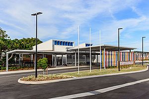
Gladstone West State School, circa 2022
|
|||||||||||||||
| Population | 4,844 (2021 census) | ||||||||||||||
| • Density | 682/km2 (1,770/sq mi) | ||||||||||||||
| Postcode(s) | 4680 | ||||||||||||||
| Elevation | 0–135 m (0–443 ft) | ||||||||||||||
| Area | 7.1 km2 (2.7 sq mi) | ||||||||||||||
| Time zone | AEST (UTC+10:00) | ||||||||||||||
| Location |
|
||||||||||||||
| LGA(s) | Gladstone Region | ||||||||||||||
| State electorate(s) | Gladstone | ||||||||||||||
| Federal Division(s) | Flynn | ||||||||||||||
|
|||||||||||||||
West Gladstone is a lively suburb located in the city of Gladstone, Queensland, Australia. It's part of the wider Gladstone Region. In 2021, about 4,844 people called West Gladstone home.
Contents
Exploring West Gladstone's Location
West Gladstone is bordered by the Auckland Inlet to the west and north-west. Murray Street and Side Street form part of its northern edge. To the east, you'll find Glenlyon Street, and Philip Street marks part of its southern boundary.
The suburb starts at sea level near the Auckland Inlet. It then gently rises towards the east. The highest point is Round Hill, located in the south-east. This hill reaches about 135 meters (443 feet) high.
Dawson Road, which is part of the Dawson Highway, runs through West Gladstone. It connects the suburb from the north-east (near Gladstone Central) to the south-west (leading to areas like Clinton and Kin Kora). The North Coast railway line also passes through West Gladstone, but there are no train stations here.
A Look Back at West Gladstone's History
West Gladstone has grown quite a bit over the years. Many important schools and facilities have opened here.
Schools Opening in West Gladstone
- Gladstone State High School welcomed its first students on 2 February 1953.
- Gladstone West State School opened its doors on 24 January 1966.
- In 1966, a Catholic secondary school started with 23 students. It was first located at the Star of the Sea Church and School in Gladstone CBD.
- By 1967, this Catholic school moved to its current spot in West Gladstone. Here, the Sisters of Mercy started Stella Maris College for girls.
- In 1968, the Marist Brothers opened Chanel College for boys. Later, these two schools joined together to become Gladstone Catholic High School.
- In 1985, the combined school was named Chanel College, serving both boys and girls.
- Rosella Park School opened on 17 May 1971.
Changes to Mater Hospital Gladstone
The Mater Hospital Gladstone first opened on 14 April 1999. It was run by the Mater Group, a Catholic healthcare organization. However, in April 2020, the Mater Group sold the hospital to Queensland Health. It then became the West Wing of Gladstone Hospital. The Mater Group decided to close the private hospital because fewer private patients were using it, making it hard to keep running. Before closing, it had already stopped offering maternity services in 2018 and was only doing day surgeries by 2020.
Education in West Gladstone
West Gladstone is home to several schools, offering education from primary to secondary levels.
- Gladstone West State School is a government primary school for students from Prep (the first year of school) to Year 6. It's located on Boles Street. In 2018, it had 641 students and also offers a special education program.
- Rosella Park School is a special school for primary and secondary students, from Prep to Year 12. You can find it on Park Street. In 2018, 78 students attended this school.
- Gladstone State High School is a government secondary school for students in Years 7 to 12. It's on Dawson Road. In 2018, it had 1,512 students. This school also has a special education program. It includes the EQIP Technical College, which is a technical education unit for Years 11 and 12 students on Boles Street.
- Chanel College is a Catholic secondary school for boys and girls in Years 7 to 12. It's located on Paterson Street. In 2018, 481 students were enrolled here.
Important Facilities in West Gladstone
West Gladstone has several key facilities that serve the community:
- Gladstone Fire & Rescue Station is ready to help at 3 Charles Street.
- Gladstone Hospital is a public hospital located at 10 Park Street, providing healthcare services.
- Gladstone Cemetery is a place for burials, found at the corner of Dawson Highway and Cemetery Road.
Shopping and Parks in West Gladstone
You'll find places to shop and relax in West Gladstone.
Shopping
Stockland Gladstone is a large shopping centre. It's located at 75 Dawson Highway and also has an entrance across the road at 195 Philip Street.
Parks
West Gladstone has many parks where you can enjoy the outdoors:
- Ailsa Street Park
- Auckland Creek Park
- Boles Street Park
- Carramar Park
- Coase Park
- Derribong Park
- Glen Creek Park
- Illoura Park
- Kooyong Park
- Lions Park
- Matson Crescent Park
- Palm Drive Junior Sporting Complex
- Potters Park
- Reg Tanna Park
- Webb Park
 | Delilah Pierce |
 | Gordon Parks |
 | Augusta Savage |
 | Charles Ethan Porter |


