Clarendon, Queensland facts for kids
Quick facts for kids ClarendonSomerset Region, Queensland |
|||||||||||||||
|---|---|---|---|---|---|---|---|---|---|---|---|---|---|---|---|

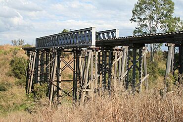
Lockyer Creek Railway Bridge, 2008
|
|||||||||||||||
| Population | 232 (2021 census) | ||||||||||||||
| • Density | 12.82/km2 (33.2/sq mi) | ||||||||||||||
| Postcode(s) | 4311 | ||||||||||||||
| Area | 18.1 km2 (7.0 sq mi) | ||||||||||||||
| Time zone | AEST (UTC+10:00) | ||||||||||||||
| Location | |||||||||||||||
| LGA(s) | Somerset Region | ||||||||||||||
| State electorate(s) |
|
||||||||||||||
| Federal Division(s) | Dickson | ||||||||||||||
|
|||||||||||||||
Clarendon is a small country area in the Somerset Region of Queensland, Australia. It is a quiet place with a population of 232 people, according to the 2021 census.
Contents
Where is Clarendon?
Clarendon is named after Lake Clarendon, which is about 20 kilometers (12 miles) to its southwest.
The Lockyer Creek
A creek called Lockyer Creek flows into Clarendon from the southwest. It forms part of the southern edge of the area. The creek then winds through Clarendon and creates its northern, northeastern, and eastern borders. Finally, it flows out to the southeast.
A Look Back in Time
Clarendon has a history that includes old train stations, schools, and post offices.
The Old Train Station
Clarendon used to have a train station on the Brisbane Valley railway line. This railway line is no longer used. The station was open from 1886 to 1995. It was first called Tarampa railway station before its name changed to Clarendon.
Early Schools
An early school called Lockyer Creek Provisional School opened around 1891. It was renamed Lockyer Provisional School in 1892. This school closed in 1915 and was located "near Clarendon."
The Post Office
The Clarendon Post Office opened on 1 July 1927. Before that, a smaller "receiving office" had been open since 1873. It had different names like Tarampa, Watson's, and Clarendon. The post office eventually closed in 1951.
Clarendon State School
Clarendon State School opened its doors on 23 January 1929. It has been teaching local children ever since.
How Many People Live Here?
In 2016, Clarendon had 244 people living there. By 2021, the population was 232 people.
Important Old Places
Clarendon has some places that are listed as important heritage sites. This means they are protected because of their historical value.
Lockyer Creek Railway Bridge
One of these important sites is the Lockyer Creek Railway Bridge. This bridge was part of the old Brisbane Valley railway line. It is a significant landmark in the area.
Learning in Clarendon
Education is important in Clarendon, especially for younger students.
Clarendon State School Today
Clarendon State School is a government primary school. It teaches boys and girls from Prep (the first year of school) to Year 6. The school is located at 507 Clarendon Road. In 2018, it had 84 students and a team of teachers and staff.
High School Options
There are no high schools directly in Clarendon. Students who are ready for secondary school usually go to Lowood State High School. This school is in the neighboring town of Lowood, which is to the southeast.
Local Services
Clarendon has some important community facilities.
Lowood Cemetery
Even though it's called Lowood Cemetery, this burial ground is actually located within Clarendon. It is on Clarendon Road, close to Nunns Road. The Somerset Regional Council manages the cemetery.
 | Valerie Thomas |
 | Frederick McKinley Jones |
 | George Edward Alcorn Jr. |
 | Thomas Mensah |


