Basin Pocket, Queensland facts for kids
Quick facts for kids Basin PocketIpswich, Queensland |
|||||||||||||||
|---|---|---|---|---|---|---|---|---|---|---|---|---|---|---|---|

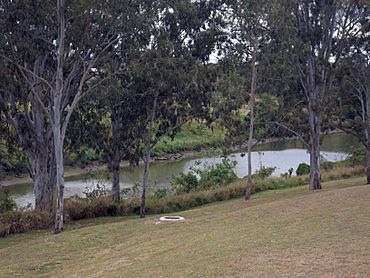
Bremer River and park, 2015
|
|||||||||||||||
| Population | 931 (2021 census) | ||||||||||||||
| • Density | 1,550/km2 (4,000/sq mi) | ||||||||||||||
| Postcode(s) | 4305 | ||||||||||||||
| Area | 0.6 km2 (0.2 sq mi) | ||||||||||||||
| Time zone | AEST (UTC+10:00) | ||||||||||||||
| Location |
|
||||||||||||||
| LGA(s) | City of Ipswich | ||||||||||||||
| State electorate(s) | Ipswich | ||||||||||||||
| Federal Division(s) | Blair | ||||||||||||||
|
|||||||||||||||
Basin Pocket is a suburb located in Ipswich, within the City of Ipswich, Queensland, Australia. In 2021, about 931 people lived in Basin Pocket.
Contents
What's Basin Pocket Like?
Basin Pocket is bordered by the Bremer River to the north and west. To the east and south, it shares a border with East Ipswich.
Most of the land in Basin Pocket is used for homes. There are also parks along the riverbanks. You won't find many shops right in Basin Pocket. However, there are some basic shops nearby in East Ipswich. These are just outside the suburb's south-eastern edge.
A Look Back in Time
How Basin Pocket Got Its Name
The name "Basin Pocket" comes from a natural widening in the river called "The Basin." This wider part of the river was perfect for large river steamers to turn around. They would do this before or after docking at Ipswich.
An explorer named Allan Cunningham first wrote about "The Basin" in 1828. Later, a person named Rev. Dr John Dunmore Lang even thought Basin Pocket might have been a better place for the main town of Ipswich.
Early Transport and Community
In the 1860s, a family named Lawrence settled in Basin Pocket. William Isaac Lawrence started a ferry service across the river. This ferry connected Basin Pocket with North Ipswich. Today, this ferry service no longer exists.
Historic Buildings
Over the years, several churches were built in Basin Pocket.
- The Primitive Methodist church opened on 8 December 1867. Before that, services were held in a rented house for about a year.
- St John's Anglican Church opened on 3 September 1921. It was officially dedicated a week later. This church closed around 2018.
- St Philomene's Catholic Church was officially opened on 2 June 1940.
Learning and Fun
Schools Nearby
Basin Pocket does not have its own schools. Young students usually go to Ipswich East State School. This primary school is located in nearby East Ipswich. For older students, the closest high schools are Bremer State High School in Ipswich and Bundamba State Secondary College in Bundamba.
Parks and Activities
Basin Pocket has some great places for outdoor activities and community events:
- J Perrett Memorial Park
- McLeod Street Park, which also has plans for a boat ramp
- Horace J Harper Band Hall, home to the Ipswich Model Band. This band started in 1906 and is the oldest surviving brass and concert band in Ipswich!
- West End Football Club, a local sports club.
 | Kyle Baker |
 | Joseph Yoakum |
 | Laura Wheeler Waring |
 | Henry Ossawa Tanner |


