
Oxley Wild Rivers National Park facts for kids
Quick facts for kids Oxley Wild Rivers National ParkNew South Wales |
|
|---|---|
|
IUCN Category Ib (Wilderness Area)
|
|

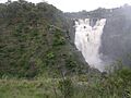
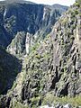
Apsley Falls, located within the national park
|
|

Oxley Wild Rivers National Park
Location in New South Wales
|
|
| Nearest town or city | Yarrowitch |
| Established | 26 September 1986 |
| Area | 1,452.33 km2 (560.7 sq mi) |
| LGA(s) | Port Macquarie Hastings City Council Walcha Shire |
| Managing authorities | NSW National Parks & Wildlife Service |
| Website | Oxley Wild Rivers National Park |
| See also | Protected areas of New South Wales |
The Oxley Wild Rivers National Park is a large national park in New South Wales, Australia. It is located in the Northern Tablelands region. This park covers about 145,223 hectares (358,850 acres). It is found 445 kilometers (277 miles) north of Sydney.
The park is named after John Oxley, an Australian explorer. He traveled through this area in 1818. Oxley Wild Rivers National Park is one of the biggest national parks in New South Wales.
This park is part of the Gondwana Rainforests of Australia World Heritage Site. It was added to the World Heritage list in 1986. Later, in 2007, it was also added to the Australian National Heritage List. The park is special because it has a lot of dry rainforests. These forests are home to many different plants and animals, including some rare or endangered species. You can also find at least fourteen waterfalls here.
Contents
- Park History: Exploring Oxley Wild Rivers
- Geography: Rivers, Gorges, and Waterfalls
- Geology: How the Gorges Were Formed
- Flora: Plants of the Park
- Fauna: Animals of the Park
- Attractions: Places to Visit in the Park
- Apsley Falls: A Stunning Gorge View
- Tia Falls: Waterfalls and Walks
- Budds Mare: Views Over Dry Rainforest
- Wollomombi Falls: Australia's High Waterfalls
- Dangars Gorge and Falls: Great Walks and Picnics
- Other Campgrounds: Riverside, Halls Peak, Youdales Hut, East Kunderang
- Bicentennial National Trail: Horse Riding and Hiking
- Gara Gorge: Hydro-Electric History and Caves
- Weeds and Feral Animals: Protecting the Park
- Images for kids
- See also
Park History: Exploring Oxley Wild Rivers

For thousands of years, the valleys and plateaus of this area were home to the Dangaddi Aboriginal people. Their descendants now live near the lower Macleay River. Signs of their presence, like marked trees and a cave shelter, have been found.
In 1818, explorer John Oxley tried to go down the Apsley valley. But the steep gorges made it too hard. He had to go around the top of the Apsley Falls. After Oxley, the first non-Aboriginal people to enter these remote valleys were cedar-getters. They were looking for Australian red cedar trees. They would float the cut timber down the river to Kempsey.
.JPG)
Since the 1840s, cattle have grazed in the Macleay River Gorges. There were special spots with yards and huts for gathering cattle. One of these, the Middle Yards Hut, was part of a huge cattle station. It has been restored and you can still see it today.
In the late 1800s, people found gold and antimony in the gorges. Mines were set up in places like Halls Peak and Hillgrove. There were even plans for hydro-electric power plants to run the mines. You can still see parts of these old schemes along the Styx River and at Gara Gorge.
In 1976, experts realized the Apsley Macleay Gorges were a true wilderness area. At first, only small parts were protected. In the late 1970s, there was a plan to build a hydro-electric dam in the Apsley Valley. But a study suggested creating a national park instead. So, in 1986, the Oxley Wild Rivers National Park was officially created. This helped protect nature, cultural history, and encourage tourism. More land was added over the years, making it even bigger.
In 1994, the park became a World Heritage site. This means it's recognized as very important globally. In December 2009, lightning caused a large bushfire in the Youdales Hut area. The hut was safe, but a big part of the park was burned.
Geography: Rivers, Gorges, and Waterfalls

Oxley Wild Rivers National Park sits along the Great Escarpment. This is where the high Northern Tablelands drop steeply down to the east coast. The park is famous for its amazing gorges, waterfalls, and dry rainforests.
Many rivers flow through the park. These include the Apsley River, Macleay River, Wollomombi River, Chandler River, Tia River, Styx River, Gara River, Yarrowitch River, Oaky River, and Kunderang Brook.
The park also has many beautiful waterfalls. Some of the most well-known are Wollomombi Falls, Apsley Falls, Tia Falls, and Dangars Falls. There are also many smaller cascades. The waterfalls look their best after it rains. You can easily reach the main waterfalls by car.
Geology: How the Gorges Were Formed

The landscape of the park started forming millions of years ago. Muddy sediments under ancient oceans turned into hard rocks. Then, movements of the Earth's plates and volcanic eruptions pushed these rocks upwards. This created the Great Dividing Range, a high plateau that sloped gently west and dropped steeply east.
Over millions of years, wind, rain, storms, and ice slowly carved out the plateaus. Rivers and streams gradually cut into the eastern edge of the tableland. This created the deep gorges we see today. These gorges eventually formed one long, continuous escarpment. The steep cliffs are still eroding and moving west, which you can see at places like Wollomombi, Dangars, and Apsley Gorges.
Flora: Plants of the Park

The Apsley Macleay Gorges are a special meeting point for plants from both the moist eastern coast and the dry western areas. Over 950 native plant species have been found here. About 36 of these are rare or threatened.
Some rare plants include Grevillea obtusiflora and the Wollomombi or gorge wattle (Acacia blakei). You might also spot some Australian red cedar trees in remote spots. Other threatened plants are the wedge-leaved guinea flower (Hibbertia hermanniifolia) and the gorge hakea (Hakea fraseri). The beautiful Caladenia orchid has been seen at Long Point.
The park's dry rainforests have at least 187 plant species. These areas look like dense, dark green patches of brush box trees. The adaptable bird's nest fern grows on trees or rocks. Other plants in these rainforests include native rosella (Hibiscus heterophyllus), Moreton Bay fig (Ficus macrophylla), and red kamala (Mallotus philippensis).
Open forests and woodlands are filled with different kinds of trees. Common species include rough-barked apple (Angophora floribunda) and various types of gum trees like New England blackbutt (Eucalyptus andrewsii) and yellow box (Eucalyptus melliodora). You might also see orchids growing on some of these trees.
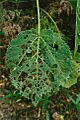
Be careful of the stinging tree (Dendrocnide excelsa). Its leaves and stems have fine hairs that cause severe pain if you touch them. Also, avoid the lawyer vine (Smilax australis), which has prickly climbing stems that can catch on your clothes.
The areas under the main trees often have plants like Acacia (wattles), Bursaria spinosa (blackthorn), and Xanthorrhoea (grass trees).
On the cliffs, where conditions are tough, many rare shrubs grow. These include broadleaf hopbush (Dodonaea rhombifolia) and Grevillea beadleana. The narrow-leaved bertya (Bertya ingramii) is an endangered shrub found only in two spots, growing near cliff edges.
Fauna: Animals of the Park

Oxley Wild Rivers National Park is home to many animals, with over 350 species recorded. This includes 55 different kinds of mammals. The park is a very important safe place for the brush-tailed rock-wallaby. The largest known group of these wallabies lives in the Green Gully area.
Other animals you might find in the park include bandicoots, bats, koalas, wombats, and many small ground mammals. You might also see quolls, common brushtail possums, sugar gliders, platypus, echidnas, wedge-tailed eagles, peregrine falcons, and dingoes.
Over 173 different bird species have been seen in the park. There are also 38 types of reptiles and 19 types of amphibians. Skinks, goannas, tortoises, lizards, snakes, frogs, and fish live here, especially near the rivers. The speckled longfin eel is interesting because it breeds in the ocean, and then the young eels return to the Apsley–Macleay River system.
The park protects 12 species that are listed as threatened. These include five mammals (like the brush-tailed phascogale and tiger quoll), four birds (like the glossy black cockatoo and turquoise parrot), one reptile (carpet python), and two frogs. The park is also home to the Macleay River tortoise, a newly found species, and the rare Hastings River mouse, which is in danger of disappearing.
Attractions: Places to Visit in the Park
You can usually get to the park by car using the Waterfall Way (east of Armidale) or the Oxley Highway (east of Walcha). Some areas, like Riverside, Youdales Hut, and East Kunderang, need a 4WD vehicle, a special permit, and a key to enter.
Here are some popular spots you can visit:
Apsley Falls: A Stunning Gorge View

The Apsley Falls are about 20 kilometers (12 miles) east of Walcha, just off the Oxley Highway. Here, the high Northern Tablelands plateau drops sharply into deep gorges. You can take a 52-meter (171-foot) steel stairway to a viewing deck. This deck has great views of the deep gorge and the two large waterfalls. There are two walking tracks, picnic areas, and a camping spot for overnight stays.
Tia Falls: Waterfalls and Walks

Tia Falls is near Tia, about 38 kilometers (24 miles) east of Walcha. It's about 6 kilometers (4 miles) off the Oxley Highway. You'll find waterfalls and two walking tracks here: the Falls and Gorge Walk (1.5 km return) and the Tiara Walk (5 km return). There are also picnic facilities and bush camp sites for staying overnight.
Budds Mare: Views Over Dry Rainforest
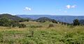
Budds Mare campground is 44 kilometers (27 miles) east of Walcha. Part of the road is unpaved and can be rough for regular cars. From Budds Mare, a short walk leads to a lookout with amazing views over the dry rainforest in the Apsley River Gorge. You can see Paradise Rocks and even Round Mountain. There's also a challenging 8-kilometer (5-mile) walk down to the Riverside Visitor Area on the Apsley River. Facilities include campsites, toilets, picnic tables, and wood barbecues.
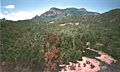
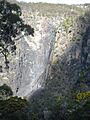
Wollomombi Falls: Australia's High Waterfalls
The Wollomombi Falls gorge is home to two waterfalls: Wollomombi Falls (one of Australia's highest) and Chandler Falls. It's about 40 kilometers (25 miles) east of Armidale on the Waterfall Way. Visitors come for the rugged scenery, picnic spots, and walks along the gorge rim. You can also hike down to the riverbed. The area has drinking water, toilets, a shelter, and bush camp sites.
Dangars Gorge and Falls: Great Walks and Picnics

Dangars Gorge and Falls are 22 kilometers (14 miles) south-east of Armidale. This spot has beautiful Dangars Falls and is a starting point for several walks. The McDirtys Walk is 6.9 kilometers (4.3 miles) return and takes about 3 hours. It leads to lookouts over the falls and gorge. The Salisbury Waters Walk is a difficult 14-kilometer (8.7-mile) walk that takes about 8 hours. It's a great way to explore the gorge. You can picnic, camp, and bushwalk here.
Other Campgrounds: Riverside, Halls Peak, Youdales Hut, East Kunderang
- Long Point is accessible from the historic gold mining town of Hillgrove. It has several walks, including the easy Cassinia Walk and the longer Chandler View Circuit Walk. There are lookouts with views over the Chandler and Macleay Gorges. Facilities include campsites, toilets, and picnic tables.
- Riverside Rest Area is on the Apsley River, 50 kilometers (31 miles) east of Walcha. You need a 4WD vehicle, a permit, and a key to get here. It's great for swimming, hiking, fishing, and photography.
- Halls Peak camping area is off Raspberry Road, east of Armidale. It's a very steep 4WD trail down to a camping area on the Chandler River. You can see the Halls Peak Mine nearby.
- Youdales Hut is a historic timber hut built in the 1930s. It's about 96 kilometers (60 miles) from Walcha. You need a 4WD, a permit, and a key to visit. It's perfect for picnics, swimming, and short walks.
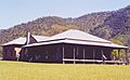
- East Kunderang Homestead is on the Macleay River, 112 kilometers (70 miles) east of Armidale. This historic homestead, built in the 1890s, has been restored. You can book it for up to ten people. Marys View, a lookout nearby, offers amazing views of the Macleay Gorges.
Bicentennial National Trail: Horse Riding and Hiking
The Bicentennial National Trail goes through the park for about 75 kilometers (47 miles). This trail is for walking and horse riding. It follows Kunderang Brook and passes East Kunderang Homestead. This journey usually takes at least five days for walkers and four days for horse riders. There are many creek and river crossings, and some steep climbs. Historic huts like Left Hand and Middle Yards are available for use by trekkers.
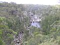
Gara Gorge: Hydro-Electric History and Caves

Gara Gorge is 18 kilometers (11 miles) south-east of Armidale. Here, you can see the remains of Australia's first public hydro-electric scheme from 1894. It's a picnic area with tables, toilets, and barbecues. The Blue Hole is a popular spot for swimming. The 5-kilometer (3-mile) Threlfall Walk follows the old hydro-electric scheme route. Crombies Cave, Australia's longest granite cave, is also nearby. You can explore part of this beautiful cave.
Weeds and Feral Animals: Protecting the Park
The park faces challenges from introduced plants (weeds) and animals (feral animals).
Weeds: Unwanted Plants
Some of the main weeds are giant Parramatta grass, lantana, prickly pear, and blackberry. Lantana has spread in warmer areas and even into rainforests, harming the park's World Heritage values. These weeds are being controlled using special sprays. The cactus moth helps control prickly pear.
Feral Animals: Impact on Wildlife

Feral cats and foxes live in the park and can harm native animals. Wild dogs, including dingoes and dog hybrids, are also present. The park service works with landowners to control these animals using baiting, shooting, and fencing. Feral pigs cause a lot of damage by digging up the ground, which leads to soil erosion and more weeds. They are controlled by trapping, poisoning, and shooting. Feral goats compete with the threatened brush-tailed rock-wallabies for food. They are controlled by shooting. Over 100 feral horses (brumbies) have been caught and re-homed from the Apsley area.
Images for kids
-
Apsley Falls, located within the national park
-
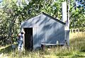
Green Gully Hut
-
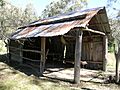
Restored early 20th century Bark Hut constructed by the Brennan family for mustering trips
-
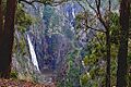
Wollomombi and Chandler Falls
-
Dangars Gorge, near Armidale
-
Stinging tree (Dendrocnide excelsa)
-
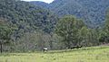
Green Gully area, Yarrowitch, NSW
-
Paradise Rocks and Apsley River from The Terrace, Riverside
-
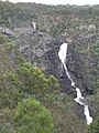
The three drops of the Tia Falls
-
Dangars Falls, near Armidale
-
The East Kunderang homestead
-
The Gara Gorge, near Armidale
-
Brumbies on the Chandler River

See also
 In Spanish: Parque nacional Ríos Salvajes de Oxley para niños
