Waterfall Way facts for kids
Quick facts for kids Waterfall WayNew South Wales |
|
|---|---|
 |
|
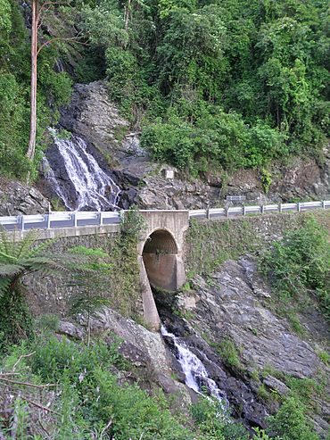
| Newell Falls, Waterfall Way, Dorrigo National Park | |
| General information | |
| Type | Highway |
| Length | 169.8 km (106 mi) |
| Route number(s) |
|
| Former route number |
|
| Major junctions | |
| East end | |
| West end | |
| Location(s) | |
| Major settlements | Bellingen, Dorrigo, Ebor |
| Highway system | |
| Highways in Australia National Highway • Freeways in Australia Highways in New South Wales |
|
The Waterfall Way is a famous road in New South Wales, Australia. It stretches from the Pacific Highway in the east to the New England Highway near Armidale. This road is known for being one of Australia's most beautiful drives.
As you travel along Waterfall Way, you'll discover amazing natural sights. It passes through seven national parks! Three of these parks are so special that UNESCO has listed them as World Heritage Areas. They are part of the Gondwana Rainforests of Australia, which are ancient rainforests. The road gets its name from the many waterfalls you can see, especially in Dorrigo National Park.
This route is also important because it connects the coast of New South Wales with the inland areas. Because of this, many cars use it, even though some parts can be a bit tricky to drive on.
Contents
Exploring the Waterfall Way: A Scenic Journey
Your adventure on Waterfall Way begins near Raleigh. This town is located between Urunga and Coffs Harbour. The road first follows the south side of the Bellinger River, leading you through the lovely town of Bellingen.
After crossing the Bellinger River, the road starts to climb a big hill called an escarpment. This part of the journey takes you past the edge of the Dorrigo rainforest. You'll even cross over the Newell and Sherrard waterfalls, which are why the road is called Waterfall Way! It's hard to stop right at these falls, but you can see Newell Falls from a special rest area nearby.
Discovering Dorrigo's Natural Wonders
At the top of the escarpment, about 750 meters (2,460 feet) high, you can take a short side trip to Griffith's Lookout. From here, you'll get amazing views of the Bellinger River National Park and the valley below.
Just a little further, you'll find the visitor center for the Dorrigo National Park. This park is famous for its "skywalk," which is a walkway high above the trees, and its many walking trails. You can also easily visit Dangar Falls, a beautiful waterfall about 2.4 kilometers (1.5 miles) north of Dorrigo. It's located on the Bielsdown River.
After passing through Dorrigo town, the road continues across the Dorrigo Plateau. This area has lots of farms and open land. You'll then cross the start of the Nymboida River. The Bicentennial National Trail, a long walking and riding path, follows part of this road before you reach Ebor.
Waterfalls and Parks Beyond Ebor
About nine kilometers (5.6 miles) after a turn, you'll reach the village of Ebor. This village is close to the Guy Fawkes River National Park and the impressive Ebor Falls.
Between Ebor and Wollomombi, the road goes through the 8,839-hectare (21,842-acre) Cathedral Rock National Park. You can also find the Yooroonah Tank Barrier, a historic site, about 12 kilometers (7.5 miles) southwest of Ebor.
After Ebor, you'll pass a turnoff that leads to the Dutton Trout Hatchery and Point Lookout. These spots are about 10 kilometers (6.2 miles) east of Waterfall Way, inside the New England National Park. Further along, the Wollomombi Falls are about 1 kilometer (0.6 miles) south of the road. The huge 145,000-hectare (358,300-acre) World Heritage listed Oxley Wild Rivers National Park is easy to get to from Wollomombi Falls.
From here, the road passes about 5 kilometers (3.1 miles) north of the old mining village of Hillgrove. You can also find viewing platforms at Bakers Creek Falls and the Metz Gorge. There are other interesting places to visit on your way to Armidale. For example, the Gara Gorge is 18 kilometers (11.2 miles) southeast of Armidale, just off Waterfall Way.
Road Conditions and Changes
The Waterfall Way is a sealed road, meaning it's paved. However, some parts are quite narrow. There's a steep, winding section that is about 14 kilometers (8.7 miles) long. In recent years, heavy storms and sudden floods have damaged parts of the road where it climbs into the mountains. This has sometimes meant that traffic is limited to one lane, especially near the waterfalls on the Dorrigo Range.
The road used to be called State Route 78. But in 2013, its name changed to B78 as part of a new road numbering system.
Key Road Connections
The eastern end of Waterfall Way connects with Giinagay Way and the Pacific Highway near Raleigh. If you're driving south on the Pacific Highway, Giinagay Way helps you get onto Waterfall Way. There are also special ramps for getting on and off the Pacific Highway if you're heading north. Waterfall Way actually goes over the Pacific Highway using a bridge and ramps.
The western end of Waterfall Way is in Armidale. It connects with the New England Highway (A15).
 | Anna J. Cooper |
 | Mary McLeod Bethune |
 | Lillie Mae Bradford |

