
Chandler River (New South Wales) facts for kids
Quick facts for kids Chandler River |
|
|---|---|

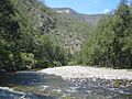
Halls Peak Mine and the Chandler River in Oxley Wild Rivers National Park
|
|
| Country | Australia |
| State | New South Wales |
| Region | New England Tablelands (IBRA), Northern Tablelands |
| Local government area | Armidale Dumaresq |
| Physical characteristics | |
| Main source | Great Dividing Range northeast of Armidale and southeast of Guyra 1,260 m (4,130 ft) |
| River mouth | confluence with the Macleay River below Table Top Mountain, within Cunnawarra National Park 210 m (690 ft) |
| Length | 110 km (68 mi) |
| Basin features | |
| River system | Macleay River catchment |
| Tributaries |
|
| Waterfall | Chandler Falls |
The Chandler River is a cool river in the Northern Tablelands area of New South Wales, Australia. It's part of the larger Macleay River system. This river flows all year round, making it a constant feature of the landscape.
Contents
What is the Chandler River?
The Chandler River starts high up on the eastern side of the Great Dividing Range. This is a big mountain range in Australia. The river begins near the towns of Armidale and Guyra.
Where Does the River Flow?
The Chandler River flows mostly towards the south. As it travels, other smaller rivers and streams join it. These joining rivers are called tributaries. Some important tributaries include the Wollomombi, Oaky, and Styx rivers.
Finally, the Chandler River meets the Macleay River. This meeting point is called a confluence. It happens near Table Top Mountain, inside the Cunnawarra National Park and Oxley Wild Rivers National Park. The river drops about 1,050 metres (3,440 feet) over its 111-kilometre (69-mile) journey.
Amazing Gorges and Waterfalls
As the Chandler River flows through the Cunnawarra National Park and Oxley Wild Rivers National Park, it carves out amazing gorges and creates beautiful waterfalls. One of these is the Chandler Falls.
Nearby, you can also find the Wollomombi Falls. While not directly on the Chandler River, it's very close by. From the Wollomombi Falls lookout, you can see incredible views of the gorges. There are also walking paths that go down into the Chandler River valley.
Visiting the River Area
The Chandler River area is a great place to explore nature. The Waterfall Way road crosses the Chandler River near the town of Wollomombi.
There's a camping spot called Halls Peak right on the river banks. It's for people who want to camp in a quiet, remote area. The path to the campsite is quite steep. The NSW National Parks & Wildlife Service (NPWS) recommends using a special type of 4WD vehicle to get there.
How Did the River Get its Name?
The Chandler River was named by Captain Dumaresq. He named it after one of his stockmen, who was a person who looked after cattle.
Animals Around the River
In the upper parts of the river, you might see beef cattle grazing (eating grass). In the lower parts of the river, wild horses, called brumbies, roam freely.
Images for kids
-
Halls Peak Mine and the Chandler River in Oxley Wild Rivers National Park
