Macleay River facts for kids
Quick facts for kids Macleay River |
|
|---|---|

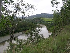
Macleay River, viewed at Lower Creek
|
|
|
Location of the river mouth in New South Wales
|
|
| Other name(s) | Muddy River |
| Country | Australia |
| State | New South Wales |
| IBRA | New England Tablelands, NSW North Coast |
| District | Northern Tablelands, Mid North Coast |
| Local government area | Armidale, Bellingen, Kempsey |
| Physical characteristics | |
| Main source | Great Dividing Range Blue Nobby Mountain, near Uralla 455 m (1,493 ft) |
| 2nd source | Gara River |
| River mouth | Tasman Sea near South West Rocks 0 m (0 ft) 30°52′S 153°01′E / 30.867°S 153.017°E |
| Length | 298 km (185 mi) |
| Basin features | |
| Basin size | 11,287 km2 (4,358 sq mi) |
| Tributaries |
|
| National Parks | Cunnawarra NP, Oxley Wild Rivers NP |
The Macleay River is an important river in New South Wales, Australia. It flows through the Northern Tablelands and Mid North Coast areas. The river is a type of estuary, which is where a river meets the sea. It's known for its wide mouth and how ocean waves affect it.
Contents
River's Journey and Features

The Macleay River begins high up in the Great Dividing Range. It forms where three smaller waterways meet: the Gara River, Salisbury Waters, and Bakers Creek. This starting point is near Blue Nobby Mountain, east of Uralla.
The river then winds its way generally towards the east and south. Along its path, twenty-six smaller rivers and creeks join it. These include the Apsley, Chandler, and Dyke rivers.
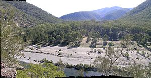
The Macleay River flows through amazing gorges and past beautiful waterfalls. You can see these natural wonders in Cunnawarra National Park and Oxley Wild Rivers National Park. Finally, the river reaches its mouth at the Tasman Sea, close to South West Rocks. The river drops about 460 meters (1,509 feet) over its 298-kilometer (185-mile) journey.
River Crossings and Flooding
The river flows right next to the city of Kempsey. Near Frederickton, the Pacific Highway crosses the river on the Macleay River Bridge. This bridge is called Yapang gurraarrbang gayandugayigu in the Dhanggati language. When it opened in 2013, it was the longest road bridge in Australia. The North Coast railway line also crosses the river.
The Macleay River can sometimes flood the Kempsey area. These floods can cause a lot of damage. During very big floods, the Macleay River can hold over 200,000 gigaliters (53 billion US gallons) of water.
History of the Macleay River
Traditional Owners of the Land
The Dunghutti people are the original Aboriginal Australian custodians of the land around the Macleay River. Their descendants mostly live in the lower Macleay River area today. Scientists have found old Aboriginal camp sites on the higher parts of the Macleay and Apsley rivers. This shows that people have lived here for a very long time.
Early European Exploration
In 1820, John Oxley explored the river but didn't go far enough upstream. He missed seeing the amazing forests and rich land. The river was first called the New River, based on descriptions from Aboriginal people. In 1826, Captain Wright explored the river up to Belgrave Falls. This was a series of rapids west of where Kempsey is now.
The river was then called Wrights River. In 1827, Major Archibald Clunes Innes sent the first group of government workers to cut Australian red cedar trees here.
Cedar Cutting and Settlement
More cedar camps were set up on the Macleay in the 1830s. The area also became a hiding place for people who had escaped from prison. By 1841, about 200 cedar cutters were working on the river. Sometimes there was fighting and stealing of logs. In 1842, the demand and prices for cedar dropped. Cedar cutting continued in the smaller rivers that flow into the Macleay.
When Europeans first arrived around the 1820s, the river mouth was near Grassy Head. It was almost a mile wide with a sandbar in the middle. The small town of Stuarts Point was built on the river to serve arriving ships.
Changing the River Mouth
The coast from South West Rocks to Grassy Head is a wide delta with many channels connected to the river. Around 1885, a British engineer named John Coode gave advice on improving rivers and ports in Australia, including the Macleay. The government made plans to improve the river mouth. Coode thought it best to improve the existing entrance.
However, in 1893, a flood created a new opening near South West Rocks. The government decided to improve this "New Entrance" instead. Work on the new entrance started in April 1896. They made the channel better and added training walls. A new pilot station was built in 1902, which helped establish the town of South West Rocks. The work finished in 1906. Today, the old river mouth has filled with sand, leaving Stuarts Point on a dead-end part of the river.
How the River Got its Name
The river was known by different names like Wright River, Trail River, New River, and McLeay River. It was finally named the Macleay River to honor Alexander Macleay. He was a Scottish scientist and a colonial secretary of New South Wales, and also Major Innes's father-in-law.
See also
 In Spanish: Río Macleay para niños
 | William M. Jackson |
 | Juan E. Gilbert |
 | Neil deGrasse Tyson |


