
Apsley River (New South Wales) facts for kids
Quick facts for kids Apsley River |
|
|---|---|

Apsley River in Oxley Wild Rivers National Park
|
|
| Country | Australia |
| State | New South Wales |
| IBRA | New England Tablelands |
| District | Northern Tablelands |
| Local government area | Walcha |
| Physical characteristics | |
| Main source | Tia Range, Great Dividing Range west of Tia 1,260 m (4,130 ft) |
| River mouth | confluence with the Macleay River southwest the locality of Lower Creek 190 m (620 ft) |
| Length | 168 km (104 mi) |
| Basin features | |
| River system | Macleay River catchment |
| Tributaries |
|
| Waterfalls | Apsley Falls |
| National park | Oxley Wild Rivers NP |
The Apsley River is a river in New South Wales, Australia. It's a perennial stream, meaning it flows all year round. It's part of the larger Macleay River system and is found in the Northern Tablelands area.
Contents
River's Journey and Features
The Apsley River starts high up in the Tia Range. This area is part of the Great Dividing Range. Its source is about 11 kilometres (7 miles) west of Tia. It's also about 29 kilometres (18 miles) south of Walcha.
The river flows north through the town of Walcha. Then it dramatically spills over the Apsley Falls. The water drops about 27 metres (89 feet) into the Apsley Gorge. It continues its journey to join the Macleay River. This meeting point is about 24 kilometres (15 miles) southwest of Lower Creek.
The Apsley River has seven smaller rivers and creeks joining it. These are called tributaries. Important ones include the Tia River and Yarrowitch River. The river drops a total of 1,070 metres (3,510 feet). It flows for about 168 kilometres (104 miles).
Deep Gorges and Waterfalls
The Apsley River, along with the Macleay River, has carved deep valleys. These valleys are cut into very old rocks. This has created many amazing gorges and waterfalls. You can see these on or near the Apsley River. They are all found within the Oxley Wild Rivers National Park.
Plants and Animals
The Apsley and Macleay Gorges are special. They are where plants from the moist coast meet plants from the dry west. About 950 different native plant types have been found here. Some of these plants are rare or endangered. For example, the gorge wattle is a rare plant that mostly grows in these gorges. You might also spot epiphytic orchids. These are orchids that grow on trees.
The entire Apsley River flows within the Walcha Shire area. It is also completely within Vernon County.
Many interesting animals live in the warmer, lower parts of the Apsley River. These include Dingos, wild horses, carpet pythons, goannas, and feral pigs.
River's History
The land around the Apsley River has a rich history. The traditional owners are the Aboriginal people. These include the Ngayaywana and Dyangadi nations. Scientists have found old Aboriginal camp sites. These are on the higher ground near the Apsley and Macleay Rivers.
European Exploration
In 1818, an explorer named John Oxley camped by the Apsley River. This was very close to where Walcha town is today. He was on his way to the coast. A stone marker now shows where he camped. Oxley named the river after The Lord Apsley. Lord Apsley was a government official in charge of colonies.
Oxley wrote about his visit in his diary:
"We halted in a fine and spacious valley ... watered by a fine brook, and at a distance of a mile we saw several fires at which appeared many natives."
Early Industries and Changes
Before 1860, people were cutting Australian red cedar trees. These trees grew in the rainforests of the area. You might still see some red cedar trees in the more remote parts of the river's tributaries.
For many years, the "Mill Hole" in the Apsley River was a popular swimming spot. It was above the Fitzroy Street bridge in Walcha. This changed when the Walcha and District War Memorial Baths opened in 1970.
In 1981, there was a plan to build a large power project on the Apsley River. This project was meant to store energy for busy times. However, the plan was stopped. Instead, a study suggested creating a large national park. In 1986, the Oxley Wild Rivers National Park was officially created. Its goal was to protect nature, cultural history, and encourage tourism.
Community Efforts
The Lower Apsley River Landcare Group started in 1993. Their aim was to improve the health of the riverbanks. This group covers a large area of about 300 square kilometres (116 square miles). It stretches between Walcha and the Oxley Wild Rivers National Park. By 2008, the group had planted 320,000 trees. Most of these trees were growing well.
In 2007, a new bridge was built over the Apsley River in Walcha. The old wooden bridge was only one lane. The new bridge has two lanes and a path for people walking.
Flooding in Walcha
The Apsley River has flooded the town of Walcha several times. Major floods happened in 1893, 1935, 1941, and 1952. The worst flood for Walcha was on January 12, 1962. During this flood, 40 businesses and 39 homes were underwater. The damage was very costly.
Flood Protection
After the 1962 flood, the Walcha Council decided to build flood protection. This project was approved in 1967. By 1973, the flood protection system was almost finished. This included building levee banks. Levee banks are walls built along the river to hold back water. Since these banks were built, the town of Walcha has not flooded again.
The Apsley River did flood on November 28, 2008. This caused a lot of damage to farms. Many animals were lost. However, the levee banks successfully protected the town of Walcha from the floodwaters.
Images for kids
-
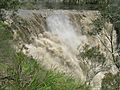
Apsley Falls during a flood.


