Yarrowitch River facts for kids
Quick facts for kids Yarrowitch River |
|
|---|---|

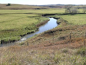
Yarrowitch River near the Oxley Highway
|
|
| Country | Australia |
| State | New South Wales |
| Region | New England Tablelands (IBRA), Northern Tablelands |
| Local government area | Walcha |
| Physical characteristics | |
| Main source | Great Dividing Range near Yarrowitch 1,100 m (3,600 ft) |
| River mouth | confluence with the Apsley River near Tia 283 m (928 ft) |
| Length | 62 km (39 mi) |
| Basin features | |
| River system | Macleay River catchment |
| Tributaries |
|
| National parks | Mummel Gulf NP, Oxley Wild Rivers NP |
The Yarrowitch River is a stream that flows all year round in the Northern Tablelands area of New South Wales, Australia. It is part of the larger Macleay River system.
Where the Yarrowitch River Flows
The Yarrowitch River starts high up in the Mummel Gulf National Park. This park is on the northern side of the Great Dividing Range. The river begins southwest of a place called Yarrowitch.
From Mountains to Other Rivers
The river generally flows towards the north-northeast. Along its way, another river called the Warnes River joins it. The Yarrowitch River then meets and flows into the Apsley River. This meeting point is southwest of Tia.
Amazing Waterfalls and Farmland
The Yarrowitch River drops a lot in height as it flows. It falls about 822 meters over its 62-kilometer journey. One exciting part of its path is the Yarrowitch Falls, which are located in the Oxley Wild Rivers National Park. In the middle parts of the river, it flows through rich farmland. This land is mainly used for raising livestock, especially beef cattle.
 | Delilah Pierce |
 | Gordon Parks |
 | Augusta Savage |
 | Charles Ethan Porter |

