Oxley Creek facts for kids
Quick facts for kids Oxley |
|
|---|---|

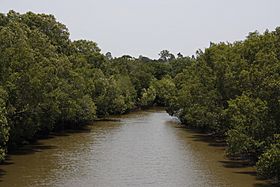
Oxley Creek seen from Sherwood Road
|
|
|
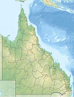
Location of the Oxley Creek mouth in Queensland
|
|
| Country | Australia |
| State | Queensland |
| Region | South East Queensland |
| Physical characteristics | |
| Main source | Mount Perry near Flinders Peak Mount Perry, Scenic Rim 190 m (620 ft) |
| River mouth | confluence with the Brisbane River Tennyson 1 m (3 ft 3 in) 27°31′26″S 152°59′41″E / 27.52389°S 152.99472°E |
| Length | 70 km (43 mi) |
| Basin features | |
| River system | Brisbane River |
| Basin size | 260 km2 (100 sq mi) |
The Oxley Creek is a long stream in Queensland, Australia. It is also known by its traditional name, Benarrawa, in the Turrbal language. This creek is a tributary, meaning it flows into a larger river. Oxley Creek joins the Brisbane River in the suburban area of Brisbane.
The creek starts in the low hills of the Scenic Rim Region. Water from a large area, called a catchment area, flows into Oxley Creek. This catchment area is about 260 square kilometres (100 square miles). The creek then flows through parts of Logan City and into Brisbane. Oxley Creek is the longest creek in Brisbane, stretching about 70 kilometres (43 miles). It is also the only sand-based creek in the city.
Contents
Where Does Oxley Creek Flow?

Oxley Creek begins on the northern side of Mount Perry. This mountain is located south of Ipswich in the Scenic Rim Region. From its start, the creek flows north for about 70 kilometres (43 miles). It eventually empties into the Brisbane River at Tennyson.
Many smaller streams, called tributaries, flow into Oxley Creek. These include Crewes Creek, Blunder Creek, and Rocky Water Holes Creek.
Natural and Urban Areas Along the Creek

The upper part of Oxley Creek is mostly natural. It has forested hills and land used for grazing animals. However, as the creek flows further, it passes through many developed areas. In the middle and lower parts, Oxley Creek flows through 28 suburbs in Brisbane. These include places like Algester, Corinda, and Forest Lake.
Large industrial areas are also found along the creek. These include Acacia Ridge and Rocklea. There are also water treatment plants near Oxley and Inala. Even Archerfield Airport is close to the creek's path.
Creek Crossings and Water Flow
The Ipswich Motorway and Logan Motorway both cross Oxley Creek. The creek is affected by tides from the ocean up to the Ipswich Motorway crossing. This means the water level rises and falls with the ocean tides.
In suburbs like Oxley and Corinda, the lower parts of the creek have a canoe trail. Houses, parks, and sports fields are built along its banks. These areas of the creek can sometimes flood, especially if there is heavy rain. This often happens when Stable Swamp Creek, one of its tributaries, overflows its banks near Rocklea.
History of Oxley Creek
The Yerongpan clan of the Turrbal people were the traditional owners of the land around Oxley Creek. They used the creek's natural resources for food and other needs. They called the creek Benarrawa in their language.
Naming the Creek
The creek was named after John Oxley. He was an explorer who surveyed the area in December 1823. At first, Oxley called it "Canoe Creek." This name was given because three shipwrecked Europeans, Thomas Pamphlett, John Finnegan, and Richard Parsons, found two canoes there. They used one canoe to cross the creek. By 1825, the creek became known as Oxley Creek.
Early Uses and Development
As early as 1828, hoop pine trees were cut down near the mouth of Oxley Creek. This timber was used for the Moreton Bay penal settlement. In 1852, the first public bridge was built over the creek. This bridge was for a road that led to Ipswich. By the 1860s, timber cutters from Brisbane were working in the Oxley Creek flood plain. At that time, the creek and its smaller streams were surrounded by thick bushland and rainforest.
Protecting the Creek Today
In 2006, the Brisbane City Council started a group called the Lord Mayor's Oxley Creek Catchment Taskforce. Their goal was to help clean up and protect the creek. This taskforce even won an award in 2012 for their work.
In 2017, a new organization called Oxley Creek Transformation was created. The Brisbane City Council supports this group with a lot of money over 20 years. Their aim is to turn the Oxley Creek area into a large parkland. They want to reduce the effects of industry on the creek and make the area better able to handle floods. They also plan to create new green spaces. Some of their main projects include:
- A 20-kilometre (12-mile) walking and recreation trail.
- A new nature park in Larapinta.
- A famous birdwatching spot at Oxley Creek Common.
- A regional park at Archerfield Wetlands with a visitor centre.
Environmental Challenges
The water quality of Oxley Creek has been affected by many things. These include houses and factories being built, sewage, and land clearing. Sand mining in the area has also changed the creek's flow.
Main Issues Affecting the Creek
Some of the biggest environmental problems for the creek are:
- A fast increase in people living nearby and new buildings.
- Changes in how the creek flows, which causes the banks to wear away (erosion).
- Water quality getting worse.
- More noise and vehicle traffic.
- Problems with getting rid of waste.
- Invasive plants and animals taking over native bushland.
- Managing industries that take materials from the land.
- The everyday actions of people living and working in the area.
Efforts to Improve Water Quality
Local councils and community groups have worked to reduce dirt and mud entering the creek. They do this by planting trees and other plants. By 2008, tests showed that the creek's water quality had improved. However, the rating went down again in the following years.
During the 2010–2011 Queensland floods, dirty water from a waste treatment centre was released into Oxley Creek. Levels of bacteria in the water were much higher than normal. After the floods, it took a long time to clean up the creek. By January 2012, a lot of money had been spent to remove dangerous materials and debris from the creek's banks.
Some local people want a special structure called a groyne built at the mouth of the creek. This would help the water flow better and reduce mud. Others want sand mining to stop because it creates a lot of silt (fine dirt) in the water.
 | Lonnie Johnson |
 | Granville Woods |
 | Lewis Howard Latimer |
 | James West |


