
Oxley, Queensland facts for kids
Quick facts for kids OxleyBrisbane, Queensland |
|||||||||||||||
|---|---|---|---|---|---|---|---|---|---|---|---|---|---|---|---|

Roundabout at Oxley central, 2009
|
|||||||||||||||

Oxley
Location in Queensland
|
|||||||||||||||
| Population | 9,100 (2021 census) | ||||||||||||||
| • Density | 1,264/km2 (3,270/sq mi) | ||||||||||||||
| Established | 1851 | ||||||||||||||
| Postcode(s) | 4075 | ||||||||||||||
| Area | 7.2 km2 (2.8 sq mi) | ||||||||||||||
| Time zone | AEST (UTC+10:00) | ||||||||||||||
| Location | 14.8 km (9 mi) SW of Brisbane CBD | ||||||||||||||
| LGA(s) | City of Brisbane (Jamboree Ward, Moorooka Ward, Tennyson Ward) |
||||||||||||||
| State electorate(s) |
|
||||||||||||||
| Federal Division(s) | Moreton | ||||||||||||||
|
|||||||||||||||
Oxley is a suburb located in the south-west of Brisbane, Queensland, Australia. It's about 14.8 kilometers (9.2 miles) from the center of Brisbane. Oxley has a mix of homes and businesses. In 2021, about 9,100 people lived in Oxley.
Contents
Exploring Oxley's Landscape
Oxley is bordered by the Brisbane River to the north. Oxley Creek flows along its eastern side. The eastern parts of Oxley are flat floodplains. These areas can experience major floods and flash-flooding. The western parts of the suburb have rolling hills. These hills have soils that contain a lot of clay.
Oxley is crossed by the Ipswich Motorway. This road connects Oxley to Rocklea in the east. It also links to Darra in the west. Oxley Road goes north to Corinda. South of the Ipswich Motorway, it becomes Blunder Road and leads to Durack. Seventeen Mile Rocks Road connects Oxley to Seventeen Mile Rocks and Darra in the west. The Brisbane River separates Oxley from Fig Tree Pocket.
What Can You Find in Oxley?
Oxley has two golf courses. There is also a golf driving range. The Oxley Golf Course is at 290 Boundary Road. The Corinda Golf Course is on Cliveden Avenue. Brisbane Boys' College now owns the Corinda course and the driving range. They use them as their playing fields.
Oxley is also home to the Canossa Private Hospital. The Queensland Police Service's training academy is here too.
A former brick quarry site on Douglas Street has been turned into new homes. This quarry was once owned by Brittain Bricks. For many years, it was a brickworks. It got its clay directly from nearby pits. After the brick production stopped, a tall chimney remained. In the mid-1990s, this chimney was removed. It was attracting lightning strikes.
Oxley's Past: A Journey Through Time
The area now known as Oxley has been important to Aboriginal people for thousands of years. The banks of Benarrawa, the original name for Oxley Creek, were home to clans like the Yerongpan and Chepora. These groups were part of the Yugara and Yugarabul peoples. The area was surrounded by thick forests and had lots of wildlife. This included kangaroos (murri), koalas (dumbirrbi), turtles (binkin), and black swans (marutchi).
This area was also a travel route (kul'gun) for other clans. They used many traditional ways to manage the land and hunt. This included firestick farming. They also used clever fishing methods like traps and natural ways to stun fish.
How Oxley Got Its Name
Oxley Creek was named after John Oxley. He first explored the creek in December 1823. Oxley first called it Canoe Creek. This was because three shipwrecked Europeans found two canoes there. These men were Thomas Pamphlett, John Finnegan, and Richard Parsons. They had been shipwrecked on Stradbroke Island. At Oxley Creek, they used one canoe to cross the river. They then traveled downstream. In 1925, Edmund Lockyer surveyed the Brisbane River. He named it Oxley Creek to honor John Oxley. The suburb itself takes its name from the creek.
Early Days and Growth
The first land sale in what is now Oxley happened in 1851. Oxley used to be much larger. It included suburbs like Chelmer, Graceville, and Corinda to the north. It also stretched south into Willawong and Durack.
The first residential land was divided into smaller plots in 1864. This was near Douglas Street. A railway connected Oxley to Brisbane. However, the road to Ipswich was key to the suburb's early growth.
Thomas Boyland leased a large part of Oxley in the early 1850s. This area was known as Boyland's Pocket. Later, this land was divided into small farms. This started around the 1860s.
Oxley was a stop for the Cobb & Co coach route. These coaches traveled west to the Darling Downs. The first hotel in Oxley was built in 1860. It was near Oxley Creek, on a small hill near Factory Road. The hotel attracted other businesses. It also offered food and drinks to travelers between Brisbane and Ipswich. This hotel became known for late-night drinking and dancing. It had to be moved several times because of floods. But this did not stop the owner. By 1892, a brick hotel was built. It was on the corner of Oxley Road and Ipswich Road. A public bar is still open at this site today.
By the late 1860s, Oxley had grown quite a bit. It had a hotel, a racecourse, a post office, and churches.
A church made of bark was built in 1870. It was on the corner of Oxley Road and Bannerman Street. In 1891, a wooden building was added. It was used for Anglican and Presbyterian services. The church closed in the 1920s. The 1891 building was moved to Sherwood. It became part of a blacksmith's shop.
In 1869, a special floating sugar mill was used in Oxley Creek. It was called the Walrus. It crushed sugarcane.
Oxley East Non-Vested School opened on January 31, 1870. In 1881, the government took it over. It was renamed Oxley State School. A pre-school opened there on September 5, 1977.
In the 1870s, small farms started to grow different things. They also began dairying and processing bacon. A small creamery opened in 1873. It was likely near Factory Road in Oxley's south-east.
By 1873, there were five churches in Oxley. These included Anglican, Congregational, Presbyterian, Baptist, and Methodist churches.
In 1874, the Oxley railway station opened. It was on the Main Line railway from Brisbane to Ipswich. This led to a second land subdivision in 1876. It was called the Township of Oxley. This area was centered around the train station. It had 140 plots of land. The lower plots often flooded. In the same year, the first police station was built. Dairying became common in the area during the 1890s. The 1893 Brisbane flood stopped new housing in lower Oxley for many years. William Brittain moved his brick making business to Douglas Street in 1899.
In 1879, the Yeerongpilly Division was created. In 1891, parts of Yeerongpilly Division became Sherwood Division. This became a Shire in 1903 and included Oxley. In 1925, the Shire of Sherwood joined the City of Brisbane.
Mrs Janet O'Connor Girls School was open from 1885 to 1920.
Duporth Ladies School moved to Oxley from Brisbane in 1888. This school's site later became an Ursuline Convent (1924–57). It then became the Canossa Hospital (1965).
In June 1889, "Oxley Station Terraces Estate" was advertised for sale. It had 145 plots of land. A map showed the estate was close to the river. It was also only a five-minute walk from Oxley Station.
Oxley in the 1900s
A sailing club was started in 1902.
By 1904, a "Bacon Factory" was set up. It made bacon, cheese, ham, and other small goods.
In 1911, the Oxley police station moved. It moved to where the police academy is now. This was because of regular flooding.
The Oxley Progress Association was started in 1917. They built a small hall on Station Road in 1924. This group also helped set up the Oxley War Memorial. This community group was still active in the early 1990s. At that time, a cement works near Oxley planned to expand. With the help of the Oxley Progress Association, residents stopped this plan. In the 1960s, the group helped create Queensland's Clean Air Act.
The Oxley war memorial was opened in 1920. It was moved in 1980. This memorial was built by F. Williams & Co. It cost about £110. It is made of sandstone and marble. It honors those from the area who died in World War I. This memorial is listed on the Queensland Heritage Register.
The Oxley Golf Club started in 1928. Its golf course officially opened on March 23, 1929.
A Methodist church was built in 1930.
On January 9, 1938, a new Apostolic church opened. Apostle Emil Zeike, head of the Apostolic Church of Queensland, dedicated it. The church is on Irwin Street.
The Oxley Scout Group was formed in 1951. In 1955, the Oxley fire station was established.
An ambulance station was built in Oxley in 1961. But it moved to Durack in 2002.
Oxley State High School opened on January 24, 1966. On January 1, 1994, it was renamed Oxley Secondary College. It closed on December 31, 2000. Centenary State High School in Jindalee took its place. However, Oxley is not in Centenary State High School's area today. Oxley Secondary College was off Clivenden Avenue.
The bus and train interchange at Oxley station was built in 1977.
Oxley in the 2000s
The 2010–2011 Queensland floods covered many properties in Oxley. This included main roads like Oxley Road, Blunder Road, and the Ipswich Motorway. At least ten smaller roads also flooded. The Bunnings warehouse on Blunder Road flooded. It was closed for two months.
On July 17, 2013, a new Woolworths store opened. It is on Oxley Station Road.
The 2022 floods in Brisbane also affected parts of Oxley. The Bunnings warehouse flooded again. In August 2022, it was announced that the ground-level building would not reopen. Instead, a new three-level building will replace it. The ground floor will be for car parking. The two upper levels will be for shops. These will be above future flood levels. Bunnings believes this design will let them reopen within 24 hours after a flood. This is much faster than months. This design has worked well at their Bundamba store. That store recovered from the 2022 floods within 24 hours.
Who Lives in Oxley?
In 2011, Oxley had 7,291 people. About 51.1% were female and 48.9% were male. The average age was 34 years old. This is three years younger than the Australian average. About 64.4% of people in Oxley were born in Australia. This is a bit lower than the national average of 69.8%.
Other countries of birth included Vietnam (4.3%), England (3.7%), New Zealand (3.3%), Philippines (1.4%), and India (1.2%). About 72.1% of people spoke only English at home. Other popular languages were Vietnamese (6.1%), Hindi (1%), Arabic (1%), and Mandarin (1%).
In 2016, Oxley had 8,336 people. By 2021, the population grew to 9,100 people.
Important Places in Oxley
Oxley has some places listed for their history. These are called heritage-listed sites.
- The Fort, 199 Fort Road
- Oxley War Memorial, 1218 Oxley Road
Oxley's Businesses
PGH Bricks & Pavers has one of its two Queensland factories in Oxley. This is because there is a good supply of clay in the area.
Learning in Oxley
Oxley State School is a government primary school. It teaches students from Prep to Year 6. It is for both boys and girls. The school is on Bannerman Street. In 2018, it had 475 students.
There is no high school directly in Oxley. The closest government high schools are Corinda State High School in Corinda (to the north). Also, Glenala State High School in Durack (to the south) is nearby.
The Queensland Police Academy has its Brisbane campus in Oxley. It is located at 92 Rudd Street.
Community Facilities
Canossa Private Hospital is at 169 Seventeen Mile Rocks Road. It also has aged care services and a retirement village.
The Oxley Creek Wastewater Treatment Plant is a sewage treatment plant. It is at the northern end of Donaldson Road. This plant cleans wastewater. The treated water is then released into the Brisbane River.
Local Amenities
The Oxley branch of the Queensland Country Women's Association meets at the QCWA Oxley Hall. This hall is at 76 Lincoln Street.
There are several churches in Oxley:
- Oxley-Darra Uniting Church, 114 Oxley Station Road
- Oxley Apostolic Church, 24 Irwin Terrace
The Oxley Samoan Church meets at Goodna State School in Goodna. It is part of the Wesleyan Methodist Church of Australia.
Canossa Retirement Village is at 11 Fort Road. It is next to Canossa Private Hospital.
The Archerfield Wetlands is a large green area. It covers about 150 hectares (370 acres). It is located in the suburbs of Durack, Willawong, Rocklea, and Oxley. It is along the Oxley Creek corridor. It also borders the Archerfield Airport.
The main entrance to the wetlands is at Archerfield Wetlands District Park. This park is at 455 Bowhill Road in Durack. This park used to be a wastewater treatment plant. Now, it has indoor and outdoor community spaces. There are playgrounds with water features. You can also find picnic and barbeque areas. It is also the starting point for walking and cycling trails. These trails go through the larger wetlands. There is another entrance to the trails at 30 Gleneagles Crescent, Oxley.
Getting Around Oxley
The Ipswich Motorway goes through Oxley. The train from Brisbane to Ipswich has a station at Oxley. Buses connect Oxley to many other suburbs. A CityExpress bus stop on Blunder Road links the Inala Plaza bus station to the city center. It uses Ipswich Road. Oxley Road connects the Ipswich Motorway to Indooroopilly. It crosses the Walter Taylor Bridge.
Images for kids
-

Ipswich Motorway looking west at Oxley Road roundabout, Oxley, 2019
-
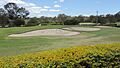
Oxley Golf course, bunkers at the 9th hole, 2014
-
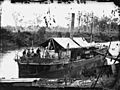
Travelling sugar mill, Walrus, circa 1870
-
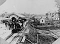
Steam engine at Oxley Railway Station, 1876
-
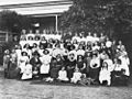
Ladies of Duporth Private School, Oxley, 1913
-
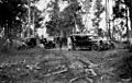
Motor vehicles in the bush, 1930
-
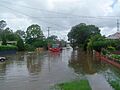
Oxley Station Road about 17 hours before the 2011 Queensland flood peak
-
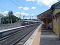
Oxley railway station, 2009
-
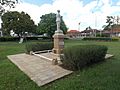
Oxley War Memorial, 2014


