Willawong, Queensland facts for kids
Quick facts for kids WillawongBrisbane, Queensland |
|||||||||||||||
|---|---|---|---|---|---|---|---|---|---|---|---|---|---|---|---|

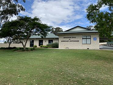
Kingdom Hall of Jehovah's Witnesses, Willawong, 2022
|
|||||||||||||||
| Population | 145 (2021 census) | ||||||||||||||
| • Density | 17.26/km2 (44.7/sq mi) | ||||||||||||||
| Established | 1970 | ||||||||||||||
| Postcode(s) | 4110 | ||||||||||||||
| Area | 8.4 km2 (3.2 sq mi) | ||||||||||||||
| Time zone | AEST (UTC+10:00) | ||||||||||||||
| Location | 17.3 km (11 mi) S of Brisbane CBD | ||||||||||||||
| LGA(s) | City of Brisbane (Moorooka Ward) |
||||||||||||||
| State electorate(s) | Algester | ||||||||||||||
| Federal Division(s) | Oxley | ||||||||||||||
|
|||||||||||||||
Willawong is a small suburb located in the southern part of Brisbane, Queensland, Australia. It is part of the City of Brisbane area. In 2021, about 145 people lived there.
Contents
Exploring Willawong's Location
Willawong is about 17.3 kilometers (10.7 miles) south of the center of Brisbane.
Two creeks, Oxley Creek and Blunder Creek, mostly form the edges of Willawong. A railway line connecting Sydney and Brisbane runs along the eastern side of the suburb.
Willawong's Past: A Brief History
Willawong became an official suburb in 1970. Its name comes from an Aboriginal word meaning 'where two creeks meet'.
In 1974, a big flood hit Brisbane, and most of Willawong was covered in water. Later, in 1983, people living in Willawong and nearby areas started a campaign. They wanted to stop companies from digging for sand in the area.
Willawong also used to have a place where toxic waste was stored. This site was closed down in 1998.
Who Lives in Willawong?
In 2011, Willawong had 192 residents. About 45.8% were female and 54.2% were male. The average age of people in Willawong was 40 years old. This was a bit older than the average age for all of Australia.
Most people (59.8%) living in Willawong were born in Australia. Other common birthplaces included Taiwan (9.3%), Vietnam (5.2%), and England (4.6%).
About 62.1% of people spoke only English at home. Other languages spoken included Vietnamese (11.8%) and Mandarin (7.7%).
By 2016, the population of Willawong had changed to 177 people. In 2021, the number of residents was 145.
Learning and Schools Near Willawong
There are no schools directly inside Willawong. However, there are several schools nearby for students.
- Primary Schools: The closest primary schools are Acacia Ridge State School and Watson Road State School, both in Acacia Ridge. Durack State School in Durack and Inala State School in Inala are also close.
- Secondary Schools: For high school students, Glenala State High School in Inala and Calamvale Community College in Calamvale are the nearest options.
Important Places and Services
Willawong has some useful facilities for its residents and the wider Brisbane area.
Willawong Resource Recovery Centre
The Brisbane City Council runs a resource recovery center at 360 Sherbrooke Road. This is a place where people can take their general rubbish, garden waste, and items to be recycled.
Brisbane's Bus Depot
A large bus depot for Transport for Brisbane is located at 399 Sherbrooke Road. This site is about 6 hectares (15 acres) in size. It is Brisbane's biggest bus depot. It can hold over 200 buses and has areas for refueling, fixing vehicles, offices, and places for staff to park and relax.
Community and Green Spaces
Willawong is home to several community places and is close to a large natural area.
Places of Worship
- The Kingdom Hall of Jehovah's Witnesses is located at 174 Learoyd Road.
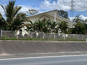
- The Congregational Christian Church of Samoa is at 228 Learoyd Road. It is also known as EFKS Southwest Brisbane. EFKS stands for Ekalesia Fa'apotopotoga Kerisiano Samoa, which means Congregational Christian Church of Samoa. Above the entrance, there are Samoan words, Puna O Le Olataga, which mean Source of Salvation.
Archerfield Wetlands: Nature's Playground
Even though it's called Archerfield Wetlands, this large green area is actually spread across several suburbs, including Durack, Willawong, Rocklea, and Oxley. It covers about 150 hectares (370 acres) along the Oxley Creek corridor. It also borders the Archerfield Airport.
The main entrance to the wetlands is through the Archerfield Wetlands District Park at 455 Bowhill Road in Durack. This park used to be a wastewater treatment plant. Now, it has many indoor and outdoor community areas, playgrounds with water features, and places for picnics and barbecues. It is also the starting point for walking and cycling trails that go through the larger wetlands.
 | Janet Taylor Pickett |
 | Synthia Saint James |
 | Howardena Pindell |
 | Faith Ringgold |


