Archerfield, Queensland facts for kids
Quick facts for kids ArcherfieldBrisbane, Queensland |
|||||||||||||||
|---|---|---|---|---|---|---|---|---|---|---|---|---|---|---|---|

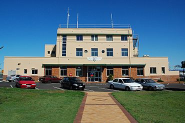
Archerfield Airport terminal, 2007
|
|||||||||||||||
| Population | 533 (2021 census) | ||||||||||||||
| • Density | 121.1/km2 (314/sq mi) | ||||||||||||||
| Postcode(s) | 4108 | ||||||||||||||
| Area | 4.4 km2 (1.7 sq mi) | ||||||||||||||
| Time zone | AEST (UTC+10:00) | ||||||||||||||
| Location | 15.4 km (10 mi) S of Brisbane CBD | ||||||||||||||
| LGA(s) | City of Brisbane (Moorooka Ward) |
||||||||||||||
| State electorate(s) | Algester | ||||||||||||||
| Federal Division(s) | Moreton | ||||||||||||||
|
|||||||||||||||
Archerfield is a suburb located in the southern part of Brisbane, Queensland, Australia. It's a place with a mix of different uses, like homes and businesses. In 2021, about 533 people lived here.
Contents
Exploring Archerfield's Location
Archerfield is bordered by Oxley Creek on its western side. To the east, you'll find Beaudesert Road.
Most of Archerfield's land is taken up by the Archerfield Airport. This airport is in the middle and southwest parts of the suburb. The rest of Archerfield is mostly industrial areas. There are also two smaller areas where people live, one in the north and one in the east.
Archerfield's Weather
Archerfield has seen some interesting weather! On August 8, 1995, it got very cold. The temperature dropped to 0 degrees Celsius. This was during a big cold snap across southern Queensland.
On the other hand, January 4, 2014, was super hot. The temperature reached 42.4 degrees Celsius. This was almost the hottest day ever recorded there. The record was set way back in 1940.
| Climate data for ARCHERFIELD AIRPORT | |||||||||||||
|---|---|---|---|---|---|---|---|---|---|---|---|---|---|
| Month | Jan | Feb | Mar | Apr | May | Jun | Jul | Aug | Sep | Oct | Nov | Dec | Year |
| Record high °C (°F) | 43.5 (110.3) |
41.8 (107.2) |
40.2 (104.4) |
34.9 (94.8) |
31.3 (88.3) |
28.9 (84.0) |
29.2 (84.6) |
35.7 (96.3) |
37.8 (100.0) |
39.4 (102.9) |
42.1 (107.8) |
41.2 (106.2) |
43.5 (110.3) |
| Mean daily maximum °C (°F) | 30.8 (87.4) |
30.3 (86.5) |
29.3 (84.7) |
27.1 (80.8) |
24.3 (75.7) |
21.8 (71.2) |
21.7 (71.1) |
23.2 (73.8) |
25.9 (78.6) |
27.4 (81.3) |
28.8 (83.8) |
29.8 (85.6) |
26.7 (80.1) |
| Mean daily minimum °C (°F) | 20.8 (69.4) |
20.5 (68.9) |
18.8 (65.8) |
15.4 (59.7) |
12.0 (53.6) |
9.7 (49.5) |
8.1 (46.6) |
8.3 (46.9) |
11.7 (53.1) |
14.8 (58.6) |
17.5 (63.5) |
19.3 (66.7) |
14.7 (58.5) |
| Record low °C (°F) | 13.7 (56.7) |
14.2 (57.6) |
10.1 (50.2) |
5.3 (41.5) |
1.1 (34.0) |
−0.8 (30.6) |
−2.5 (27.5) |
−1.8 (28.8) |
−0.4 (31.3) |
4.2 (39.6) |
7.2 (45.0) |
9.8 (49.6) |
−2.5 (27.5) |
| Average precipitation mm (inches) | 118.6 (4.67) |
138.7 (5.46) |
100.3 (3.95) |
51.9 (2.04) |
77.1 (3.04) |
57.1 (2.25) |
25.8 (1.02) |
34.8 (1.37) |
28.0 (1.10) |
71.0 (2.80) |
90.2 (3.55) |
122.3 (4.81) |
915.6 (36.05) |
| Average precipitation days | 10.9 | 12.8 | 13.1 | 9.6 | 9.2 | 9.1 | 6.7 | 6.1 | 6.8 | 8.9 | 9.7 | 11.0 | 113.9 |
| Average relative humidity (%) | 56 | 58 | 55 | 52 | 51 | 52 | 45 | 42 | 45 | 50 | 53 | 55 | 51 |
Archerfield's Past
Archerfield got its name from a huge farm called Archerfield pastoral station. This farm was bought in 1881 by Michael Durack. He was an important Australian farmer and pioneer.
The Archerfield Airport was once the main airport for Brisbane. The old building where people used to catch flights is still there. You can find it on the eastern side of the airfield. During World War II, the airport was used by the military. It helped support the war efforts in the Pacific region.
Who Lives in Archerfield?
| Historical population | ||
|---|---|---|
| Year | Pop. | ±% |
| 2001 | 576 | — |
| 2006 | 580 | +0.7% |
| 2011 | 510 | −12.1% |
| 2016 | 544 | +6.7% |
| 2021 | 533 | −2.0% |
In 2011, there were 510 people living in Archerfield. The average age of people in Archerfield was 37 years old. This was the same as the average age for all of Australia. Most people, about 64.5%, were born in Australia.
Other countries where people were born included India, England, the Philippines, New Zealand, and Fiji. Most people (67.4%) spoke only English at home. Other languages spoken included Vietnamese, Samoan, Hindi, Gujarati, and Greek.
By 2016, Archerfield's population grew a little to 544 people.
In 2021, the population was 533 people. About 64.2% of residents were born in Australia. Other common birthplaces included the Philippines, Vietnam, Afghanistan, Nepal, and New Zealand. English was spoken at home by 66.2% of people. Other languages included Vietnamese, Spanish, Hindi, Samoan, and Greek.
When it comes to religion, many people (35.8%) said they had no religion. Other common religions were Catholic (19.3%), Anglican (8.6%), and Islam (4.9%). The average age in Archerfield in 2021 was 39. This is just one year older than the average for both Queensland and Australia.
Special Places in Archerfield
Archerfield has some places that are listed for their special history. These are called heritage-listed sites. They include:
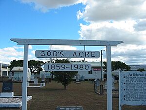
- God's Acre Cemetery: You can find this cemetery on Beatty Road, right in front of Archerfield Airport.
- Archerfield Second World War Igloos Complex: This is a group of buildings at 98-138 Kerry Road. They were used during World War II.
Schools Near Archerfield
There are no schools directly in Archerfield itself. But there are primary schools nearby in other suburbs. These include:
- Rocklea State School in Rocklea (to the north)
- Coopers Plains State School in Coopers Plains (to the east)
- Acacia Ridge State School in Acacia Ridge (to the south)
For high school, students can go to:
 | Calvin Brent |
 | Walter T. Bailey |
 | Martha Cassell Thompson |
 | Alberta Jeannette Cassell |


