
Mount Mee, Queensland facts for kids
Quick facts for kids Mount MeeQueensland |
|||||||||||||||
|---|---|---|---|---|---|---|---|---|---|---|---|---|---|---|---|

Panorama from Mount Mee lookout
|
|||||||||||||||

Mount Mee
Location in Queensland
|
|||||||||||||||
| Population | 519 (2021 census) | ||||||||||||||
| • Density | 6.697/km2 (17.35/sq mi) | ||||||||||||||
| Established | 1873 | ||||||||||||||
| Postcode(s) | 4521 | ||||||||||||||
| Elevation | 501 m (1,644 ft) | ||||||||||||||
| Area | 77.5 km2 (29.9 sq mi) | ||||||||||||||
| Time zone | AEST (UTC+10:00) | ||||||||||||||
| Location |
|
||||||||||||||
| LGA(s) | City of Moreton Bay | ||||||||||||||
| State electorate(s) | Glass House | ||||||||||||||
| Federal Division(s) | Longman | ||||||||||||||
|
|||||||||||||||
Mount Mee is a small town and area in the City of Moreton Bay, Queensland, Australia. It's known for its beautiful views and natural surroundings. In 2021, a count of the population (called a census) showed that 519 people lived in Mount Mee.
Contents
Exploring Mount Mee's Geography


Mount Mee is also the name of a mountain, sometimes called Bonnie Knob. It's located north of the town of Dayboro. This mountain is part of the D'Aguilar Range and rises about 498 meters (1,634 feet) above sea level. The main road, Brisbane–Woodford Road (also known as Mount Mee Road), goes right through the area from south to north.
A Look Back at Mount Mee's History
Early Days and Indigenous Heritage
The area around Mount Mee was originally known as Dahmongah by the local Aboriginal people. This word means "flying squirrel" or glider. The name Mount Mee might come from another local word, mia-mia, which means "a view" or "lookout". This name became official when the first school opened in 1899.
Settlers and the Timber Industry
New settlers started arriving in Mount Mee in 1873. Many came to cut down trees, especially the valuable red cedar timber. At first, the cut timber was sent to nearby towns like Caboolture and Woodford. Later, a sawmill was built in the town to process the wood locally. Large sawmills operated on the mountain until the last one closed in 1982.
Schools and Community Buildings
The first school, Dahmongah Provisional School, opened in 1884. It was renamed Mount Mee Provisional School in 1900 and became Mount Mee State School in 1909. It briefly closed in 1904 but reopened.
The Mount Mee Methodist Church was built in 1922. It was a "community church," meaning different Christian groups could use it. However, it closed in 2023 and is now for sale. The Mount Mee Public Hall, a place for community events, opened in 1933.
Farming and Local Government
In the early 1930s, a special tractor called a Linn tractor was used to move logs instead of animal teams. Over time, farming became very important to Mount Mee. Dairy farms and banana plantations were especially common.
Mount Mee was once part of the Caboolture area. In 2008, it became part of the larger Moreton Bay Region, which is now called the City of Moreton Bay.
Who Lives in Mount Mee?
In 2021, the population of Mount Mee was 519 people. The average age of people living there was 52 years old. This is a bit older than the average age for all of Australia, which is 38.
Most people (77.5%) living in Mount Mee were born in Australia. Other countries of birth included England (4.4%) and New Zealand (1.9%). Most people (87.5%) spoke only English at home. When asked about their family background, many people said their ancestry was English (43.9%) or Australian (36.2%). A small number of people (1.3%) were Aboriginal Australians or Torres Strait Islanders.
Mount Mee State Forest and Forest Reserve
Mount Mee State Forest and Forest Reserve is a protected natural area. It has different types of trees, including eucalyptus forests and small areas of rainforest. There are also plantations of Hoop Pine trees. This area is next to the Brisbane Forest Park.
The park is a great place for outdoor activities. It has six different walking tracks for you to explore. There are also two picnic grounds and a camping ground if you want to stay overnight. Many tracks are available for off-road driving.
Learning in Mount Mee
Mount Mee State School is a government primary school for students from Prep (the first year of school) to Year 6. It is located at 1368 Mt Mee Road. In 2021, the school had 53 students.
Mount Mee does not have any secondary schools (high schools). Students usually travel to nearby towns for high school. The closest government secondary school for students up to Year 10 is Woodford State School in Woodford. For students up to Year 12, options include Tullawong State High School in Caboolture and Kilcoy State High School in Kilcoy.
Community Spots and Services


The Moreton Bay City Council offers a mobile library service. This library on wheels visits near the Mount Mee Public Hall at 1352 Mount Mee Road. The council also helps manage the public hall with local volunteers.
The historic Mount Mee Community Church is located across the road from the hall at 1345 Mount Mee Road. It closed in 2023 and is now for sale. This church has great views from the mountain.
The Mount Mee Cemetery is a burial ground located at 1 Cemetery Road, off Settlement Road.
Fun Things to Do in Mount Mee
The Pitstop Cafe is a popular spot with amazing views. It also has a large collection of car and racing items and serves food.
If you love views, there are several lookouts in D'Aguilar National Park at Mount Mee:
- Falls Lookout
- Bulls Lookout
Both of these lookouts can be reached from the Falls Lookout Track, which starts from Neurem Road.
Images for kids
-
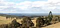
Panorama from Mount Mee lookout
-
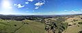
Aerial panorama from Mount Mee lookout. June 2023.
-
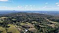
Mount Mee and surrounds from above. June 2023.
-
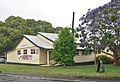
Mount Mee Public Hall, 2010
-
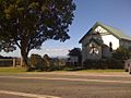
Mount Mee Community Church, 2010
