
Cleveland, Queensland facts for kids
Quick facts for kids ClevelandRedland City, Queensland |
|||||||||||||||
|---|---|---|---|---|---|---|---|---|---|---|---|---|---|---|---|

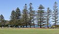
Norfolk Pines in G.J. Walter Park, Cleveland
|
|||||||||||||||

Cleveland
Location in Queensland
|
|||||||||||||||
| Population | 15,850 (2021 census) | ||||||||||||||
| • Density | 1,003/km2 (2,600/sq mi) | ||||||||||||||
| Established | 1850 | ||||||||||||||
| Postcode(s) | 4163 | ||||||||||||||
| Area | 15.8 km2 (6.1 sq mi) | ||||||||||||||
| Time zone | AEST (UTC+10:00) | ||||||||||||||
| Location |
|
||||||||||||||
| LGA(s) | Redland City | ||||||||||||||
| State electorate(s) | Oodgeroo | ||||||||||||||
| Federal Division(s) | Bowman | ||||||||||||||
|
|||||||||||||||
Cleveland is a town located on the coast in Queensland, Australia. It's part of the City of Redland. In 2021, about 15,850 people lived there.
Cleveland is an important transport hub. It connects the mainland to islands in Moreton Bay.
Contents
Exploring Cleveland's Location

Cleveland is on the western side of Moreton Bay. It's about 25 kilometers (15 miles) east-south-east of Brisbane. Brisbane is the capital city of Queensland.
The town has shops, homes, and industrial areas. It's also where the Redland City Council offices are. You can find many cultural places here too.
Raby Bay and Toondah Harbour
Raby Bay used to be an area with mangroves and mudflats. Now, it has been developed with canals and a marina. A marina is a place where boats are kept.
Toondah Harbour is where you catch ferries to North Stradbroke Island. These ferries carry both people and cars. The water here is naturally shallow. However, a channel called Fison Channel has been dug deeper. This allows the large car ferries to reach Dunwich on the island.
Wetlands and Wildlife
The area around Toondah Harbour has important coastal wetlands. These wetlands include sandbanks, mudflats, and mangroves. They are vital homes for many animals. You can find dugongs and turtles here. Many types of shorebirds also live here. Some of these birds, like the critically endangered eastern curlew, travel long distances.
Most of these wetlands are part of the Moreton Bay Ramsar site. A Ramsar site is a wetland of international importance.
Cassim Island
Cassim Island is north of Toondah Harbour. It has sandbanks and mangroves. The island helps protect the harbour from strong winds. It's named after William Cassim, an early hotel owner in Cleveland. This island is a great habitat for wading birds and other animals that live in mangroves.
Cleveland's Past: A Journey Through Time

Cleveland is the traditional land of the Koobenpul clan. They are part of the Quandamooka people.
There are different stories about how Cleveland got its name. Some say Captain James Cook named it in 1770. He might have named it after John Clevland, a navy secretary. Others believe surveyors in the 1840s named it. They might have honored William Vane, the first Duke of Cleveland. It's more likely the surveyors named it. Captain Cook didn't actually enter Moreton Bay.
Early European Settlement
From 1824 to 1842, European settlement was not allowed in the Brisbane area. This was because it was a penal colony. But Cleveland was first surveyed in 1840. In 1841, it was suggested as a good place for a seaport. A navigation beacon was set up at Cleveland Point in 1847.
In 1847, the government planned a new town. On December 13, 1850, Cleveland was officially declared a township. The first land was sold a year later. People bought land mostly around Cleveland Point. At that time, Cleveland Point was considered a possible main port. Brisbane's river had sand bars, making it hard for ships. Cleveland Point was also closer to the southern entrance of Moreton Bay.

However, in 1842, Governor Sir George Gipps visited Cleveland. When he got off his boat, he sank into the mudflats! He was so annoyed that he changed his mind. He suggested Ipswich as a better port. Also, several shipwrecks happened in the southern passage. This made ships use the longer but safer northern entrance. A fire at the Cleveland jetty also happened. All these things meant Cleveland didn't become a major port.
Growth and Changes
In 1852, the first big buildings were built. These included what is now the Grand View Hotel. The Old Courthouse was also built. Farms started to appear. A brickworks was built, and a wool store too. The first mail service to Cleveland began in 1861. The first school opened at the same time.
The wool store wasn't used much because Cleveland wasn't a major port. It was turned into a sawmill. This mill provided wood for a shipyard built at the Point. At this time, only about 270 people lived in Cleveland. Tourism grew when regular steamer services started in 1864.

The Cleveland Point Light (lighthouse) was built in 1864. It helped guide ships. It was replaced in 1969. At first, sugar cane was a popular crop. Later, fruits like passion fruit and strawberries became more popular.
A railway line connecting Brisbane to Cleveland was finished in 1889. This brought more tourists and new homes. Farming also grew in the area.
The area now called G.J. Walter Park became a public reserve in 1889. People used it for swimming, picnics, and relaxing. This park is an important local heritage site.

The railway line used to go all the way to Cleveland Point. The current Cleveland station was built later for passengers.
The Redlands area became known for growing excellent fruits and vegetables. Farmers grew strawberries, tomatoes, pineapples, and many other crops.
The first Methodist church services were held in Cleveland in 1908. The Cleveland Methodist Church opened in 1909. It later became the Cleveland Uniting Church in 1977. New church buildings were built over the years. The older buildings are now used as halls.

By the start of World War I, Cleveland's population was around 540 people.
In 1960, the train service to Cleveland stopped. It was brought back twenty years later. By then, Cleveland's population was over 5,000.
The Leslie Harrison Dam was completed. This allowed town water to be connected to Cleveland. Most of the town had water by 1970.
Building of the Raby Bay canal estate began in 1983. By 1992, Cleveland's population was almost 10,000. The current Cleveland Library opened in 1997.
Who Lives in Cleveland?
In 2016, Cleveland had 14,801 people. About 52.6% were female and 47.4% were male. The average age was 49 years old. This is a bit older than the national average of 38.
Most people (64.8%) living in Cleveland were born in Australia. Other common birthplaces included England (9.3%), New Zealand (5.8%), and South Africa (2.0%). Most people (86.3%) spoke only English at home.
By 2021, Cleveland's population had grown to 15,850 people.
Places of Historical Importance

Cleveland has several sites listed for their historical importance. These are called heritage-listed sites. They include:
- St Pauls Anglican Church on Cross Street.
- The Cleveland Pioneer Cemetery on Lisa Street.
- A very old Moreton Bay Fig tree outside 2014 Middle Street.
- GJ Walter Park on 240 Middle Street East.
- A huge banyan tree at 47-49 North Street.
- The Grand View Hotel at 49 North Street.
- The Old Cleveland Police Station at 1-11 Passage Street.
- The Old Cleveland Court House (now a restaurant) at 1 Paxton Street.
- The Cleveland War Memorial on Shore Street.
- Fernleigh, an early Cleveland building at 73 Shore Street East.
- The Cleveland Point Light on Shore Street North.
- The Cleveland Hotel (Cassim's Hotel) at 109 Shore Street North.
- Norfolk Island Pine Trees at 127 Shore Street North.
- The RSL Hall at 44-76 Smith Street.

Learning in Cleveland
Cleveland has several schools for different age groups:
- Cleveland State School is a government primary school. It teaches students from Prep to Year 6. It also has a special education program.
- Star of the Sea Primary School is a Catholic primary school. It also teaches students from Prep to Year 6.
- Cleveland District State High School is a government secondary school. It teaches students from Year 7 to Year 12. It also has a special education program.
- Australian Industry Trade College - Redlands is a private secondary school. It focuses on trades for students in Years 11 and 12.
Important Services and Places
Cleveland has several important services and places:
- The Redland Hospital includes a private hospital wing.
- The Cleveland Industrial Estate is where many businesses are located.
Fun Things to Do and See

Cleveland has many cultural places:
- The Redland Art Gallery shows different art exhibitions.
- The Redland Museum teaches about the local history.
- The Redland Performing Arts Centre hosts shows and events.
- The Cleveland Library is a great place to read and learn. It's run by the Redland City Council.
The Redlands branch of the Queensland Country Women's Association meets on Waterloo Street.
G.J. Walter Park is a large public park. It's on the coast north of Toondah Harbour. You can see Cassim Island from here.
Cleveland Showgrounds is home to the Redlands United Football Club. It also hosts many other events.
The Cleveland Uniting Church is on Passage Street.
Local Attractions
Some popular attractions in Cleveland include:
- Cleveland Point, a scenic spot.
- The historic Cleveland Point Light (lighthouse).
Events in Cleveland
Cleveland hosts some exciting events:
- The Cleveland Markets are held every Sunday morning on Bloomfield Street.
- RedFest is a big festival held at the Cleveland Showgrounds. It used to be called the Strawberry Festival.
Getting Around Cleveland

You can get to Cleveland by major roads like Finucane Road and Bloomfield Street.
The Cleveland railway station connects to Brisbane. It's part of the Queensland Rail City network.
In 2013, a train went past the end of the line at the station. It crashed into the toilet block. An investigation found that leaves, oil, and rain made the rails slippery. This might have been caused by a storm a few days before.
Community Discussions

In 2014, the Queensland Government suggested a large development. It was planned for the area between Toondah Harbour and Cassim Island. This included a marina for 800 boats.
Many people had discussions about these plans. On February 23, 2014, about 300 people gathered to talk about the plans. They were concerned about the development affecting G.J. Walter Park.
Architects and planners reviewed the proposal. They thought the plan was too big and risky. They suggested smaller developments. These could connect Raby Bay with Cleveland's town center and the ferry terminal.
On March 4, 2014, a petition with 1,211 signatures was given to the Queensland Parliament. It asked for the government's plans to be changed.
On March 19, the Redland City Council asked the Queensland Government to make changes. They suggested reducing building heights from 15 storeys to 10. They also suggested a 400-berth marina instead of 800.
In April 2014, the Redland City Council shared expert reports. These reports were used to prepare the proposed development plan.
On May 31, 2014, an approved development plan was released. It included a report on the 583 comments received during the public discussion period.
Images for kids
-
Norfolk Pines in G.J. Walter Park, Cleveland
