
Redland City facts for kids
Quick facts for kids Redland CityQueensland |
|||||||||||||||
|---|---|---|---|---|---|---|---|---|---|---|---|---|---|---|---|

Location within South East Queensland
|
|||||||||||||||
| Population | 159,222 (2021 census) (46th) | ||||||||||||||
| • Density | 296.392/km2 (767.65/sq mi) | ||||||||||||||
| Established | 1948 | ||||||||||||||
| Area | 537.2 km2 (207.4 sq mi) | ||||||||||||||
| Mayor | Jos Mitchell | ||||||||||||||
| Council seat | Cleveland | ||||||||||||||
| Region | South East Queensland | ||||||||||||||
| State electorate(s) |
|
||||||||||||||
| Federal Division(s) | Bowman | ||||||||||||||
 |
|||||||||||||||
| Website | Redland City | ||||||||||||||
|
|||||||||||||||
Redland City, also known as the Redlands, is a special area in South East Queensland, Australia. It is a local government area (LGA), which means it has its own local council that helps manage the community. Redland City is part of Greater Brisbane.
As of June 2021, about 159,222 people live here. Redland City stretches along the southern coast of Moreton Bay. It covers about 537.2 square kilometers (207.4 square miles). The city shares borders with City of Brisbane and Logan City. Its islands are north of the City of Gold Coast.
The Redlands became a city on March 15, 2008. Before that, it was a shire since 1949. A shire is a type of local government area. Redland City is mostly made up of suburban areas and coastal towns. It has many green spaces and bushland. There isn't one big city center like in some other places.
Some of the main suburbs include Capalaba, Cleveland, Victoria Point, Thornlands, and Redland Bay. Redland Bay gave the city its name because of its red, fertile soil. North Stradbroke Island and other smaller islands, like those in Southern Moreton Bay, are also part of the Redlands.
Contents
History of Redland City

The land that is now the Redlands was first home to Aboriginal peoples. These included the Jagera, Turrbal, and Quandamooka people. Many places in the area have names from Aboriginal languages. An old Aboriginal meeting place called a bora ring can be found at Mount Cotton.
The Quandamooka people are the traditional custodians of North Stradbroke Island. They have also claimed native title over many of the Redlands' islands and mainland areas. Jandai is one of the Aboriginal languages spoken on Stradbroke Island.
Europeans first came to the Redlands in the late 1700s. They were mapping Moreton Bay. James Cook saw Stradbroke Island. Matthew Flinders landed on Coochiemudlo Island in 1799. Later, Robert Dixon mapped and named much of the area.
In the 1840s, the town of Cleveland was considered to be a major port. It was thought it might replace Brisbane. However, it was not chosen because of sandbars and shipwrecks in the area. Governor George Gipps also gave a bad review during his visit in 1842.
On November 11, 1879, the Tingalpa Division was created to govern the area east of Brisbane. On May 30, 1885, the area around Cleveland formed its own Cleveland Division. These divisions became shires in 1903.
In 1925, a large part of the Shire of Tingalpa became part of the new City of Brisbane. On December 9, 1948, the Shire of Cleveland was renamed the Shire of Redland. Part of the Shire of Tingalpa joined it.
The 1900s saw a lot of population growth in the Redlands. This happened after the Cleveland railway line was built. Peel Island became a place for people with leprosy. North Stradbroke Island became important for sand mining. It is also linked to the Indigenous rights movement. Famous Aboriginal people like poet Oodgeroo Noonuccal and academic Aileen Moreton-Robinson lived there.
On March 15, 2008, Redlands officially became a city. In 2018, the Redland City Council started a campaign to call the city "Redlands Coast." This was to attract tourists to its 335 kilometers (208 miles) of coastline.
Geography of Redland City

Most people in Redland City live in the main urban areas. These include Capalaba, Cleveland, and Victoria Point. However, over 6,000 people live on islands in Moreton Bay. These islands are part of the city.
The islands include North Stradbroke, Coochiemudlo, and the Southern Moreton Bay Islands. The Southern Moreton Bay Islands are Karragarra, Lamb, Russell, and Macleay.
Tingalpa Creek starts on Mount Cotton. It forms the Leslie Harrison Dam. This creek also marks most of the city's western border.
Animals and Plants
Redland City is home to many well-known animals and plants. These include koalas, shorebirds that migrate, flying foxes, and scribbly gum forests. Over 1,700 other native species live here. Many of these are at risk because of population growth.
Problems like clearing land, building roads, pollution, and new developments threaten these species. The city also has Venman Bushland National Park. This park helps protect nature. There is also the Eprapah Scout environment training center.

In April 2013, the Redland City Council cleared some plants illegally near Moreton Bay. The government made them replant the area.
The number of koalas in the city has gone down a lot. In 2010, there were only about 2,000 koalas. This was a 65% drop since 1999. A group called the Koala Action Group has warned that building too many new areas will cause koalas to disappear.
The city's borders include important coastal wetlands in the Moreton Bay Ramsar site. These areas have tidal flats, mangroves, and seagrass beds. They are important homes for fish, crustaceans, and other animals.
- Large numbers of the threatened green turtle and loggerhead turtle live here.
- The dugong, a large sea mammal, is also found here.

- 43 types of shorebirds use this area. This includes 30 migratory bird species that travel through the East Asian–Australasian Flyway. These include the vulnerable eastern curlew and the grey-tailed tattler.
The freshwater systems in the Redlands are not as healthy as they should be. This was reported in 2013 and 2014.
Fire ants have been found in some Redland City suburbs. Areas like Sheldon and Mount Cotton are considered high-risk. They need special treatment to get rid of the ants.
Getting Around Redland City

Queensland Rail runs the Cleveland railway line. This train line connects the Redlands to Brisbane. It is part of the City network. The line goes through Brisbane suburbs like Cannon Hill and Wynnum. Then it crosses Tingalpa Creek into Redland City.
Five train stations serve the northern suburbs of the city: Thorneside, Birkdale, Wellington Point, Ormiston, and Cleveland. Cleveland is the last stop on the line.
The TransLink (South East Queensland) bus network is also very common in the Redlands. Bus stations at Capalaba and Victoria Point have regular buses. These buses go to places like Carindale, Eight Mile Plains, Loganholme, and the Brisbane CBD during busy times.
There are plans to extend the Eastern Busway to Capalaba bus station. This project was paused in 2011 but a new study started in 2022.
The Gateway Motorway and Pacific Motorway are west of the city in Brisbane. Major roads like Old Cleveland Road, Mount Gravatt-Capalaba Road, and Mount Cotton Road connect to these highways. They enter the Redlands from areas like Chandler, Burbank, and Cornubia.
Culture and Heritage

Redland City has important cultural places. These include the Redland Art Gallery, Redland Museum, and Redland Performing Arts Centre.
The city also has many heritage-listed sites. These are places that are important to history and culture.
- Many historic sites in Cleveland, such as the Cleveland Point Light (a lighthouse), the Old Cleveland Police Station, and the Grand View Hotel.
- The church, public hall, causeway, and public reserve in Dunwich on North Stradbroke Island.
- Whepstead Manor at Wellington Point.
- The Industrial Ruins on Macleay Island.
- The Ormiston House Estate and Fellmongery.
- Norfolk Island Pine Trees.
- Serpentine Creek Road Cemetery in Redland Bay.
Libraries
The Redland City Council runs public libraries. You can find them at Amity Point, Capalaba, Cleveland, Dunwich, Point Lookout, Russell Island, and Victoria Point. There is also a mobile library that visits Alexandra Hills, Mount Cotton Park, Redland Bay, Thorneside, Victoria Point, and Wellington Point.
Economy and Jobs

In the year ending June 2014, Redland City's total economic output was about 4.77 billion dollars.
Key industries in the city include health care and social help, retail (shops), education and training, sand mining, construction (building), and tourism (people visiting).
In 2014, there were about 41,506 jobs in Redland City. However, about 74,089 people living in Redland City had jobs. This means that many people (about 47.1%) who live in Redland City travel outside the area for work.
Mining in Redland City
North Stradbroke Island is one of the world's largest sand islands. Sand mining has been happening there since 1949. In 2010, the government planned to stop sand mining over 17 years. Most of the island would become a national park. Later, the government allowed mining to continue at the main Enterprise sand mine until the end of 2019.
In 2013, a new law was passed that allowed sand mining on the island for an extra 16 years, until 2035. However, in May 2016, new laws confirmed that sand mining on North Stradbroke Island will end by 2019.
There are also quarries on the mainland in Mount Cotton. These quarries have faced criticism about pollution and safety issues.
Development Projects

Toondah Harbour in Cleveland is where ferries leave for North Stradbroke Island. Redland Bay's Weinam Creek is another important area. These places were named "Priority Development Areas" (PDAs) in 2013. This means that new building projects can be approved faster. However, it also means that local groups might have less say about the plans.
The government and Redland City Council have proposed development plans for these areas. Some people in the community are against these plans. In 2014, a protest was held against plans to use G.J. Walter Park for the Toondah Harbour project. A petition with over 1,200 signatures was given to the Queensland Parliament.
In 2014, a company called Walker Corporation was chosen to develop both the Toondah Harbour and Weinam Creek areas.
Population of Redland City

In the 2016 census, Redland City had a population of 147,010 people. The average age was 41 years old. Most people (72.5%) were born in Australia. Other common birthplaces included England (6.7%) and New Zealand (5.4%).
About 2.3% of the population were Indigenous Australians. The most common languages spoken other than English were Afrikaans and Mandarin. Many people reported having no religious affiliation (29.8%). Other common religions were Catholic (21.1%) and Anglican (17.9%).
Local Government
Redland City Council has a Mayor and a Councillor for each of its 10 divisions. Elections are held every four years, and voting is compulsory.
Jos Mitchell was elected mayor in the 2024 election.
| Councillor | Term | Constituency |
|---|---|---|
| Jos Mitchell | 2024–present | Mayor |
| Wendy Boglary | 2008–present | Division 1 |
| Peter Mitchell | 2016–present | Division 2 |
| Paul Gollè | 2016–present | Division 3 |
| Lance Hewlett | 2012–present | Division 4 |
| Shane Rendalls | 2024–present | Division 5 |
| Julie Talty | 2012–present | Division 6 |
| Rowanne McKenzie | 2020–present | Division 7 |
| Tracey Huges | 2016–present | Division 8 |
| Jason Colley | 2024–present | Division 9 |
| Paul Bishop | 2012–present | Division 10 |
Mayors of Redland City
One notable person who was part of the Redland Council was John Philip Goleby. He was a Member of the Queensland Legislative Assembly for Redlands from 1961 to 1980.
Suburbs and Areas
Redland City includes the following suburbs and localities:
Redland City also has some islands in Moreton Bay where few or no people live. These include:
- Peel Island
- Cassim Island, near Cleveland: This island has many mangroves and seagrass. It is a very important home for wading birds and other animals. It is named after William Cassim, an early hotel owner in Cleveland.
Population Growth

The table below shows how the population of Redland City and its earlier local government areas has grown over time:
| Year | Population | Notes |
|---|---|---|
| 1947 | 5,211 | |
| 1954 | 7,365 | |
| 1961 | 10,000 | |
| 1966 | 12,632 | |
| 1971 | 16,672 | |
| 1976 | 27,539 | |
| 1981 | 42,527 | |
| 1986 | 58,501 | |
| 1991 | 80,690 | |
| 1996 | 100,101 | |
| 2001 | 113,811 | |
| 2006 | 127,627 | |
| 2011 | 138,666 | |
| 2016 | 147,010 | |
| 2021 | 159,222 |
Images for kids
-
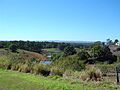
View east, towards Redland and Moreton Bay, from Mount Cotton, 2014
-
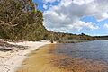
Shoreline of Brown Lake on North Stradbroke Island
-
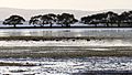
Cassim Island, viewed from G.J. Walter Park in Cleveland
-
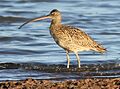
Eastern curlew visiting the shore of Cleveland

.JPG)


See also
 In Spanish: Redland City para niños
