
Eprapah facts for kids
Quick facts for kids Eprapah (environmental area)Victoria Point, Queensland |
|
|---|---|

Eprapah (environmental area)
Location in Queensland
|
|
| Established | 1928 |
| Postcode(s) | 4165 |
| Elevation | 10 m (33 ft) |
| Area | 0.39 km2 (0.2 sq mi) |
| Time zone | AEST (UTC+10) |
| LGA(s) | Redland City |
| Region | South East Queensland |
| State electorate(s) | Redlands |
| Federal Division(s) | Bowman |
| Website | Eprapah (environmental area) |
Eprapah, the Charles S. Snow Scout Environment Training Centre is a special nature area. It is located at Victoria Point, near Brisbane, Queensland, Australia. This important place is owned and looked after by the Scout Association of Australia. It covers 39 hectares (96 acres) and has many different natural areas along Eprapah Creek.
Local city leaders recognize Eprapah as an environmental reserve. It is also a special "Scout Centre of Excellence for Nature and Environment" (SCENES) site. This means it is one of the best places for Scouts to learn about nature. It might even be the only Scout camp in the world mainly focused on teaching about the environment!
The area is named after Eprapah Creek, which flows through it. The name Eprapah might come from the word Ephratah, meaning 'fruitful land'.
Contents
Why Eprapah is Special for Nature

Eprapah is one of several important nature spots in Redland City. Other areas include Venman Bushland National Park and the Kindilan Outdoor Education Centre, run by Girl Guides.
Eprapah is home to koalas and many types of natural environments. These include areas along the creek (riparian), where the creek meets the sea (estuarine), and even small rainforest patches. Eprapah Creek forms a natural path for animals from Mount Cotton. Scientists believe the area has about 120 plant species, 125 bird species, 24 types of mammals, 50 kinds of fish, 21 reptiles, and at least 60 insect species.
Scientists have studied Eprapah and its creek. They have looked at water flow and tracked koalas to learn more about them.
Nearby Nature Areas
As more homes are built, Eprapah helps protect the creek and its important wildlife. Near the coast, the Victoria Point Environmental Precinct stretches to the Moreton Bay Marine Park.
To the east, you can find the egret colony wetlands. These lowlands are surrounded by paperbark tea-trees and are home to many birds. You can see egrets, magpie geese, osprey, whistling kites, and different types of ibis. A bat colony also roosts here. This area is looked after by the Redland City Council and local volunteers.
To the north-east is the Point Halloran Conservation Area. It has walking paths and was once called a 'koala ecotourism sanctuary'. A raised boardwalk takes you through freshwater plants. Another walk shows different types of trees, like swamp she-oak (Casuarina sp.) and mixed woodland, leading to mangrove mudflats. You can see large termite mounds here, showing the wet soil.
There are also bushland areas upstream of Eprapah. One is on Elysian Street in Victoria Point. Further upstream is the Sandy Creek Conservation Area near Mount Cotton.
Eprapah's Land and Water

Eprapah is mostly flat as it reaches the coast. The creek starts near Mount Cotton, which is a 233-meter (764 ft) tall granite hill. The soil here is mostly clay and sand, typical for a creek flowing into a bay.
Eprapah Creek's estuarine zone (where fresh and salt water mix) is wet and tropical. It gets a lot of freshwater when it rains but little when it's dry. A sewage treatment plant also releases water into the creek.
When the Victoria Point Shopping Centre was built, it increased water runoff. Rain now turns the calm creek into a fast-flowing stream, bringing more trash with it.
Because Eprapah has so many different natural areas in a small space, it is very important for the environment. This is especially true as more buildings are built around it.
Plants at Eprapah
Eprapah has many types of plants. You can find low sclerophyll forest on sandy ridges. There are also small rainforest areas, sheoak (Casuarina sp.) forests, Melaleuca swamps, salt meadows, and mangrove trees.
One important tree for koalas, Queensland's animal symbol, is the blue gum (Eucalyptus tereticornis). You can also see scribbly gum (Eucalyptus signata).
The beautiful golden-flowering Eprapah wattle (Acacia fimbriata var perangusta) grows here. It is a special type of the Brisbane golden wattle.
Some parts of Eprapah have had new plants added after weeds were removed. The site has worked hard to get rid of harmful non-native plants like Lantana camara and groundsel (Baccharis halimifolia). They also deal with mosquitoes and ticks. The team removes plants like Camphor laurel trees and Asparagus fern that don't belong. Birds often spread seeds from nearby ornamental plants. Sometimes, people also dump trash illegally on the property.
Animals at Eprapah

Eprapah is part of a wildlife corridor that connects Mount Cotton to Eprapah Creek. This helps animals move freely and increases the variety of life (biodiversity) in the Redlands. This corridor was set up in 1990 by the Scouts and the local council.
Eprapah is home to koalas (Phascolarctos cinereus), bandicoots (Isodon macrourus), black-tailed swamp wallabies (Wallabia bicolor), grey kangaroos (Macropus giganteus), kookaburras, and even a sea eagle. You can also see large termite mounds.
Koalas in eastern Australia are now considered vulnerable, meaning their numbers are dropping. Their population has fallen by 40% in Queensland over the last 20 years. This is due to more buildings (urbanisation), roads, and dogs, which break up their homes. Overcrowding at Eprapah has also led to fewer koalas because they run out of food trees. They can also get diseases like chlamydia.
Scientists have studied koalas here by catching them, checking their health, and putting radio collars on them.
The freshwater area is also home to the near-threatened tusked frog (Adelotus brevis). This is the only Australian frog where the male is bigger than the female. They make a special 'tok-tok' sound. Their numbers are decreasing because their homes are being taken over, new fish are introduced, and a deadly skin disease is spreading.
The platypus (Ornithorhynchus anatinus) used to live in the creek pond near Cleveland-Redland Bay Road. But the water has become cloudy and less clean, so platypuses have not been seen there for many years.
Eprapah is also important for migratory birds. It is part of the East Asian–Australasian Flyway and the Moreton Bay Ramsar wetlands. An egret colony wetlands is just 1000 meters (1093 yd) east of Eprapah.
The pond, filled by rain, has many water creatures. These include Gambusia fish, whirligig beetles, backswimmers, dragonfly nymphs, and mayfly nymphs. The tidal part of Eprapah Creek has fish, molluscs, and crabs.
Eprapah's Indigenous History
Eprapah was once home to the Koobenpul tribe, part of the Jagera/Yagera language group. Their land stretched from Redland Bay to the Brisbane River.
Victoria Point's Aboriginal name, Warra Warra, might mean mussels. Coochiemudlo refers to the red rock of the small island.
A shell midden (an old pile of shells from Aboriginal meals) was found at Eprapah, but its exact spot is now unknown.
Aboriginal people used many plants found at Eprapah. For example, the red ash (Alphitonia excelsa) was used as a poison. The lillypilly (Syzygium smithii) had edible, crunchy fruit. Black bean (Castanospermum australe) was a food source after special treatment. Paper bark (Melaleuca sp.) was used for carrying containers. A garden of native food plants has been started near the Mungara visitor centre.
European History at Eprapah
Before Queensland became its own colony in 1859, the Eprapah area was used for cattle. Victoria Point was named in the 1840s. 'Eprapah Creek' became a post office name in 1890. The Colburn family, whose name is on a road today, settled here in the 1860s.
Most people in the area were farmers. They also cut timber. Link Road nearby was used to float logs to mills in Cleveland and Wellington Point. Farmers grew sugar, custard apples, grapes, passion fruit, pawpaws, pineapples, tomatoes, cabbages, and cucumbers. Pineapples from here were sent to Sydney and Melbourne.
In 1898, local governments debated building a 600-foot (183 m) road bridge over Eprapah Creek. The bridge was improved in 1924.
Eprapah was used as a district name until about 1915. In the 1930s, Victoria Point was a popular holiday spot, with trips to Coochiemudlo Island. After World War II, farming and tourism continued. In the 1970s, crop farming changed to flower growing. Through all this time, Eprapah remained a natural bushland area.
Eprapah's Scouting History
| Eprapah Scout environment training centre | |||
|---|---|---|---|
| Country | Australia | ||
|
|
|||

In April 1928, the Eprapah property was bought using money from the Bob Monteith Memorial Fund. Robert Henry Monteith was a soldier who died in France in 1918. His parents, who were involved in Scouting, set up the fund to remember their son.
The 39-hectare site is also home to the Victoria Point Scout Group, formed in 1969. This group uses a hut that was a hospital during World War II.
Eprapah has a sleeping shelter (bunkhouse), the Grey Owl activity shelter (built 1974), and the Biolab study shelter (1976). The Mungara visitor museum (1993) is a restored old cottage. It is now a meeting room, education center, and museum. Mungara means Queensland Blue Gum tree in the local Aboriginal language. Sadly, the Grey Owl shelter was destroyed by fire in 2019.
The old Westpac Bank building from the 1982 Australian Scout Jamboree became the site's caretaker's cottage. It was taken down in 2015 because it was in bad shape.
Eprapah's main purpose today fits with the Scout Promise and Law:
- A Scout is a friend to animals.
- A Scout cares for natural resources.
- A Scout cares for the environment.
The Australian Scout Environment Charter explains how Scouts can help the environment. This includes learning through nature, learning about nature, and taking action for nature.
Robert Baden-Powell, the founder of Scouting, wrote a lot about how important nature and environmental education are:
- "For those who have eyes to see and ears to hear, the forest is at once a laboratory, a club and a temple."
- "As a Scout, you are the guardian of the woods. A Scout never damages a tree... For every tree felled, two should be planted."
- "By continually watching animals in their natural state one gets to like them too well to shoot them."
Early Years: 1928 to 1953

Eprapah was the main place for Scout leader training in Queensland, though young Scouts could also camp there. The first training course was on June 4, 1928. Leaders got their food from an area now called the Beaver Shelter. Young Scouts learned emergency responses, built bridges, and went rafting.
Baden-Powell visited Queensland several times. On March 26, 1931, his shoe print was put into concrete at Eprapah. A copy is there now, and the original is at the Scout Museum in Samford.
The State's governor, Sir Leslie Orme Wilson, also visited as the Chief Scout of Queensland in the 1930s.
The first of the site's two totem poles was carved in November 1931. It had an owl and Baden-Powell's boot print at its base. The chapel area was fenced to keep cattle out.
Scouts worked hard to improve the training ground. In 1933, they built a special gate at the entrance with a carved crocodile. An old scout hall was moved to Eprapah from Redland Bay in 1934.

In 1937, an eagle totem pole was added to the campfire circle. Rover Scouts spent two years carving a life-sized eagle from local wood. The eagle was painted bronze and stood 6 feet 4 inches (1.93 m) wide and 4 feet 9 inches (1.45 m) tall on top of a 19-foot (5.8 m) totem pole.
Many important Scouting leaders have structures or places named after them at Eprapah:
- Charles Smethurt 'Chief' Snow (1882–1953): He was a watchmaker and one of the first scoutmasters in Brisbane. He became the first chief scoutmaster for Queensland and helped buy Eprapah.
- Kenneth Alexander 'Kauri' Boyd (1905–1976): An optometrist who became an assistant international commissioner.
- Thomas 'Grey Owl' Gloster (1855–1941): A soldier and important person from Cleveland.
- John Victor 'Running Stag' Marquis-Kyle (1897–1981): He carved poles for the Providore (food store) and the owl totem pole.
- Louis Varsey 'Beaver' Masters (1885–1964): A Scout district on the Sunshine Coast is named after him.
- James Alfred 'Nebo' Manderson (1901–1964): A signwriter and Wolf Cub leader known for his stories.
- David Thain 'Kiwi' Weir (1889–1973): He was a field commissioner and leader trainer. Scouts from Nambour to Bundaberg compete for the Kiwi Woggle each Easter.
Changes: 1954 to 1972
In late 1953, the Queensland Boy Scouts' Association bought a new camping property called Baden-Powell Park in Samford. Leader training moved there, and items like the Eagle totem pole were transferred in 1955.
During this time, a large fire swept through Eprapah, damaging many trees and buildings. Part of the property was also used for widening Cleveland-Redland Bay Road.
Modern Era: 1973 to Today

In 1973, the Scouts started using Eprapah again for conservation studies. In 1975, the Redland Shire Council changed Eprapah's zoning for special purposes.
The center is named after Charles Smethurst Snow, who was the first chief commissioner of Scouts in Queensland. He was a big supporter of buying the property and protecting nature.
Many groups help look after Eprapah today:
- Branch Commissioners: Leaders in charge of Scouting programs across Queensland, especially for the environment. Dr. Bernard Stone was the first Branch Commissioner for Conservation.
- Friends of Eprapah: A group of supporters.
- Eprapah Scout Fellowship: Another group of dedicated volunteers.
- State Site Committee: The committee that manages the site.
You can still see the outline of a wooden suspension bridge built by the Manatunga Rover Crew and the Australian Army Reserve. It opened in 1978.
Eprapah was named a Scout Centre of Excellence for Nature and Environment (SCENES) before 1985. For a long time, it was one of only 13 such sites in the world and the only one in the Southern Hemisphere.
In 1985, the Scout Association hosted a week-long Asia/Pacific Environmental Conservation Seminar. Many Scouting and Guiding delegates from different countries attended. Experts from CSIRO, Queensland National Parks, Griffith University, and the Queensland Herbarium gave talks.
The Mungara building had an extension added in 2001. A historic silver plate, remembering Jimmy Tabau, Darnley Island's first Australian Native Scouter, was returned to Mungara. This plate survived bushfires in the 1960s.
From 2011 to 2012, a 1.8-meter (5.9 ft) high fence was built around the property. This "fauna exclusion fence" helps keep wildlife safe by preventing them from leaving the property and going onto busy roads.
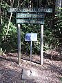
A heritage walk opened in 2014, with signs explaining Eprapah's Scouting history.
The Scout's State Environment Education Team often runs programs for Scouts and Guides. These programs are based on the World Scout Environment Programme and other merit badges. Activities include studying ecosystems, pond dipping, removing weeds, planting trees, and looking for animals at night.
Eprapah has various walking tracks and boardwalks for visitors:
- Koala Glade: Covers areas from the creek bank to open forest.
- Brown Trail: Goes around the chapel area.
- Green Trail: Follows Eprapah Creek.
- Blue Trail: A raised boardwalk through mangroves and salt marsh habitats.
Some trails have numbered posts with information from a visitor booklet. Near Colburn Avenue and Cleveland-Redland Bay Road, there are two special activity areas:
- A senses trail with plants of different textures.
- A native plants arboretum with wild foods, medicinal plants, and endangered plants (started in 2001).
Today, Eprapah has a Scout camping area and a shelter with bunks for over 15 people. Other groups, like artists, also use the facilities.
Members of the Scout Fellowship and other volunteers help maintain the environmental reserve. People from the community can join the fellowship or the site committee.
Gallery
-
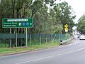
Looking south from the north-east corner, showing traffic density and dangers to wildlife
-
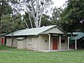
Mungara visitor centre, the original caretaker's cottage
-
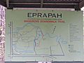
Eprapah site map
-
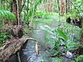
Freshwater pond, with Cleveland-Redland Bay Road in background
-
Koala Glade stream
-
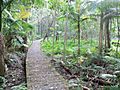
Koala Glade trail
-
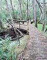
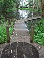
Boardwalk along the edge of the Eprapah Creek in the mangrove tidal zone
-
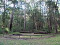
Eagle Campfire Circle
-
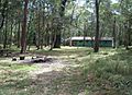
Kiwi camp ground and bunkhouse
-
Reproduction of Baden-Powell's shoeprint from March 1931
-
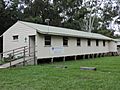
Victoria Point Scout Den


