Lamb Island, Queensland facts for kids
Quick facts for kids Lamb IslandRedland City, Queensland |
|||||||||||||||
|---|---|---|---|---|---|---|---|---|---|---|---|---|---|---|---|

Lamb Island
|
|||||||||||||||
| Population | 504 (2021 census) | ||||||||||||||
| • Density | 157.5/km2 (408/sq mi) | ||||||||||||||
| Postcode(s) | 4184 | ||||||||||||||
| Area | 3.2 km2 (1.2 sq mi) | ||||||||||||||
| Time zone | AEST (UTC+10:00) | ||||||||||||||
| LGA(s) | Redland City | ||||||||||||||
| State electorate(s) | Redlands | ||||||||||||||
| Federal Division(s) | Bowman | ||||||||||||||
|
|||||||||||||||
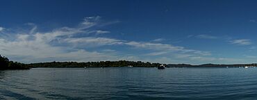
Lamb Island is a small island in Queensland, Australia. It is also a town and a local area within Redland City. In 2021, about 504 people lived on Lamb Island.
Contents
Island Location and Nature
Lamb Island is found in the southern part of Moreton Bay. It sits between the Queensland mainland and North Stradbroke Island. The island is part of the Moreton Bay Marine Park. This park helps protect the ocean and its creatures.
The island's land goes from sea level up to 26 meters high. Most of the land is used for homes. Near the south-east side of the island, there's a special protection zone. This area is a safe home for marine animals. You might find dugongs, dolphins, and leatherback turtles here.
Island History
Lamb Island has a long history of growing food. This started in the early 1900s. The island had many small farms. These farms sent their fresh produce to the Brisbane market. The island has a special climate and rich soil. This meant farmers could grow crops earlier than others.
Boats like the "Roo" and "Amazon" carried the produce. They traveled from the Brisbane River to the island. The "Roo" also brought supplies for island residents. Weekend visitors came to the island too. A popular spot was Peggy Saunders' garden parties. Peggy was a farmer's wife. Her beautiful garden was on the western side of the island.
In the late 1970s, Lamb Island changed. Many large farms were divided into smaller lots for homes. Only a few small farms remained. Most of these new small lots are still empty land. It can be costly to build homes here. This is because bringing building materials to the island costs money.
Recently, people have become interested in organic food again. Lamb Island is now known for its special climate. It's great for growing organic produce. There are also community gardens. Here, people grow organic food and pretty plants. Local artists also create things, often following Permaculture ideas.
The island has a very active group called LIRA. This stands for the Lamb Island Resident's Association. They work on projects to improve the community. This includes planting native trees. They also help fix and look after old historical sites.
Island Population
In 2011, Lamb Island had 427 people living there. About half were female and half were male. The average age was 51 years old. Most people (69.4%) were born in Australia. Others came from England, New Zealand, and the Philippines. Most people (90.4%) spoke only English at home.
By 2016, the population grew slightly to 432 people. The average age was 59 years. There were 330 private homes on the island. In 2021, the population reached 504 people.
Important Heritage Sites
Lamb Island has several places that are important to its history. These are called heritage-listed sites.
- Lavender Street: A dam and a forest of melaleuca trees.
- 109-123 Lucas Drive: The Lamb Island Pioneer Hall.
- Road Reserve at end of Lucas Drive: A Jetty Shed. Local islanders fixed this shed. It was used to load farm produce onto boats.
- At the end of Lucas Drive: Thomas Lucas’ Grave.
- Tina Avenue: Mango trees that are over 100 years old. They were planted by a group that brought new plants to the area.
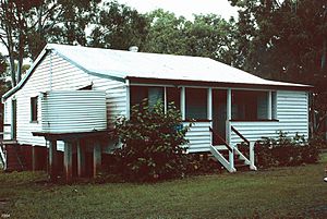
- A home on Tina Avenue: This was one of the first farmhouses. Later, it became the local post office and telephone exchange.
Schools and Learning
There are no schools directly on Lamb Island. The closest primary school is Macleay Island State School. This is on Macleay Island, a nearby island. For high school, students go to Victoria Point State High School. This school is on the mainland in Victoria Point.
Getting Around Lamb Island
You can get to Lamb Island by ferry or barge. Fast passenger ferries run often, usually every half hour. They run from about 4 am to midnight, seven days a week. Many people use these ferries to travel to the mainland for work.
The Lamb Island ferry terminal is at the southern end of Lucas Drive. This is the main road on the island. The fast ferry ride from the mainland takes about 15 minutes. 27°37′51″S 153°22′21″E / 27.63083°S 153.37245°E
A vehicle barge carries cars and large trucks. This barge takes about 45 minutes from the mainland. Traveling between the Southern Moreton Bay Islands on the fast ferry is free. The ferry service uses the Queensland Government's Translink go card system.
In late 2019, a local mini-bus service started on the island. It helps people get to and from the ferry terminal. Also in 2019, driverless bus trials happened on nearby Karragarra Island. The goal is to bring this service to the islands.
Island Services
Lamb Island has many helpful services for its residents:
- Electricity: Power comes from the mainland.
- Water: Water supply also comes from the mainland.
- Sewer: New homes must have modern water treatment systems.
- Internet/Telephone: Good internet is available. NBN, a fast internet service, became available in early 2020.
- Groceries: The island has a small convenience store. It is open every day. You can also order groceries online from Woolworths. They deliver to the island weekly.
- Alcohol: There is a bottle shop at the Lamb Island Recreation Club.
- Entertainment: The Lamb Island Recreation Club has a casual dining area. It also hosts live music and comedy shows.
- Sport: There is a public tennis and basketball court. It is next to Pioneer Hall and the Recreation Club.
Residents can also use an online car share service. These cars are on the mainland at the ferry terminal. You can book them using a mobile phone app.
Arts and Culture
Lamb Island has inspired some creative works. In 2010, a short film by Tim Marshall was named "Lamb Island." Peter Ludlow's book "Moreton Bay People" also talks about the island's history and people.
The island is part of Redland City Council's heritage trail. This trail points out important historical places. You can also find art around the island. One example is "Island Girl" by artist Antone Bruinsma. It is near the ferry terminal.
The "Girt by Sea" visual arts competition happens every year. It offers a large prize pool. The Redland City Council supports this event. They have bought several artworks from the competition. Some of these artworks are now displayed on Lamb Island.
 | Aaron Henry |
 | T. R. M. Howard |
 | Jesse Jackson |


