
Moreton Island, Queensland facts for kids
Quick facts for kids Moreton IslandBrisbane, Queensland |
|||||||||||||||
|---|---|---|---|---|---|---|---|---|---|---|---|---|---|---|---|

Moreton Island, 2016
|
|||||||||||||||

Moreton Island
Location in Queensland
|
|||||||||||||||
| Population | 180 (2021 census) | ||||||||||||||
| • Density | 1.031/km2 (2.67/sq mi) | ||||||||||||||
| Postcode(s) | 4025 | ||||||||||||||
| Area | 174.6 km2 (67.4 sq mi) | ||||||||||||||
| Time zone | AEST (UTC+10:00) | ||||||||||||||
| LGA(s) | City of Brisbane (Deagon Ward) | ||||||||||||||
| State electorate(s) | Redcliffe | ||||||||||||||
| Federal Division(s) | Bonner | ||||||||||||||
|
|||||||||||||||
Moreton Island is a beautiful island located in Queensland, Australia. It is also the name of the main area, or locality, on the island. Moreton Island is part of the City of Brisbane. In 2021, about 180 people lived here.
Contents
Island Geography
Moreton Island is mostly covered by the Moreton Island National Park. This means much of the island is protected nature. There are three smaller areas on the island that are separate from the main Moreton Island locality: Bulwer on the northwest coast, Cowan Cowan on the west coast, and Kooringal on the southwest coast. The famous Tangalooma Resort is also on the island.
Important Landmarks
The Cape Moreton Lighthouse stands on Cape Moreton, which is the most northeastern point of the island. It's a very important landmark.
The island has many interesting natural features, including:
- Mount Tempest: This is the highest point on the island, reaching 280 meters (about 918 feet) high.
- The Desert: A unique area with large sand dunes, perfect for sand tobogganing!
- Tangalooma: A popular resort area, also known as Turrbin.
Island History
.jpg)
Moreton Island and Moreton Bay were named by early explorers. In 1770, Captain James Cook named Moreton Bay after James Douglas, the Earl of Morton. He was a very important person who helped Cook get funding for his journey. Later, in 1799, Lieutenant Matthew Flinders named the island after the bay. The name "Morton" was accidentally misspelled as "Moreton" in the records, and it stuck!
Cape Moreton Lighthouse
As more ships came into Moreton Bay in the 1840s, a lighthouse was needed to guide them safely. The New South Wales Government built the Cape Moreton Lighthouse between 1854 and 1857. It was designed by an architect named Edmund Blacket. This lighthouse is special because it's the oldest one in Queensland. It's also the only lighthouse in Queensland made from stone. It still works today, helping ships navigate the waters.
Early Schools
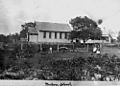
In the past, there were a couple of small schools on the island for the children of the lighthouse keepers and other residents.
- Moreton Island State School opened around 1876 and was later called Bulwer State School. It closed in 1909.
- Cape Moreton Provisional School opened in 1876 but closed and reopened a few times before closing permanently in 1925.
Island Population
The number of people living on Moreton Island changes over time.
- In 2016, there were 243 people living on the island.
- In 2021, the population was 180 people.
Education on the Island
There are no regular schools on Moreton Island today. Children who live there usually learn through distance education, where they study from home with lessons sent to them. Some children might also go to boarding schools on the mainland.
Getting Around Moreton Island
Moreton Island is an island, so there are no bridges to drive or take a train across. You can only get to the island by boat, like ferries or barges, or by air. Once you are on the island, only vehicles with 4WD are suitable for driving on the sandy tracks.
There are also several places for air transport:
- Tangalooma Airstrip
- Kooringal Airstrip
- Bulwer heliport
- Kooringal Emergency Centre heliport
- Cowan Cowan heliport
- Tangalooma Resort heliport
Images for kids
-
A cricket match at Bulwer State School in 1899.
-
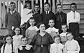
Students with their teacher at Cape Moreton State School, around 1913.


