
Logan River facts for kids
Quick facts for kids Logan |
|
|---|---|

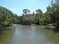
The Logan River at Jimboomba, 2011
|
|

Location of the Logan River mouth in Queensland
|
|
| Native name | Dugulumba |
| Country | Australia |
| State | Queensland |
| Region | South East Queensland |
| Local government areas | Scenic Rim Region, City of Logan, City of Gold Coast |
| Cities | Beaudesert, Logan City |
| Physical characteristics | |
| Main source | Scenic Rim below Mount Ernest 380 m (1,250 ft) 28°19′40″S 152°42′55″E / 28.32778°S 152.71528°E |
| River mouth | Moreton Bay east of Alberton 0 m (0 ft) 27°41′40″S 153°20′43″E / 27.69444°S 153.34528°E |
| Length | 184 km (114 mi) |
| Basin features | |
| Basin size | 3,076 km2 (1,188 sq mi) |
| Tributaries |
|
| National park | Mount Barney National Park |
The Logan River is a long river in Queensland, Australia. Its traditional name in the Yugambeh language is Dugulumba. The river is about 184-kilometre (114 mi) long. It flows through the Scenic Rim Region, Logan City, and City of Gold Coast areas.
The Logan River is very important for South East Queensland. It collects water from the southern mountains of the Scenic Rim. Then it flows into Moreton Bay. Near its end, you can find mangrove forests. There are also many farms that raise fish and shellfish, called aquaculture farms.
| Top - 0-9 A B C D E F G H I J K L M N O P Q R S T U V W X Y Z |
Journey of the Logan River


The Logan River starts high up in the mountains. It begins below Mount Ernest in the Scenic Rim. This area is part of the Great Dividing Range. The river forms inside the Mount Barney National Park. This is close to the border between Queensland and New South Wales.
The river flows mostly north and northeast. Many smaller streams, called tributaries, join it along the way. In total, eleven smaller waterways add to the Logan River. After that, it turns east and finally flows into Moreton Bay.
The Albert River is one of its main tributaries. It joins the Logan River near Beenleigh. Another important tributary is Teviot Brook. It starts at Mount Superbus. Burnett Creek is also a tributary. Its water is held back by the Maroon Dam. The river drops 380 metres (1,250 ft) from its source to its mouth.

_and_Alberton_(right),_2014.JPG)
The Logan River and its tributaries collect water from a huge area. This area is more than 3,000 square kilometres (1,200 sq mi). It includes parts of the Border Ranges National Park and the McPherson Range. The river's upper parts are near several national parks. These include Tamborine National Park and Lamington National Park. These parks are part of the UNESCO World Heritage Site called Gondwana Rainforests of Australia.
Many bridges cross the Logan River. The Mount Lindesay Highway crosses it in two places. The Pacific Motorway also crosses it. A railway line for the Beenleigh railway line also goes over the river. The ocean's tides can reach as far as Maclean's Bridge.
Water for the Community
The Maroon Dam is built on Burnett Creek. It helps supply water to the Beaudesert area. This dam is managed by a company called SunWater. The Queensland Government has looked into ways to supply more water. They are building a storage facility called Bromelton on the Logan River. The Cedar Grove Weir is also being built near Jimboomba.
In 2006, the government decided not to build a dam at Tilley's Bridge. This was because many people did not want it. It would also have been very expensive to move roads. Instead, they suggested building the Wyaralong Dam on Teviot Brook. This new dam would affect fewer properties.
History of the Logan River
The Yugambeh are the traditional owners of the land around the Logan River. They are part of the Jagera people. They used the river's natural resources for food. They called the river Dugulumba. The Yugambeh language was spoken in many areas. These include Beenleigh, Beaudesert, and the Gold Coast.
In August 1826, Captain Patrick Logan was the first European to find the river. He first named it the Darling River. But to avoid confusion, the Governor changed the name. He named it the Logan River to honor Captain Logan.
By the 1860s, boats were very busy on the river. This was because it was the best way to travel. Steamships and small boats were common. In 1871, the river was mapped for navigation. Wharfs were built at places like McLean and Beenleigh. People started unofficial ferry crossings as early as 1862. Later, official ferry services were set up. A railway bridge was built in 1885. It was destroyed by floods two years later. A new bridge opened in 1888 and lasted until 1972.
In 1905, a dead crocodile was found by the river. People had reported seeing crocodiles for years. But many did not believe them. This was because southern Queensland is usually too far south for crocodiles.
A toll bridge opened north of Beenleigh in 1931. People had to pay to cross it. This was because more cars were traveling between Brisbane and the Gold Coast on weekends. The worst flood in the river's lower parts happened in 1974.
Water Quality and Conservation
The water in the Logan River is often very cloudy. A report in 2007 said the river's health was very poor. This is because of things like clearing land and pollution. Wastewater from treatment plants also flows into the river. In 2009, the river's health was rated very low.
Local community groups are working to make the river healthier. They hold competitions to reduce the number of carp fish. Carp are not native to the river. Reducing them helps native fish species survive better.
Images for kids
-
The Logan River at Jimboomba, 2011
