
Albert River (South East Queensland) facts for kids
Quick facts for kids Albert |
|
|---|---|

Albert River at Stapylton, 2014
|
|

Location of Albert River river mouth in Queensland
|
|
| Country | Australia |
| State | Queensland |
| Region | South East Queensland |
| Local government areas | Scenic Rim Region, City of Gold Coast |
| Physical characteristics | |
| Main source | McPherson Range, Great Dividing Range |
| River mouth | confluence with the Logan River Alberton 3 m (9.8 ft) 27°41′42″S 153°14′30″E / 27.69500°S 153.24167°E |
| Length | 102 km (63 mi) |
| Basin features | |
| River system | Logan River |
| Basin size | 782 km2 (302 sq mi) |
The Albert River is a river in the South East region of Queensland, Australia. It flows all year round. The area where its water collects, called its catchment, is about 782 square kilometers. This area includes parts of the City of Gold Coast and Scenic Rim Region. The river helps provide drinking water for the town of Beaudesert.
Contents
Journey of the Albert River
The Albert River starts when two smaller streams, the Right and Left Branches, join together. These streams begin in the Lamington National Park. They flow down from the northern parts of the Border Ranges, which are part of the Great Dividing Range. The river starts below a place called Neglected Mountain, near the town of Hillview.
River Flow and Tributaries
The Albert River generally flows north. Along its journey, six smaller streams, called tributaries, flow into it. These tributaries include Stockyard Creek, Duck Creek, Kerry Creek, Cainbable Creek, Canungra Creek, and Bidaddaba Creek. Eventually, the Albert River joins with the Logan River between Alberton and Eagleby. From there, the Logan River flows another 12 kilometers before reaching Moreton Bay.
Surrounding Areas and Parks
The Albert River's catchment area is surrounded by mountains. The McPherson Range is to the south, the Beechmont Range is to the east, and the Jinbroken Range and Birnam Range are to the west. The upper part of the river's catchment is very important for nature. It includes Tamborine National Park, Main Range National Park, and the Lamington Plateau. Many local government reserves and conservation areas are also found here. These parks are part of the UNESCO World Heritage Site called the Gondwana Rainforests of Australia.
River Crossings
Several important roads and a railway line cross the Albert River. These include the Pacific Motorway, the Old Pacific Highway, and the Gold Coast railway line. They all cross the river at Yatala.
History of the Albert River
The Albert River was named by Robert Dixon. He named it in honor of Prince Albert of Saxe-Coburg and Gotha.
First Peoples of the Land
The land around the Albert River has been home to Aboriginal people for thousands of years. The Yugembah people are one of the Aboriginal groups connected to this area. Their language, Yugembah, was spoken in places like the Gold Coast, Logan, and the Scenic Rim. Another group, the Mununjali people, speak a dialect of the Yugambeh language. Their traditional lands include parts of the Scenic Rim and Beaudesert Shire.
Past Events on the River
The Albert River has experienced floods many times throughout history. Big floods were recorded in 1925, 1947, 1972, 1976, 1980, 1989, and 2017. The 2017 flood was caused by Cyclone Debbie. In 1884, a ship called the S.S. Walrus got stuck on the riverbank. This ship was used to process sugar and make alcohol.
Plans for a Dam
In the past, there were ideas to build a dam on the Albert River. One proposal in 1989 for a dam called Wolffdene Dam was not approved by the government. Later, in 1990, another dam was planned near Glendower Homestead. However, this idea was also dropped because it would have been too expensive to build for the amount of water it would provide.
Caring for the Albert River
The water quality in the Albert River is generally good until it meets the Logan River. After that, the water quality tends to get worse. This is mainly due to human activities.
Environmental Challenges
- Development: More homes and businesses are being built along the river. This can affect the river's health.
- Land Clearing: Removing trees and plants from the land can lead to soil washing into the river.
- Water Flow Changes: Human activities can change how the water flows, which can cause the riverbanks to wear away.
- Pollution: Waste and pollution from homes and industries can harm the water quality, especially in the lower parts of the river.
- Invasive Species: Non-native plants and animals can take over and harm the natural environment.
It is important for everyone living and working near the Albert River to help protect it. This includes managing waste properly and being mindful of how our actions affect the river's health.
Gallery
-
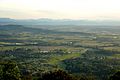
View west over Wonglepong and the Albert River, 2010
-
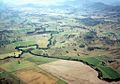
The Albert River valley and farmlands, south east of Beaudesert. Cainbable Creek flows into the Albert River from the east.


