Yatala, Queensland facts for kids
Quick facts for kids YatalaGold Coast City, Queensland |
|||||||||||||||
|---|---|---|---|---|---|---|---|---|---|---|---|---|---|---|---|

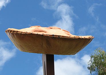
The Big Pie sign, 2008
|
|||||||||||||||
| Population | 1,405 (2021 census) | ||||||||||||||
| • Density | 100.4/km2 (260/sq mi) | ||||||||||||||
| Postcode(s) | 4207 | ||||||||||||||
| Area | 14.0 km2 (5.4 sq mi) | ||||||||||||||
| Time zone | AEST (UTC+10:00) | ||||||||||||||
| Location |
|
||||||||||||||
| LGA(s) | City of Gold Coast | ||||||||||||||
| State electorate(s) | Coomera | ||||||||||||||
| Federal Division(s) | Forde | ||||||||||||||
|
|||||||||||||||
Yatala is a suburb located in the City of Gold Coast, Queensland, Australia. It's a growing area with a mix of homes and businesses. In 2021, about 1,405 people lived here.
Contents
Where is Yatala?
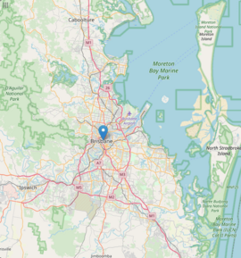
Yatala is surrounded by other suburbs like Beenleigh, Windaroo, and Stapylton. It is found near where the Albert River joins other waterways. This river is at the northern end of the suburb.
What Does the Name Yatala Mean?
The name Yatala comes from a property on the Albert River. This property was named by someone from South Australia. They named it after Yatala Harbor near Port Augusta, South Australia.
The word is thought to come from the Kaurna Aboriginal language. 'Yertalla' means 'water running by the side of a river'. It specifically described when dry plains in South Australia filled with water after heavy rain.
A Look Back: Yatala's History
Early Buildings and Schools
St Mary's Catholic Church opened on December 12, 1875. It was first built as a hall for a group called the Masons. This church building is no longer standing today.
St Joseph's School also opened in November 1875. However, it closed just two years later in December 1877.
From Safari Park to Industrial Hub
From 1969 to 1988, Yatala was home to an African safari park. This park was run by Bullen Circuses. It was sold because it wasn't making enough money.
The land where the safari park once stood is now used for businesses. You can find this area on what is now Lions Park Drive in Yatala.
The Famous Yatala Brewery
In 1988, a new brewery called Power's Brewery opened in Yatala. This brewery later joined with Carlton & United Breweries (CUB) in 1992. CUB then bought it completely in 1993.
The Yatala brewery became very important for CUB. By 2010, it had grown to more than 20 times its original size. It now produces a quarter of all the beer made in Australia.
Modern Growth and Development
Rivermount College, a school, opened its doors in Yatala in 1992.
Since 2006, Yatala has been growing very quickly. More than 300 businesses have now set up in the area. This growth is turning the rural land between Brisbane and the Gold Coast into urban areas. There is only about 6 kilometers of this land left between the two cities.
Who Lives in Yatala?
In 2021, Yatala had a population of 1,405 people. About 50.6% were female and 49.4% were male. The average age of people in Yatala was 43 years old. This is 5 years older than the average age for all of Australia.
Most people (76.7%) living in Yatala were born in Australia. Other countries of birth included New Zealand (5.1%) and England (4.5%). Most people (89.7%) spoke only English at home. Other languages spoken included Maori (New Zealand), Afrikaans, and Dutch.
What is Yatala Known For?
Local Businesses
The Yatala Brewery is a major business in the area. It is located near the Pacific Motorway.
Yatala is also home to Supercar racing teams. Matt Stone Racing is based here. In the past, Stone Brothers Racing and Erebus Motorsport were also located in Yatala.
Kanga Loaders, a company that makes heavy machinery, has its main office in Yatala.
Education Options
Rivermount College is a private school in Yatala. It teaches students from Preparatory (youngest) to Year 12. In 2018, the school had 917 students.
There are no government schools directly in Yatala. Students usually go to nearby government primary schools. These include Norfolk Village State School in Ormeau or Mount Warren Park State School in Mount Warren Park. For high school, students can attend Ormeau Woods State High School in Ormeau, Beenleigh State High School in Beenleigh, or Windaroo Valley State High School in Windaroo.
Parks and Recreation
While there isn't a public library in Yatala itself, the Gold Coast City Council has a mobile library. This library regularly visits the nearby suburb of Ormeau.
Yatala has many parks for people to enjoy:
- Beenleigh Special Needs Park
- Brewery Reserve
- Darlington Drive Park
- David Arbon Park
- Enkleman Road Park
- Ferguson Park
- Freeway Reserve Yatala
- Gassman Reserve
- Link Park
- Lower Halfway Creek Parklands
- Luscombe Reserve East
- Luscombe Reserve West
- Pagan Parklands
- Paterson Park
- Sears Road Reserve
- Stanmore Park
- Yatala Laneway Reserve
Getting Around Yatala
Yatala is connected to nearby train stations by bus. Bus routes 728 and 729 link Yatala to Beenleigh and Ormeau railway stations. These bus services are run by Kinetic Group.
Famous Yatala Pie Shop
Yatala is famous for the Yatala Pie Shop. This shop says it has been a well-known spot in the area for over 130 years. It is a popular stop for people traveling between Brisbane and the Gold Coast.
 | Kyle Baker |
 | Joseph Yoakum |
 | Laura Wheeler Waring |
 | Henry Ossawa Tanner |


