Luscombe, Queensland facts for kids
Quick facts for kids LuscombeGold Coast City, Queensland |
|||||||||||||||
|---|---|---|---|---|---|---|---|---|---|---|---|---|---|---|---|

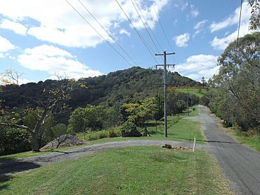
Needham Road, 2016
|
|||||||||||||||
| Population | 265 (2021 census) | ||||||||||||||
| • Density | 15.59/km2 (40.4/sq mi) | ||||||||||||||
| Postcode(s) | 4207 | ||||||||||||||
| Area | 17.0 km2 (6.6 sq mi) | ||||||||||||||
| Time zone | AEST (UTC+10:00) | ||||||||||||||
| Location |
|
||||||||||||||
| LGA(s) | City of Gold Coast | ||||||||||||||
| State electorate(s) | Coomera | ||||||||||||||
| Federal Division(s) | Forde | ||||||||||||||
|
|||||||||||||||
Luscombe is a quiet, countryside area located in the City of Gold Coast, Queensland, Australia. In 2021, about 265 people lived there.
Contents
Exploring Luscombe's Landscape
Luscombe is next to the Albert River on its eastern side. You'll find some big quarries (places where rocks are dug up) in the northern and eastern parts of the area. A main road called Beaudesert–Beenleigh Road also passes through the south-west part of Luscombe.
A Look Back at Luscombe's Past
Years ago, Luscombe was home to the Darlington Park Raceway. This was a 1.3-kilometer long track where people raced go-karts! It even appeared on a TV show called The Mole. However, the raceway closed down on February 3, 2007. This happened because people living nearby complained about too much noise. Today, an industrial estate (a place with many businesses) stands where the raceway used to be.
Education Opportunities Near Luscombe
There are no schools directly in Luscombe itself. However, students can attend nearby primary schools. These include Cedar Creek State School in Cedar Creek, Windaroo State School in Mount Warren Park, Ormeau State School in Pimpama, and Norfolk Village State School in Ormeau. For high school, students usually go to Windaroo Valley State High School in Bahrs Scrub or Ormeau Woods State High School in Ormeau.
Parks and Green Spaces in Luscombe
Luscombe has several lovely parks where people can relax and enjoy nature:
- Halls Road East Parklands (27°47′52″S 153°10′59″E / 27.7979°S 153.1830°E)
- Halls Road Reserve (27°47′06″S 153°11′21″E / 27.7850°S 153.1893°E)
- Halls Road South Reserve (27°47′37″S 153°10′59″E / 27.7935°S 153.1831°E)
- Luscombe Reserve East (27°45′55″S 153°12′39″E / 27.7653°S 153.2107°E)
 | Dorothy Vaughan |
 | Charles Henry Turner |
 | Hildrus Poindexter |
 | Henry Cecil McBay |


