
Fort Lytton facts for kids

Fort Lytton is an old fort from the 1800s. It is located in Lytton, a suburb in Brisbane, Queensland, Australia. This fort is now a heritage-listed site. The name 'Fort Lytton' also refers to the larger military area around the fort, which was about 1 square mile (2.6 square kilometers). Fort Lytton was built between 1880 and 1882. It was used until 1965. Today, the old fort is part of Fort Lytton National Park. The park is open to visitors on most Sundays and public holidays. Volunteers from the Fort Lytton Historical Association offer guided tours.
Contents
Why Fort Lytton Was Built
Fort Lytton was built from 1880 to 1882. It was created because people worried that countries like Russia or France might attack Brisbane or its port by sea. Both Brisbane and its port are located along the Brisbane River. The fort was designed by a military expert named Lieutenant-Colonel Peter Scratchley.
The fort was placed at the mouth of the Brisbane River. Its main job was to stop enemy ships from entering the river. At first, this was done with a minefield across the river mouth. This minefield was controlled from a distance. The fort also had four large guns. By 1888, two of these guns were replaced with newer, more powerful ones. Five years later, two quick-firing Hotchkiss guns were added. The minefield was closed in 1908, but the large guns were used until 1938.
Fort Lytton was also a very important training base. Thousands of soldiers trained here for the Boer War, World War I, and World War II. For its first 40 years, it was the main training spot for Queensland's reserve soldiers. Each year, up to 5,000 reserve soldiers trained at Fort Lytton.
Protecting Brisbane
The Australian colonies were part of the British Empire. By the 1800s, the British Empire had many enemies. Other countries were quickly expanding their own empires. When the fort was built, Brisbane had fewer than 100,000 people. Its yearly trade was worth more than four million pounds.
Brisbane was more open to sea attacks than Sydney or Melbourne. This was because it was only a three-day sail from the French naval base in Nouméa. Local defenses were very important. Moreton Bay had many islands where an enemy could set up a base.
Experts like Colonel Sir William Jervois and Scratchley suggested that Queensland should rely on Fort Lytton. It was a strong defense for Brisbane, which was the capital and wealthiest port.
The fort looks like a typical fortress from the 1800s. It is shaped like a pentagon and hidden behind grassy banks. A moat filled with water surrounds it for extra protection. The Parliament of Queensland approved building the fort in Lytton in 1878. A group of artillery, engineers, and infantry soldiers was also created. Their job was to defend against any land attacks. The government also developed a small marine defense force. This force included two gunboats and a torpedo boat.
Lytton Hill's Role
Lytton Hill was the only important hill in the Fort Lytton area. This made it very important for defense. It is about 0.75 miles (1.2 kilometers) east of the main fort. In the mid-1880s, a small fort called a redoubt was built on the hill. It was used as a lookout point. It also served as a base for soldiers who protected Fort Lytton from land attacks.
Lytton Hill was connected to Fort Lytton by telegraph. This allowed them to send messages quickly. Lytton Hill could watch and report ship movements in Moreton Bay. It also reported any enemy forces moving on land. During the Second World War, Lytton Hill had an army signals station and an air force radar station.
Lytton Hill was also used for other purposes. It helped with communications to the prison on St Helena Island. It temporarily housed a school for boys. It also had a radar station for the Brisbane Pilot Service.
Fort Lytton in Wars
Boer War (1899-1902)
The Second Boer War was fought in Southern Africa. Over 3,000 Queensland soldiers were sent to help the British forces. Most of these were mounted troops. Nine groups of soldiers sailed from Brisbane between 1899 and 1902. Most, if not all, of these groups gathered and trained at Fort Lytton before leaving.
First World War (1914-1918)
During the First World War, Fort Lytton was mainly a training place. Troops prepared here before going overseas. The fort also had its own wharf where many soldiers boarded ships. The fort's guns were used twice. They fired warning shots near two ships that were not following wartime rules. After the war, the fort was used to house returning soldiers. They stayed in tents as part of the nearby quarantine station.
Second World War (1939-1945)
Fort Lytton's role changed a lot during the Second World War. It became part of a much larger defense system. Between 1937 and 1943, four more forts were built to protect Moreton Bay. These new forts stopped enemy ships from reaching the Brisbane River. Fort Lytton then provided the inner defense.
The four outer forts were Fort Bribie and Fort Skirmish on Bribie Island. The others were Fort Cowan Cowan and Fort Rous on Moreton Island. Each of these forts had two six-inch guns. This gave them coverage over most of Moreton Bay. The navy also used special loops and minefields in the deep water channels. These could detect and destroy enemy ships, including submarines.
One of Fort Lytton's jobs was the "Inner Inspection Station." This meant it could send teams to board and check ships. This made sure it was safe for them to go up the river. A ship called HMAS Kinchela was always anchored near the middle of the river by Fort Lytton. Two strong steel nets blocked the river permanently on one side of Kinchela. Two movable steel net gates blocked the river between Kinchela and the fort. Large winches at Fort Lytton and on Kinchela opened and closed these gates. Searchlights lit up the net when needed. Systems across the river mouth warned of approaching ships. Guns at the fort protected the boom gate. These included a 4.7-inch naval gun and a twin 6-pounder rapid-fire gun. This gun was controlled from a 15-meter (49-foot) high lookout tower.
Many other defense activities were based at Fort Lytton. These included a signals station, a radar station, and a heavy anti-aircraft battery. Brisbane's defenses grew stronger during WW2. This was because Brisbane became very important to the war effort. By 1943, Brisbane was a major submarine base. A total of 89 submarines were repaired in Brisbane over three years.
Korean War (1950-1953)
Over 17,000 Australians served in the Korean War. Fort Lytton's signal station provided important communications. It connected Australia with its forces in Korea. The signal station was greatly improved at this time. This included better radio equipment, masts, and antennas.
After the Wars
Fort Lytton began to close down after the Second World War ended. However, the signal station kept working until late 1965. The fort's last important defense operation was in October 1965. The signals station was used to gather information about the "Indonesian coup." This event led to General Suharto becoming president.
Soon after this, the Fort Lytton site was given to the AMPOL oil company. They built an oil refinery there. Most of the site became oil refining and storage facilities. But three parts of the land were left untouched. These were the colonial fort and its buildings, Lytton Hill and its structures, and the heavy anti-aircraft battery area. This battery had four protected gun pits and a command post.
The oil company gave the colonial fort site to the Queensland Government in 1988. This area became Fort Lytton National Park in 1990. Lytton Hill and the heavy anti-aircraft battery are still inside the refinery today.
Gallery
-
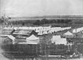
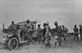
Eastern training encampment, 1881
-
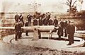
Submarine mining engineers with submarine mine c.1890
-
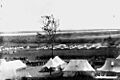
Encampment, c1895
-

Encampment of soldiers and horses, c1899 (possibly a Boer War contingent)
-
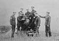
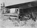
Armstrong 6-inch 100pdr Breech Loading Disappearing Gun in Firing Position, c1900
-
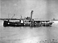
Submarine minefield service vessel "Miner" with spherical mines and connecting cables hanging over side
-
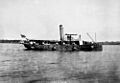
Submarine minefield service vessel "Miner" with cylindrical mines and connecting cables hanging over side.
-
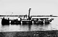
Submarine minefield service vessel "Miner" with conical mines and connecting cables hanging over side
-
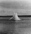
The last submarine mine being exploded at Fort Lytton on closure of the submarine minefield 1908
-
Lord Kitchener visiting Fort Lytton, 1910
-
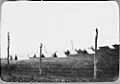
A tent quarantine camp at Fort Lytton in 1919
-
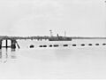
Anti-submarine boom (net) at Fort Lytton during the Second World War. Two moving boom gates were operated by winches located at the fort and on the permanently anchored ship.
-
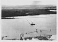
Anti-submarine boom gate in open position (foreground) and permanently anchored ship "HMAS Kinchela" (background). 1943.
-
4.7-inch gun protecting the anti-submarine boom at Fort Lytton, 1943
-
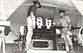
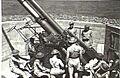
Gunners at 4.7-inch gun watching vessels at river mouth. 1943.
-

Twin-6pdr gun providing anti-motor-torpedo-boat defence at Fort Lytton 1943 (protected mount - foreground, command tower (background)
-
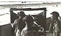
Officers inspect breeches of twin 6pdr gun. 1943.
-

'T' Australian Heavy Battery at Fort Lytton with M1917/1918 155-mm heavy gun. Heads are bowed during a ceremony on Armistice Day 1943
-
-
Gunners working on 3.7-inch heavy anti-aircraft gun. 1943.
-
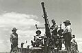
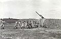
Gunners of 651st Light Anti-aircraft Battery, Volunteer Defence Corps training on Bofors gun at Fort Lytton 1944

.jpg)


.jpg)
.jpg)
.jpg)


