Bribie Island Second World War Fortifications facts for kids
Quick facts for kids Bribie Island Second World War Fortifications |
|
|---|---|

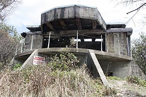
Southern gun emplacement from east, 2013
|
|
| Location | Woorim, Moreton Bay Region and Bribie Island North, Sunshine Coast Region, Queensland, Australia |
| Design period | 1939–1945 (World War II) |
| Built | 1939–1943 |
| Official name: Bribie Island Second World War Fortifications | |
| Type | state heritage (archaeological, built) |
| Designated | 20 July 1993 |
| Reference no. | 601143 |
| Significant period | 1939–1943 (fabric) 1939–1945 (historical) |
| Significant components | searchlight emplacement, engine/generator shed/room / power supply, pump house, observation post (military), command post, signal station/post, cable – communication, sewage farm/treatment site, mine control station (military), gun emplacement, slab/s – concrete |
| Lua error in Module:Location_map at line 420: attempt to index field 'wikibase' (a nil value). | |
The Bribie Island Second World War Fortifications are old military buildings on Bribie Island, Queensland, Australia. They are found near Woorim and at the northern end of the island. These forts were built between 1939 and 1943 during World War II. Today, they are protected as important historical sites on the Queensland Heritage Register.
Why Were Bribie Island Forts Built?
The Bribie Island Fortifications were built from 1939 to 1943. They were part of a big plan to defend southeast Queensland during World War II. These forts also helped train Australian soldiers for fighting overseas. Other forts were built around Moreton Bay, including at Caloundra and on Moreton Island. All these forts worked together to protect the area.
In the 1930s, as war seemed likely in Europe and Asia, Australia started to improve its defenses. Major cities and ports needed protection from naval attacks. So, new military batteries were set up in places like Sydney and Darwin. The main goal was to stop enemy ships from shelling ports or launching torpedoes.
Before the 1930s, the main defense for the Moreton Bay area was Fort Lytton near the Brisbane River. But by the mid-1930s, it was clear more modern defenses were needed.
The shipping routes in Moreton Bay made it easy to pick the best spots for these forts. The main way into the Brisbane River was a Z-shaped channel. This meant the best places for guns were near the bends in this channel.
On September 1, 1939, Germany invaded Poland. Two days later, Australia declared war on Germany. This made the need for strong defenses even more urgent.
Fort Bribie: Protecting Moreton Bay
Bribie Island was a popular holiday spot. People would arrive by steamer from Brisbane. A road led from the jetty to Woorim, a popular surfing beach. When the Australian Army started moving onto the island in 1939, some local residents had to move from their homes.
In 1939, temporary gun batteries were set up at Caloundra and northern Bribie Island. These were meant to help the Royal Australian Navy (RAN) against small enemy warships. There was also a battery at Cowan Cowan Point on Moreton Island.
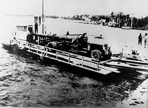
Two large six-inch guns, left over from World War I, were brought to the northern end of Bribie Island to create Fort Bribie (26°51′14″S 153°07′45″E / 26.8540°S 153.1292°E). At first, the gun mounts weren't strong enough. The guns would tilt a lot after firing!
In 1940, there was a lot of debate about whether Caloundra would be a better location for a main fort. But Bribie Island was chosen because it was in a better tactical spot. Fort Bribie was developed to be the main defense for Moreton Bay. It would be the "Examination Battery," where ships had to identify themselves.
Colonel John Whitelaw, a commander of coastal defenses, visited Fort Bribie in 1940–41. He suggested what buildings and structures were needed. His ideas were put into action in 1941, and the fort was ready by early 1942. The construction cost about £55,000. This included the fort buildings, offices, supply areas, and living quarters. The layout of Fort Bribie changed often as new buildings were added.
The fort had two six-inch gun emplacements. It also had a Battery Observation Post (BOP) about 200 yards north. This post helped command the battery and measure distances to targets. Colonel Whitelaw also suggested a Fortress Observation Post (FOP) at Caloundra to work with Fort Bribie's BOP. Many of the barracks and other buildings were made of timber or fibrous cement on concrete bases.
When Japan entered the war in December 1941, Australia faced a serious threat of invasion. More soldiers and supplies were sent to Fort Bribie and Fort Cowan Cowan to make them stronger.
The Pacific War brought many American soldiers and a lot of equipment. Australia received 155mm guns from World War I to improve its coastal defenses. New forts were built in 1942–43 at Skirmish Point on south Bribie Island and Rous on Moreton Island. The Skirmish Point Battery at Woorim had two fixed 155mm guns.
The Australian Women's Army Service (AWAS) arrived in 1943. They helped with most tasks, except firing the guns. Other groups, like the Royal Australian Navy and American artillery soldiers, also used the fort for training. Mosquitoes were a big problem, and many soldiers got dengue fever.
The defenses of Moreton Bay grew even more in 1942–43 with naval and anti-aircraft defenses. Naval defenses were placed on the Moreton Bay islands.
In June 1942, the Allied Naval Forces asked for Moreton Bay to become a major naval base. This involved building many structures around the bay. Along with minefields near Fort Bribie, this naval base included "indicator loops." These were submerged magnetic cables that could detect ships passing over them. There were also anti-submarine systems (ASDICS) and anti-boat guns. All these activities needed a control center.
The control center for the naval base was built at Skirmish Point. This was just north of the 155mm gun battery at Woorim (27°03′29″S 153°11′56″E / 27.0580°S 153.1989°E).
The Royal Australian Navy left these buildings in September 1944. The Army then took them over. An inventory in 1945 showed that the concrete Control Post, two engine houses, kitchens, and sleeping huts were still there.
Forts Wind Down After the War
As the threat from Japan lessened, fewer people were needed at the forts. By 1945, most coastal defenses in Australia were told to reduce staff. They were to be kept ready but not fully active. After World War II, the navy and air force took over port defense, not the army. By the 1950s, the role of artillery forts in coastal defense became less important.
The forts at Fort Bribie and Skirmish Point were scaled down. Any building materials that could be reused were taken apart and moved off the island. Some barracks buildings were even sold as houses. However, the strong concrete structures remained. The remaining fort buildings at Fort Bribie have since been used by campers and have faced damage over time.
Many structures at Skirmish Point Battery were close to the ocean. Over time, they fell into the sea due to erosion. Only the northern Fortress Observation Post remains from that battery.
Most of the buildings at RAN Station No.4 were taken down. The concrete structures that remain have also been damaged by people.
In 1993, a study found eight concrete structures at Fort Bribie. It also found one at Skirmish Point Battery and three at RAN Station No.4.
What Remains Today?
The Bribie Island Second World War Fortifications are found along the eastern side of Bribie Island. They are split into three main groups:
- Fort Bribie on north Bribie Island.
- Skirmish Point Battery north of Woorim.
- Royal Australian Navy Station No.4 at the north end of Woorim.
These groups face the main shipping channel into Moreton Bay from the Coral Sea and Pacific Ocean. They are also visible from Moreton Island and Caloundra.
Bribie Island is quite flat. The northern end is affected by shifting sand dunes and tides. This means some structures are no longer in the same spot relative to the shoreline as they were when built.
Fort Bribie Structures
A 1993 study found eight concrete structures at Fort Bribie. The study did not cover the remains of the camp area, which include concrete slabs and building foundations.
Most buildings are behind the first sand dunes. However, the northern searchlight is now exposed on the beach. The camp area is very overgrown, and the original paths are hard to find.
- No.1 Gun Emplacement: This is a very noticeable two-story concrete building. It has a raised platform where the six-inch gun was fixed, facing east. The platform is open to the east for a wide view. The western side is enclosed, with a place to handle shells. You reach the platform by an outside concrete staircase. The platform has a roof made of heavy timber logs and concrete. You can still see some camouflage paint on the northern wall. The ground floor has rooms for soldiers and shell storage.
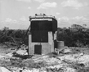
- Southern Searchlight: This two-story building is rectangular. The ground floor was for the generator. The first floor was open to the sea for the searchlight.
- No.2 Gun Emplacement: This is similar to the No.1 Gun Emplacement. However, a fire caused the timber roof to collapse. It's mostly a single-story structure now. The ground floor is still mostly intact, with a clearer duty roster on the wall.
- Northerly Mine Control Hut: This single-story concrete building is mostly buried in the sand dune. It was used by the Royal Australian Navy to control underwater mines.
- Southerly Mine Control Hut: This is a larger, square concrete building, also mostly buried in the sand dune. It also controlled mines.
- Northern Searchlight: This is like the Southern Searchlight but is now on the beach, close to the high tide. It probably used to be further back from the water.
- Battery Observation Post: This structure was originally about 15 meters tall. It was used to watch ships in the bay. It's on top of the first sand dune. It had a special rangefinder to measure distances.
- Signals Operations Room: This concrete building is behind the first sand dune. It seems it was originally buried in the dune. It has a large hole in one wall.
Camp Area Remains
Many old building locations have been found. They include:
- Camp Area: Concrete slabs from the Officer's Mess and Kitchen. Also, concrete stumps and steps from the Command Post and other buildings.
- Men's Latrines: A concrete slab with rows of toilets that have been broken. There are also concrete trough urinals.
- Pump House: A square concrete structure in the ground. It's filled with water, so it's hard to see what's inside.
- Sewerage Treatment Works: A tall concrete structure with chambers for treating sewage.
- Power House: A rectangular concrete slab with two raised platforms for generators.
Skirmish Point Battery Remains
Most of the Skirmish Point Battery has been lost due to erosion. The gun emplacements and searchlights were once close to the beach.
- Fortress Observation Post: This is the only part of the Skirmish Point Battery that remains. It's about 4-5 km north of the main battery area. It used to be on tall timber stumps but now rests on its side. It's a concrete box with an opening to the east, where readings were taken.
RAN Station No.4 was built within the Skirmish Point Battery area. There are three concrete structures left.
- Naval Control Post: This single-story building is on top of the first sand dune. It has a long corner window with a view to the northeast. The inside is covered in graffiti.
- Southerly Engine Room: This single-story, single-room building is in a park behind the first dune. It has been painted green.
- Northerly Engine Room: This is similar to the Southerly Engine Room. It's in the bushes north of a car park.
Why Are These Forts Important?
The Bribie Island Second World War Fortifications are listed on the Queensland Heritage Register because they are very important for several reasons:
- Showing Queensland's History: They show how Queensland prepared its defenses during the 1930s and World War II.
- Learning About the Past: There are many remains of these forts. They can help us learn more about Queensland's history during the war.
- Examples of Fortifications: They are great examples of Australia's coastal defense forts from World War II.
- Beautiful and Unique: The forts at Fort Bribie have a special feeling of isolation. The overgrown landscape makes them feel like a discovery. The design and materials of all the forts are also important. Their locations make them stand out.
- Connecting to War Efforts: They have a strong link to the defense efforts of the Australian Military Force and Royal Australian Navy during World War II.
 | Bessie Coleman |
 | Spann Watson |
 | Jill E. Brown |
 | Sherman W. White |


