Bribie Island North facts for kids
Quick facts for kids Bribie Island NorthQueensland |
|||||||||||||||
|---|---|---|---|---|---|---|---|---|---|---|---|---|---|---|---|

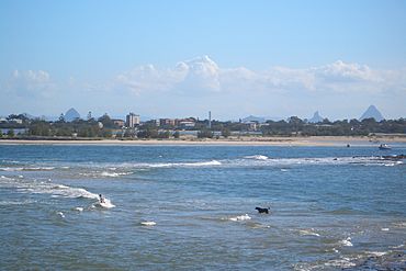
The northern tip of Bribie Island is not far from Caloundra. The Glass House Mountains can be seen in the background
|
|||||||||||||||
| Population | 0 (2021 census) | ||||||||||||||
| • Density | 0/km2 (0/sq mi) | ||||||||||||||
| Postcode(s) | 4507 | ||||||||||||||
| Area | 46.6 km2 (18.0 sq mi) | ||||||||||||||
| Time zone | AEST (UTC+10:00) | ||||||||||||||
| LGA(s) | Sunshine Coast Region | ||||||||||||||
| State electorate(s) | Caloundra | ||||||||||||||
| Federal Division(s) | Longman | ||||||||||||||
|
|||||||||||||||
Bribie Island North is a special area located on Bribie Island in Queensland, Australia. It's part of the Sunshine Coast Region. This northern tip is unique because it's the only part of Bribie Island that belongs to the Sunshine Coast. The rest of the island is part of the City of Moreton Bay.
Even though it's a named place, Bribie Island North doesn't have any people living there. In the 2021 census, it was recorded as having "no people or a very low population".
Contents
Exploring the Geography of Bribie Island North

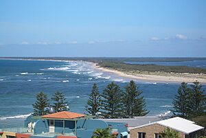
As its name suggests, Bribie Island North is the very top part of Bribie Island. It's like a long, thin finger of land. On its western side, it's separated from the mainland by a very narrow waterway called the Pumicestone Passage. To the east, it faces the wide open Pacific Ocean.
What is a Sandspit?
The northern end of Bribie Island North tapers into a long, low, and narrow sandspit. A sandspit is a natural landform made of sand or mud that extends into a body of water.
The Dynamic Pumicestone Passage
The Pumicestone Passage in this area is very narrow and shallow, often less than 2 meters deep. It has sand and mud banks that are always moving. This means the sandspit's shape changes a lot due to natural processes like sand building up and washing away.
During big storms, ocean waves can sometimes crash over the sandspit from the Coral Sea into the calmer Pumicestone Passage. There's a chance these powerful waves could even break through the sandspit. If this happens, new openings to the Pumicestone Passage would be created.
Impact on Nearby Towns
New openings could affect nearby towns like Golden Beach and Pelican Waters in Caloundra. These towns would then be more directly exposed to the stronger waves from the Coral Sea. Currently, they are protected by the calmer waters of the Pumicestone Passage.
Bribie Island National Park
Most of Bribie Island North is undeveloped land. It's part of the beautiful Bribie Island National Park. This park helps protect the natural environment and wildlife of the area.
History of Bribie Island North
In December 2020, strong weather caused changes to the northern sandspit. The wild weather started creating channels from the ocean directly through the sandspit into the Pumicestone Passage. This shows how powerful nature can be in shaping coastlines.
Heritage Sites
Bribie Island North has some important historical places. These are known as heritage sites. One significant site is the Bribie Island Second World War Fortifications. These are old military structures built during World War II to defend the coast.
 | Kyle Baker |
 | Joseph Yoakum |
 | Laura Wheeler Waring |
 | Henry Ossawa Tanner |


