
Glass House Mountains facts for kids
Quick facts for kids Glass House Mountains |
|
|---|---|

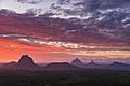
Aerial photo of Glass House Mountains township with the Glass House Mountains in the distance
|
|
| Highest point | |
| Peak | Mount Beerwah |
| Elevation | 556 m (1,824 ft) |
| Geography | |

Glass House Mountains
Location in Queensland
|
|
| Country | Australia |
| State | Queensland |
| Region | South East Queensland |
| Geology | |
| Formed by | Volcanic plugs |
| Age of rock | Tertiary |
The Glass House Mountains are a group of thirteen hills that stand tall on the Sunshine Coast in Queensland, Australia. The tallest is Mount Beerwah, reaching 556 metres high. But the most famous is Mount Tibrogargan, which looks like a face gazing out to sea.
These mountains are close to Beerburrum State Forest and Steve Irwin Way. You can reach them from Brisbane by driving north on the Bruce Highway. The trip takes about one hour. These dramatic peaks were formed by ancient volcanoes. About 26 to 27 million years ago, hot, melted rock pushed up from underground. This rock then cooled and hardened. Over millions of years, wind and rain wore away the softer rock around these hard cores. This left behind the amazing mountains we see today.
Explorer Lieutenant James Cook named the mountains on May 17, 1770. He thought the peaks looked like the glass furnaces from his home in Yorkshire. Later, in 1799, Matthew Flinders explored the area. He even climbed Mount Beerburrum after sailing along Pumicestone Passage. The Glass House Mountains were added to the Australian National Heritage List on August 3, 2006. This means they are very important to Australia's history and nature. Between the mountains, people farm pineapples and poultry. They also do commercial forestry and quarrying. In 2009, the Glass House Mountains were named one of the Q150 Icons of Queensland. This was part of the state's 150th birthday celebrations.
Contents
How the Mountains Were Formed
The Glass House Mountains were created from melted lava. This lava cooled and became hard rock inside volcanoes about 26 to 27 million years ago. The lava came from a very hot spot deep under eastern Australia. The hard rock inside the hills is called comendite. This rock formed when the lava cooled quickly. Over time, the softer rocks around these hard cores wore away. This left behind the amazing volcanic plugs we see today. The mountains are lined up in a certain way. Scientists believe this happened because of cracks in the Earth's crust.
The Famous Peaks


Each of the mountains is protected inside the Glass House Mountains National Park. Some of the peaks have tall, straight columns. You can see these on Mount Coonowrin, Mount Ngungun, and Mount Beerwah. These columns formed as the lava cooled and shrank. There are also small caves scattered around the hills. These caves were made by wind wearing away rocks that were softened by water.
The peaks are very important to the local Gubbi Gubbi people. They are considered spiritual places. Because of this, access to some peaks might be limited in the future. There is also an Aboriginal bora ring near the Glass House Mountains township.
Here are the names of the mountains in the range:
- Mount Beerburrum, 278 m
- Mount Beerwah, 556 m
- Mount Coochin or The Coochin Hills, 235 m and 230 m
- Mount Coonowrin or Crookneck, 377 m
- Mount Elimbah or The Saddleback, 109 m
- Mount Ngungun, 253 m
- Mount Tibberoowuccum, 220 m
- Mount Tibrogargan and Cooee, 364 m and 177 m
- Mount Tunbubudla or the Twins, 338 m and 294 m
- Wild Horse Mountain, 123 m
- Mount Miketeebumulgrai: 199 m
- Mount Ninderry: 155 m
- Mount Coolum: 208 m
Aboriginal Culture and Legends
The Glass House Mountains are on the traditional lands of the Jinibara and Gubbi Gubbi people. These First Nations Australians have many old stories and legends about the mountains. These stories explain how the mountains came to be and their special meaning.
Visiting the Mountains
Queensland National Parks manages the mountains. They are a popular place for tourists to visit. People have been bushwalking and climbing here for over a hundred years. However, the two largest mountains have been closed by National Parks in recent years.
Mount Coonowrin was closed in 1999. This was due to a geological report and a nearby rock quarry. The walking track to Mount Beerwah was closed in 2009. This happened after rocks fell from a cave area onto the main path. It was reopened in January 2016. Mount Tibrogargan and Mount Ngungun are open for bushwalking and climbing.
The Beerwah and Tibrogargan mountains are very important to the local Jinibara and Kabi Kabi people. They hold "sacred values" for them. Because of this, these groups ask visitors not to climb these mountains.
Plants and Animals
The Glass House Mountains are home to many different kinds of plants. You can find trees, grasses, bushes, and shrubs. Many animals also live here. These include birds, reptiles, frogs, bats, and small mammals like rats and cats. A tiny lizard called the Elf Skink also lives in this area.
Images for kids
-
Sacred Site Mountain View

See also
 In Spanish: Montañas Glass House para niños
