
Beerburrum, Queensland facts for kids
Quick facts for kids BeerburrumSunshine Coast, Queensland |
|||||||||||||||
|---|---|---|---|---|---|---|---|---|---|---|---|---|---|---|---|
.jpg)
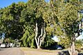
Anzac Avenue (main street of Beerburrum) with its memorial avenue of trees, 2007
|
|||||||||||||||

Beerburrum
Location in Queensland
|
|||||||||||||||
| Population | 941 (2021 census) | ||||||||||||||
| • Density | 9.792/km2 (25.36/sq mi) | ||||||||||||||
| Postcode(s) | 4517 | ||||||||||||||
| Area | 96.1 km2 (37.1 sq mi) | ||||||||||||||
| Location |
|
||||||||||||||
| LGA(s) | Sunshine Coast Region | ||||||||||||||
| County | Canning | ||||||||||||||
| Parish | Beerwah | ||||||||||||||
| State electorate(s) | Glass House | ||||||||||||||
| Federal Division(s) | Fisher | ||||||||||||||
|
|||||||||||||||
Beerburrum is a small town and area located in the Sunshine Coast Region of Queensland, Australia. It's a rural place, meaning it's mostly countryside. In 2021, about 941 people lived in Beerburrum.
Contents
Exploring Beerburrum's Location
Beerburrum is about 60 kilometers (37 miles) north of Brisbane, Queensland's capital city. A major road called the Bruce Highway passes nearby. The North Coast railway line also runs through the area. You can find the Beerburrum railway station on the eastern side of the town.
Islands and Waterways
The area includes some undeveloped islands in the Pumicestone Passage. This is a narrow waterway between the mainland and Bribie Island. Some of these islands are called Long Island and Thooroola Island. The eastern part of Beerburrum is low and has many creeks. These creeks flow into the Pumicestone Passage.
Mountains and Nature
The western part of Beerburrum is hillier. It is home to two of the famous Glass House Mountains: Mount Beerburrum and Mount Tibberoowuccum. Both of these mountains are protected within the Glass House Mountains National Park.
Mount Beerburrum
Mount Beerburrum is a mountain that rises to 280 meters (919 feet) above sea level. It has a special kind of rainforest with some rare plants. These include trees like Tindal's stringybark and Pink bloodwood. There's also a forestry fire tower at the top of the mountain. It has a viewing platform where you can enjoy amazing views!
Mount Tibberoowuccum
Mount Tibberoowuccum is another mountain, about 220 meters (722 feet) high. It looks like a dome-shaped rock. This mountain is surrounded by eucalyptus forests and some rainforest. You can find a rare shrub called Narrow-leaf bitter-pea here. It's usually found in other parts of Australia, but this is the most northern place it's known to grow.
A Look Back: Beerburrum's History


The name Beerburrum comes from the mountain. In the language of the local Kabi nation, bir means green parrot and burru means mountain.
Early European Visitors
In 1799, Matthew Flinders, a famous explorer, climbed Mount Beerburrum. He was with two sailors and an Aboriginal man named Bongaree. They were the first Europeans to climb one of the Glass House Mountains.
Thomas Martin Tripcony was one of the first European settlers in the area. In 1861, he chose land along the Pumicestone Passage. He made a living by collecting oysters and burning lime. Later, he built a family home there in 1877.
The Railway Arrives
The North Coast railway line reached Beerburrum in 1890. This made it easier for people to travel to and settle in the area. A cemetery was also started around 1908.
Soldier Settlement Scheme
In 1916, Beerburrum became a special place for a "soldier settlement." After World War I, the government wanted to help soldiers. They divided over 24,000 hectares (59,000 acres) into more than 550 small farms. This was the largest soldier settlement in Queensland. The idea was for soldiers to grow pineapples and other fruits.
However, by 1929, the plan didn't work out as hoped. The farms were too small to make enough money. Also, the soldiers often didn't have enough farming skills or money to start. Many of these settlements across Australia faced similar problems.
Town Development
- The Beerburrum Post Office opened by 1917.
- Beerburrum State School opened on April 22, 1918.
- The Beerburrum School of Arts, a community hall, opened in May 1918.
- Around 1920, a special avenue of trees was planted in the main street. This was to remember the soldiers who served in World War I. The street was then renamed Anzac Avenue.
- The Beerburrum Bakery opened around 1920. It's one of the few buildings from the soldier settlement that is still standing today.
- A small hospital opened in 1922 but closed in 1931 when the settlement struggled.
- An Anglican church, St George's, was moved from an army barracks to Beerburrum in 1922. But it also closed in 1931 and was moved again to Maleny.
After World War II
After World War II, pine tree plantations were grown in the area. This created a local forestry industry. A special barracks was built around 1947 to house forestry workers. The main highway has also changed its path around Beerburrum over the years.
How Many People Live Here?
The population of Beerburrum has grown over time:
- In 2006, there were 287 people.
- In 2011, there were 600 people.
- In 2016, there were 763 people.
- In 2021, the population reached 941 people.
Special Places: Heritage Listings
Beerburrum has several places that are important to its history. These are called "heritage-listed" sites. They include:
- The Anzac Avenue Memorial Trees
- The Beerburrum Bakery on Anzac Avenue
- The Beerburrum School of Arts Hall
- The Beerburrum Cemetery
- The Beerburrum Forestry Station Barracks
- The Campbellville Settlement and Cemetery
- The Cowriebank Site near Pumicestone Passage
Learning and Community

Beerburrum State School
Beerburrum State School is a government primary school for students from Prep (the first year of school) to Year 6. It's located at 8 Beerburrum Road. In 2017, about 92 students attended the school.
There are no high schools in Beerburrum itself. Older students usually go to secondary schools in nearby towns like Beerwah, Woodford, or Caboolture.
Local Amenities
The Sunshine Coast Regional Council provides a mobile library service that visits the school. The Beerburrum School of Arts at 7 Anzac Avenue is a community hall. It can hold up to 100 people for events and gatherings.
Getting Around: Transport
The Beerburrum railway station is an important stop on the North Coast railway line. This line connects Brisbane all the way to Cairns. There are also bus routes operated by Translink that help people travel within Beerburrum and the surrounding Sunshine Coast Hinterland.
Images for kids
-
Anzac Avenue (main street of Beerburrum) with its memorial avenue of trees, 2007
-
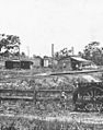
Looking towards the railway station, Beerburrum, 1916
-
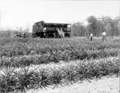
Soldiers farm, Beerburrum, 1918
-

Beerburrum State School, 1918
