County of Canning facts for kids
Quick facts for kids CanningQueensland |
|||||||||||||||
|---|---|---|---|---|---|---|---|---|---|---|---|---|---|---|---|

Location within Queensland
|
|||||||||||||||
|
|||||||||||||||
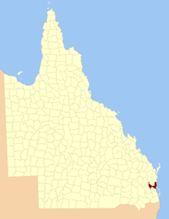
The County of Canning is a special kind of area in Queensland, Australia. It's like an old-fashioned way of dividing land for official records, called a cadastral division. This county covers most of the areas that used to be the Shires of Caboolture, Maroochy, and Kilcoy, plus the former City of Caloundra. Today, its main towns and busy areas are found along the Sunshine Coast (but not Noosa) and around Caboolture.
Contents
The Story of Canning County
The County of Canning was first officially created a long time ago, on December 30, 1848. This happened through a special order from the Governor of New South Wales. It was named to honor Sir George Canning. He was an important British politician who served as the country's top diplomat, the Foreign Secretary. For a short time, he was even the Prime Minister.
Original Boundaries in 1848
When it was first created, Canning County was described as being about 1330 square miles. Its eastern side followed the sea-coast, including part of Bribie Island. To the north, it stretched along the Maroochydore River to its source. From there, it followed a mountain range that separated the waters flowing into the Mary River from those flowing into the Brisbane River. The southern boundary was set by the 27th parallel of south latitude.
Changes to Boundaries in 1901
Later, on March 7, 1901, the Governor of Queensland announced new boundaries for the county. This was done under a law called the Land Act 1897. The southern border was changed from the 27th parallel to the Caboolture River. The northern border was also extended further north, reaching the boundary of the Shire of Noosa.
What are Parishes?
Counties like Canning are often divided into smaller areas called parishes. These divisions help with land administration and record-keeping. The County of Canning includes several parishes, each with its own towns and locations. For example, the Beerwah parish is home to the towns of Beerwah and Beerburrum. Another parish, Maroochy, includes places like Nambour and Coolum.
 | May Edward Chinn |
 | Rebecca Cole |
 | Alexa Canady |
 | Dorothy Lavinia Brown |

