County of Fitzroy, Queensland facts for kids
Quick facts for kids FitzroyQueensland |
|||||||||||||||
|---|---|---|---|---|---|---|---|---|---|---|---|---|---|---|---|

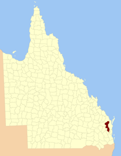
Location within Queensland
|
|||||||||||||||
|
|||||||||||||||
The County of Fitzroy is a special type of land division in Queensland, Australia. It's called a "cadastral division," which means it's used mainly for keeping track of land ownership and property records. It doesn't have its own government or local council like a city or town.
Contents
About Fitzroy County
Fitzroy County covers the eastern and central parts of the South Burnett Region. It also includes a section of the former Shire of Kilkivan in the Gympie Region. This area is important for land administration in Queensland.
How Fitzroy County Got Its Name
The county was named in the 1850s by the Surveyor-General of New South Wales. It was named after Charles Augustus FitzRoy. He was the Governor of New South Wales from 1848 to 1855.
The County of Fitzroy was officially given its name and boundaries on March 7, 1901. This was done by the Governor in Council under the Land Act 1897. It's important to know that this county is not connected to the Fitzroy River. That river is located in a different area, around the County of Livingstone.
Parishes in Fitzroy County
Fitzroy County is further divided into smaller areas called parishes. These parishes also help with land records. Here is a list of the parishes within Fitzroy County:
| Parish | LGA | Coordinates | Towns |
|---|---|---|---|
| Barambah | South Burnett | 26°19′S 152°05′E / 26.317°S 152.083°E | Moffatdale |
| Booie | South Burnett | 26°32′S 152°00′E / 26.533°S 152.000°E | |
| Boonenne | South Burnett | 26°35′S 151°44′E / 26.583°S 151.733°E | Kingaroy, Inverlaw |
| Charlestown | South Burnett | 26°25′S 151°56′E / 26.417°S 151.933°E | |
| Cherbourg | South Burnett | 26°19′S 151°56′E / 26.317°S 151.933°E | Cherbourg |
| Cloyna | South Burnett | 26°08′S 151°53′E / 26.133°S 151.883°E | Cloyna |
| Coolabunia | South Burnett | 26°37′S 151°59′E / 26.617°S 151.983°E | Coolabunia |
| Gallangowan | Gympie | 26°27′S 152°17′E / 26.450°S 152.283°E | |
| Goomeribong | Gympie | 26°12′S 152°04′E / 26.200°S 152.067°E | Goomeri |
| Haly | South Burnett | 26°46′S 151°37′E / 26.767°S 151.617°E | |
| Johnstown | South Burnett | 26°25′S 152°06′E / 26.417°S 152.100°E | |
| Kunioon | South Burnett | 26°41′S 151°52′E / 26.683°S 151.867°E | Goodger |
| Manumbar | Gympie | 26°22′S 152°18′E / 26.367°S 152.300°E | Manumbar |
| McEuen | South Burnett | 26°18′S 151°50′E / 26.300°S 151.833°E | Wondai, Tingoora |
| Mondure | South Burnett | 26°12′S 151°45′E / 26.200°S 151.750°E | Hivesville |
| Murgon | South Burnett | 26°13′S 151°55′E / 26.217°S 151.917°E | Murgon |
| Nanango | South Burnett | 26°41′S 151°59′E / 26.683°S 151.983°E | Nanango |
| Neumgna | South Burnett | 26°53′S 151°48′E / 26.883°S 151.800°E | |
| Taabinga | South Burnett | 26°41′S 151°42′E / 26.683°S 151.700°E | Kumbia |
| Tarong | South Burnett | 26°47′S 151°50′E / 26.783°S 151.833°E | Brooklands |
| Tureen | South Burnett | 26°50′S 151°40′E / 26.833°S 151.667°E | |
| Wooroolin | South Burnett | 26°28′S 151°46′E / 26.467°S 151.767°E | Kingaroy, Wooroolin |
External links
 | Emma Amos |
 | Edward Mitchell Bannister |
 | Larry D. Alexander |
 | Ernie Barnes |

