Signal Station, Moreton Island facts for kids
Quick facts for kids Signal Station, Moreton Island |
|
|---|---|

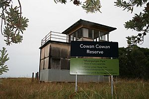
Signal Station, 2006
|
|
| Location | 25 Dorothy Newnham Street, Moreton Island, City of Brisbane, Queensland, Australia |
| Design period | 1919–1930s (interwar period) |
| Built | 1930s |
| Official name: Signal Station (former), Former Navy Signal Station Fort Cowan | |
| Type | state heritage (built, archaeological) |
| Designated | 1 February 1995 |
| Reference no. | 601097 |
| Significant period | 1930s (fabric) 1930s-1960s (historical) |
| Significant components | slab/s – concrete |
| Lua error in Module:Location_map at line 420: attempt to index field 'wikibase' (a nil value). | |
The Signal Station, Moreton Island is a special old building with a lot of history. It's located at 25 Dorothy Newnham Street on Moreton Island, Queensland, Australia. Built in the 1930s, it was once known as the Former Navy Signal Station Fort Cowan. This important site was added to the Queensland Heritage Register on February 1, 1995, because of its role in guiding ships and helping defend Australia.
Contents
A Look Back: The Signal Station's Story
The Signal Station was likely built in the late 1930s by the Royal Australian Navy. In 1947, the Queensland Government took it over. This building was the second signal station used at Cowan Cowan, on the western side of Moreton Island.
Early Ship Routes in Moreton Bay
When Moreton Bay was a penal settlement (a place for prisoners), ships mostly entered through the South Entrance. This was the passage between Moreton and North Stradbroke Island. The first navigation aids, like markers for ships, were put in Moreton Bay in 1825. A Pilot Station was set up at Amity Point on North Stradbroke Island by 1827.
However, the South Entrance was tricky and dangerous for ships. In the 1830s, people started thinking about using the northern entrance instead. But the southern entrance stayed the main one because it suited the colony better. Its markers were already in place, and the pilot station was already at Amity Point.
Moreton Bay Opens Up
In 1842, Moreton Bay became a free settlement. This meant more ships started coming and going. Brisbane was declared a major port in 1846.
By the mid-1840s, both the north and south entrances were being used. New surveys were done in 1846, and buoys (floating markers) were placed in the northern entrance. Sailing directions for the northern entrance were published in 1847. This was to prepare for the southern passage closing as the main way into the Bay.
After a ship called the Sovereign sank in 1847, a harbour master was appointed for Brisbane. More buoys were added to make the northern entrance clearer. In 1848, the pilot station moved from Amity Point. It first went to Cowan Cowan, then to Bulwer on Moreton Island. This pilot station was the first official European settlement on Moreton Island.
The Signal Station Moves to Cowan Cowan
The pilot station at Bulwer closed in 1909. Only the signalman, who also managed the telephone station, remained. In 1912, the Signal Station moved to Cowan Cowan. This location was better for ships using the North West Channel. This channel had been declared the safest way into Moreton Bay in the 1890s.
The channel had a Z-shaped route. It ran close to the shore near Caloundra, then across the bar towards Moreton Island, and then southwesterly towards the river mouth. By the mid-1940s, the Signal Station building that had moved from Bulwer was in bad shape. The coastline was eroding, putting the building at risk of falling into the sea.
Protecting Queensland During World War II
Fort Cowan Cowan was built north of the Signal Station in the late 1930s. It was part of a defense system for southeast Queensland during the Second World War. Other forts were built around Moreton Bay, including at Caloundra, Bribie Island, and Rous on Moreton Island. These, along with Fort Lytton, created a network of defense batteries.
The shipping channels in Moreton Bay made it easier to decide where to place these batteries. The North West Channel was still the main way into the Brisbane River. This meant the best spots for guns were closest to the channel bends. Fort Cowan took over the job of an "Examination Battery" from Fort Lytton.
A Port War Signal Station (PWSS), also called the Naval Signal Station, was built for this duty. The Examination Service identified ships trying to enter defended ports. This was important to know if any suspicious or unfriendly vessels were approaching. The Naval Signal Station's main job was to receive signals from Examination Vessels and send messages to the gunners. It didn't usually send signals itself, to avoid revealing the battery's location.
After the War: A New Purpose
All PWSSs closed after September 1945. In 1946, the Department of Public Works in Queensland wanted to buy the former Naval Signal Station. Their own Signal Station was in disrepair. They decided it was best to keep the building where it was. Moving it might damage its walls and roof. The location also had a great view of the Bay.
The former Naval Signal Station, its mast, and a house were bought by the Queensland Government in May 1947.
In 1954, the Postmaster-General's Department (PMG) wanted to set up a radio telephone service between Brisbane and Cowan Cowan. They considered using the former Naval Signal Station for their equipment. However, the building was too big for their needs. The radio telephone equipment was placed in the Signal Station.
The Station Closes
In the early 1960s, VHF radio communication for ships became common. This meant signal stations were no longer as needed. The Signal Station closed in December 1960. The lighthouse, which had become automatic in 1950, continued to work on its own.
The Wadsworths, who lived nearby, were allowed to use part of the Signal Station building in 1967. The Australian Telecommunications Commission removed the radio telephone equipment in 1976.
After the Wadsworths passed away, the Brisbane City Council suggested the land become a recreation reserve. In 1989, it was officially made a Reserve for Local Government (Historical Park and Recreation) Purposes. The timber stairs to the upper level of the building were removed in 1990. The radio mast was moved to the Enoggera Army Barracks in 1993 because it had termites.
What the Signal Station Looks Like
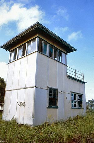
The Signal Station is a two-story building on the western side of Moreton Island at Cowan Cowan. It sits behind the first sand dune, looking out over the beach and the shipping channel. North along the beach, you can still see parts of old concrete gun emplacements.
It's a small building made of timber, shaped like a rectangle. It stands on low concrete stumps. The walls, both inside and out, are covered with asbestos cement sheets. On the southeast corner, there's a double row of stumps leading to a timber door. This shows where the entry steps used to be.
This door opens into the lower level, which has two rooms connected by a door. These rooms have timber floors and double-hung timber windows with bars and screens.
The upper level also has two parts. It has a single room with a hip roof and a roof terrace. You can't get to this upper level anymore because the external staircase, which was on the eastern side, has been removed. The room has windows all around its walls, with two doorways. One doorway would have been at the top of the old stairs. Another doorway in the middle of the southern wall opens onto the roof terrace.
Around the Signal Station, you can find several small concrete slabs and other remains in the grass.
Why the Signal Station is Important
The former Signal Station was added to the Queensland Heritage Register on February 1, 1995, for several reasons:
- It shows how Queensland's history developed.
The Signal Station helps us understand the important role Cowan Cowan and Moreton Island played in guiding ships in Moreton Bay. This goes back to the mid-19th century when the pilot station moved to Moreton Island.
- It represents a specific type of historic place.
This former Naval Signal Station was part of Fort Cowan and the Cowan Cowan Battery. It shows how Queensland was defended during the Second World War by the Australian military, especially the Royal Australian Navy. It's also important as part of a network of defense batteries around Moreton Bay.
 | James B. Knighten |
 | Azellia White |
 | Willa Brown |


