County of Ward, Queensland facts for kids
Quick facts for kids WardQueensland |
|||||||||||||||
|---|---|---|---|---|---|---|---|---|---|---|---|---|---|---|---|

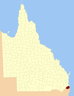
Location within Queensland
|
|||||||||||||||
|
|||||||||||||||
The County of Ward is a special area in the southeastern part of Queensland, Australia. Think of it like a really big district used for keeping land records. The famous city of the Gold Coast is mostly found here. It also includes southern parts of the West Moreton area, with towns like Beaudesert and Boonah.
Contents
The History of Ward County
How Ward County Was Created
Ward County was first officially created a long time ago, on December 30, 1848. This happened through a special decision made by the Governor of New South Wales. At that time, Queensland was still part of New South Wales.
The original description of Ward County was:
County of Ward, containing about 1105 square miles. Bounded on the south by the range which runs from Point Danger to Mount Lindesay, and thence to Wilsons Peak on the Great Dividing Range; on the north-west by the range which divides the waters of the Teviot from those of the Bremer, until it meets the 28th parallel of south latitude; on the north by that parallel; and on the east by the sea-coast to Point Danger.
This means its borders were set by natural features like mountain ranges and the coastline. The county covered about 1105 square miles.
Changes to Ward County's Borders
When Queensland became a separate colony from New South Wales in 1859, the southern border of Ward County became part of Queensland's new southern border.
Later, on March 7, 1901, the Governor of Queensland announced new boundaries for the county. These new borders were set under a law called the Land Act 1897.
The new description of the county's borders was:
Commencing at Point Danger, and bounded thence on the south by the southern boundary of the State; on the west by the western boundaries of the parishes of Alford, Coochin and Dugandan; on the north by Woollaman Creek and the Logan River; and on the east by Moreton Bay, the Broadwater and the Pacific Ocean.
This updated description made the boundaries clearer.
Parishes Within Ward County
Just like all counties in Queensland, Ward County is divided into smaller areas called parishes. These parishes help with mapping and managing land. The table below shows each parish, the local government area it belongs to, its approximate location coordinates, and some of the towns found within it.
| Parish | LGA | Coordinates | Towns |
|---|---|---|---|
| Albert | Gold Coast | 27°46′S 153°18′E / 27.767°S 153.300°E | Alberton, Ormeau (East), Woongoolba |
| Alford | Scenic Rim | 28°11′S 152°33′E / 28.183°S 152.550°E | |
| Barrow | Gold Coast | 27°56′S 153°20′E / 27.933°S 153.333°E | Paradise Point, Oxenford |
| Beaudesert | Scenic Rim | 28°03′S 152°59′E / 28.050°S 152.983°E | Beaudesert, Laravale |
| Boonnahbah | Gold Coast | 27°46′S 153°24′E / 27.767°S 153.400°E | |
| Boyd | Logan | 27°44′S 153°11′E / 27.733°S 153.183°E | Beenleigh, Bethania, Windaroo |
| Bromelton | Scenic Rim | 27°59′S 152°53′E / 27.983°S 152.883°E | Bromelton |
| Cedar | Gold Coast | 27°56′S 153°15′E / 27.933°S 153.250°E | Tamborine Mountain, Upper Coomera |
| Coochin | Scenic Rim | 28°06′S 152°38′E / 28.100°S 152.633°E | Boonah, Mount Alford |
| Coomera | Gold Coast | 27°52′S 153°21′E / 27.867°S 153.350°E | Coomera |
| Currigee | Gold Coast | 27°50′S 153°26′E / 27.833°S 153.433°E | South Stradbroke Island |
| Darlington | Gold Coast | 27°48′S 153°12′E / 27.800°S 153.200°E | Ormeau (West) |
| Dugandan | Scenic Rim | 27°56′S 152°47′E / 27.933°S 152.783°E | |
| Gilston | Gold Coast | 28°04′S 153°21′E / 28.067°S 153.350°E | Broadbeach, Burleigh Heads |
| Jimboomba | Logan | 27°51′S 153°02′E / 27.850°S 153.033°E | Jimboomba |
| Kerry | Scenic Rim | 28°09′S 153°04′E / 28.150°S 153.067°E | Kerry |
| Knapp | Scenic Rim | 28°08′S 152°48′E / 28.133°S 152.800°E | Rathdowney |
| Logan | Logan | 27°54′S 153°00′E / 27.900°S 153.000°E | Woodhill |
| Melcombe | Scenic Rim | 28°14′S 152°38′E / 28.233°S 152.633°E | |
| Moffatt | Logan | 27°47′S 153°06′E / 27.783°S 153.100°E | Logan Village, Waterford |
| Mudgeeraba | Gold Coast | 28°08′S 153°22′E / 28.133°S 153.367°E | Mudgeeraba |
| Mundoolun | Logan | 27°54′S 153°04′E / 27.900°S 153.067°E | Mundoolun |
| Nerang | Gold Coast | 27°59′S 153°22′E / 27.983°S 153.367°E | Nerang, Southport, Carrara |
| Nindooinbah | Scenic Rim | 28°03′S 153°04′E / 28.050°S 153.067°E | |
| Numinbah | Gold Coast | 28°11′S 153°15′E / 28.183°S 153.250°E | Numinbah Valley, Springbrook |
| Palen | Scenic Rim | 28°16′S 152°46′E / 28.267°S 152.767°E | |
| Pimpama | Gold Coast | 27°49′S 153°18′E / 27.817°S 153.300°E | Pimpama |
| Roberts | Scenic Rim | 28°14′S 153°08′E / 28.233°S 153.133°E | |
| Sarabah | Scenic Rim | 28°06′S 153°07′E / 28.100°S 153.117°E | |
| Tabragalba | Scenic Rim | 27°59′S 153°07′E / 27.983°S 153.117°E | Canungra |
| Tallebudgera | Gold Coast | 28°10′S 153°26′E / 28.167°S 153.433°E | Palm Beach, Coolangatta |
| Tamborine | Scenic Rim | 27°55′S 153°09′E / 27.917°S 153.150°E | Tamborine |
| Tamrookum | Scenic Rim | 28°04′S 152°49′E / 28.067°S 152.817°E | Tamrookum |
| Telemon | Scenic Rim | 28°14′S 152°58′E / 28.233°S 152.967°E | |
| Teviot | Scenic Rim | 27°53′S 152°56′E / 27.883°S 152.933°E | |
| Wickham | Logan | 27°49′S 153°09′E / 27.817°S 153.150°E | |
| Witheren | Scenic Rim | 28°04′S 153°11′E / 28.067°S 153.183°E | Beechmont, Witheren |
 | Audre Lorde |
 | John Berry Meachum |
 | Ferdinand Lee Barnett |

