
Springbrook, Queensland facts for kids
Quick facts for kids SpringbrookGold Coast, Queensland |
|||||||||||||||
|---|---|---|---|---|---|---|---|---|---|---|---|---|---|---|---|

Springbrook Plateau (left of image)
|
|||||||||||||||

Springbrook
Location in Gold Coast, Australia
|
|||||||||||||||
| Population | 705 (2021 census) | ||||||||||||||
| • Density | 13.378/km2 (34.65/sq mi) | ||||||||||||||
| Established | 1906 | ||||||||||||||
| Postcode(s) | 4213 | ||||||||||||||
| Area | 52.7 km2 (20.3 sq mi) | ||||||||||||||
| Time zone | AEST (UTC+10:00) | ||||||||||||||
| Location |
|
||||||||||||||
| LGA(s) | City of Gold Coast | ||||||||||||||
| State electorate(s) | Mudgeeraba | ||||||||||||||
| Federal Division(s) | McPherson | ||||||||||||||
|
|||||||||||||||
Springbrook is a small town and area in Queensland, Australia. It is located in the City of Gold Coast and shares a border with New South Wales.
In 2021, about 705 people lived in Springbrook.
Contents
Exploring Springbrook's Geography
Springbrook is known for its beautiful subtropical rainforests. Many small creeks flow through the area. You can enjoy amazing views of the Gold Coast from here. The area is famous for its tall cliffs, stunning waterfalls, and forest walking trails. Most of these natural wonders are protected within the Springbrook National Park.
You can reach this mountain area by road from Mudgeeraba using Springbrook Road. Another way is from Numinbah Valley via Pine Creek Road. To the south of Springbrook is the Tweed Range. To the west is the Numinbah Valley and the Lamington Plateau.
The Nimmel Range and Tamborine Mountain are to the north. The Hinze Dam, an important water source, is also nearby. The peak of Mount Nimmel is at the northeastern tip of the area. Springbrook is a special place with lots of different plants and animals. It is also an important area for birds. You might often see Pademelons, which are small wallabies, when you visit.
How Springbrook Was Formed
The Springbrook Plateau is what remains of an ancient volcano called the Tweed Volcano. This volcano is now known as Mount Warning and the Tweed Valley. The plateau is a high, wavy area that stretches north from the southern, forested hills near Mount Cougal.
These subtropical rainforests are part of the Gondwana Rainforests of Australia. They are home to rare Antarctic beech trees. Springbrook plateau has been called "the Switzerland of Queensland" because of its unique beauty. It is now seen as a distinct plateau landform.
You can easily see the Springbrook Plateau from the Gold Coast coastline. It is part of the water catchment area for Tallebudgera Creek and the larger Nerang River. The Nerang River is dammed by the Hinze Dam, which provides a lot of water for the region. Little Nerang Creek flows into Little Nerang Dam ([//geohack.toolforge.org/geohack.php?pagename=Springbrook%2C_Queensland¶ms=28.1477_S_153.2841_E_type:waterbody_region:AU-QLD&title=Little+Nerang+Dam 28°08′52″S 153°17′03″E / 28.1477°S 153.2841°E]) in the northern part of Springbrook. The Natural Bridge is a natural rock arch and waterfall on the western side of the plateau.
Mountains and Gorges in Springbrook
Springbrook is home to several mountains, passes, and gorges. Here are some of them, listed from north to south:
- Mount Wunburra (28°08′33″S 153°16′02″E / 28.1424°S 153.2671°E) is 571 metres (1,873 ft) high.
- Mount Nimmel (28°08′46″S 153°17′41″E / 28.1461°S 153.2948°E) is 460 metres (1,510 ft) high.
- Salmons Saddle is a mountain pass (28°09′10″S 153°16′03″E / 28.1527°S 153.2675°E).
- Fairview Mountain (28°11′20″S 153°17′57″E / 28.1888°S 153.2993°E) is 408 metres (1,339 ft) high.
- The Pinnacle (28°12′11″S 153°17′47″E / 28.2030°S 153.2964°E) is 624 metres (2,047 ft) high.
- The Canyon is a gorge (28°13′04″S 153°16′40″E / 28.2179°S 153.2777°E).
- Mount Thillinmam (28°14′03″S 153°17′24″E / 28.2343°S 153.2901°E) is 958 metres (3,143 ft) high.
- Springbrook Mountain (28°14′02″S 153°16′42″E / 28.2339°S 153.2784°E) is 948 metres (3,110 ft) high.
- Mount Mumdjin (28°14′25″S 153°16′00″E / 28.2404°S 153.2666°E) is 1,021 metres (3,350 ft) high.
Waterfalls and Water Features

The mountains in Springbrook create many beautiful waterfalls and water features. Here are some of them, from north to south:
- Horseshoe Falls (28°10′47″S 153°15′06″E / 28.1798°S 153.2517°E)
- Tinninaba Falls, also called Taninaba Falls and Rankins Falls (28°11′15″S 153°16′01″E / 28.1875°S 153.2669°E)
- Purling Brook Falls (28°11′23″S 153°16′15″E / 28.1897°S 153.2708°E)
- Hell Hole, a waterhole (28°12′14″S 153°18′09″E / 28.2040°S 153.3024°E)
- Gooroolba Falls (28°12′44″S 153°16′55″E / 28.2122°S 153.2819°E)
- Poonyahra Falls (28°12′49″S 153°16′24″E / 28.2137°S 153.2733°E)
- Poondahra Falls (28°12′50″S 153°16′22″E / 28.2138°S 153.2727°E)
- Blackfellow Falls (28°12′50″S 153°16′20″E / 28.2140°S 153.2722°E)
- Ngarri-Dhum Falls (28°13′04″S 153°17′18″E / 28.2178°S 153.2884°E)
- Kadjagooma Falls (28°13′18″S 153°17′05″E / 28.2217°S 153.2846°E)
- Bijungoolahra Falls (28°13′19″S 153°17′05″E / 28.2220°S 153.2846°E)
- Boojerahla Falls (28°13′20″S 153°17′05″E / 28.2223°S 153.2847°E)
- Reads Falls, also known as Talangagong Falls (28°13′21″S 153°16′39″E / 28.2226°S 153.2775°E)
- Boojerooma Falls (28°13′22″S 153°16′29″E / 28.2227°S 153.2747°E)
- Bilbrough Falls, also known as Goomoolahra Falls (28°13′24″S 153°17′06″E / 28.2232°S 153.2849°E)
- Rush Creek Falls, also known as Tallanbana Falls (28°13′25″S 153°16′24″E / 28.2236°S 153.2734°E)
- Tamarramai Falls (28°13′25″S 153°16′33″E / 28.2237°S 153.2758°E)
- Twin Falls (28°13′28″S 153°16′27″E / 28.2245°S 153.2741°E)
Springbrook's Climate
Springbrook has a very wet climate with mild temperatures. This is because it is close to the coast, high up in the mountains, and in a subtropical area. On average, Springbrook receives 3,109 millimetres (122.4 in) of rain each year. This makes it one of the wettest places in subtropical Australia.
Some years have been extremely rainy. For example, in February 1954, 900 millimetres (35 in) of rain fell in just 24 hours. In June 1967, Springbrook received 1,631 millimetres (64.2 in) of rain in one month. In January 2013, 1,453 millimetres (57.2 in) of rain fell in only four days due to the remains of Tropical Cyclone Oswald. In March 2017, Cyclone Debbie caused 1,407 millimetres (55.4 in) of rain to fall. This heavy rain damaged the roads and left many homes without electricity.
Amazing Plants and Animals of Springbrook
Springbrook has a huge variety of plants, animals, and fungi. It is one of the richest places for biodiversity in subtropical Australia.
Types of Forests
There are four main types of rainforests in Springbrook:
- Dry Rainforest: Found in small areas, with trees like Hoop Pine (Araucaria cunninghamii) and Cinnamon Myrtle (Backhousia myrtifolia).
- Subtropical Rainforest: Grows on rich red soils. It has over 100 tree species, including White Booyong (Argyrodendron trifoliolatum) and Giant Stinging Tree (Dendrocnide excelsa). Much of this forest was cleared for farming a long time ago.
- Warm Temperate Rainforest: Grows on less fertile soils. It has fewer tree species, such as Coachwood (Ceratopetalum apetalum) and Callicoma (Callicoma serratifolia). The rare Springbrook Leatherwood (Eucryphia jinksii) can also be found here.
- Cool Temperate Rainforest: Only found in one small area above 1,000 metres (3,300 ft) altitude. This forest has very old Antarctic beech trees. These trees are covered in mosses, orchids, and ferns because of the moist, cloudy weather. The highest rainforests here are considered Montane Cloud Forests.
Animals of Springbrook
Springbrook is full of native animals, including marsupials, frogs, birds, lizards, snakes, and insects.
- Marsupials: You can often see Paddymelon Wallabies. Other common ground animals include Bettongs, Bandicoots, and Swamp Wallabies. Tree-dwelling animals include mountain brushtail and ring-tailed possums. The rare Eastern Pygmy Possum has also been seen.
- Frogs: Some frogs found here are the threatened Fleay's Barred Frog (Mixophyes fleayi), Marsupial Frog (Assa darlingtonii), and Mountain Frog (Philoria loveridgei).
- Birds: There are many different birds. Some special ones include Albert's Lyrebird and the beautiful Paradise Riflebird. Three types of Bowerbirds live here: the Satin, Regent, and Green Catbird.
- Reptiles: You might see the Border Leaf Tailed Gecko (Saltuarius swainii), the Land Mullet Skink, Stephen's Banded Snake, Eastern Tiger Snake, Carpet Python, and Red Bellied Black Snake.
- Invertebrates: These include the Lamington Spiny Crayfish (Euastacus sulcatus) and the smaller Springbrook Crayfish (Euastacus maidae). A new type of stick insect, Parapodacanthus ailaketoae, was recently found here. Large flightless ground beetles like Nurus perater and Nurus moorei also live in the area. Other interesting insects are the blue and red Mountain Katydid (Acripeza reticulata) and the Tim Tam Bug (Zopherosis georgei), which looks like a chocolate biscuit!
Springbrook's History
Springbrook was first known as the Numinbah Plateau.
The area was settled later than other places because it was hard to reach and was set aside for timber. In 1906, it was no longer a timber reserve and was opened for farming. That same year, the first settlers arrived from northern New South Wales. They called the new settlement Springwood. However, the name was changed to Springbrook to avoid confusion with another Springwood in the Blue Mountains when mail was being delivered.
Early settlers found farming difficult, so they cleared the land for timber instead. By the 1930s, most of Springbrook's trees had been cut down.
Springbrook State School first opened on April 25, 1911. A memorial was built in 1961 to celebrate 50 years since the school opened. This school closed in 1971.
Tourism became the main industry in the 1920s. Many guesthouses opened during this time. A good road up the mountain, Springbrook Road, was built in the mid-1920s. The first car reached the settlement in June 1926.
Another school, Wunburra State School, opened around 1935. It used the building from the closed Bonogin Creek State School. Wunburra State School closed around 1942.
The first national park on the plateau, Warrie National Park, was created in 1937. By 1947, a community hall had been built. The post office closed in 1958. A new Springbrook State School opened on January 23, 1984, at a new location with a new building.

Since 2005, the Queensland government has bought many properties in Springbrook. The goal is to restore these areas to their natural state and expand the Springbrook National Park. This restoration work is done by the Australian Rainforest Conservation Society.

In 2008, Springbrook was used for a special trial. About 200 wireless sensors were placed around the area. These sensors could monitor natural conditions like humidity, temperature, light, rainfall, and water quality. This technology was developed by the CSIRO to help research how to restore natural vegetation.
Education in Springbrook
Springbrook State School is a primary school for children from Prep to Year 6. It is located at 2327 Springbrook Road (28°11′25″S 153°15′52″E / 28.1902°S 153.2645°E). In 2018, the school had 28 students.
There is no high school in Springbrook. The closest government high school is Robina State High School in Robina, to the northeast.
Local Amenities

The Springbrook Community Centre is at 3-11 Carricks Road (28°11′42″S 153°16′08″E / 28.1950°S 153.2689°E). The volunteer Springbrook Ambulance Station is also located there.
The Springbrook Mudgeeraba branch of the Queensland Country Women's Association meets at the Bill Deacon Pavilion in Mudgeeraba.
Things to See and Do
Springbrook National Park is a major attraction in the area. You cannot camp in the national park itself, but there is a camping area on Carricks Road. Springbrook is also the eastern starting point of the Gold Coast Hinterland Great Walk. This long mountain hike connects to O'Reilly's Rainforest Retreat via Binna Burra.
There are many lookouts in Springbrook where you can enjoy amazing views. Here are some of them, from north to south:
- Wedge Bluff Lookout (28°13′03″S 153°16′22″E / 28.2175°S 153.2727°E)
- Rudder Lookout (28°13′07″S 153°16′23″E / 28.2186°S 153.2730°E)
- Canyon Lookout (28°13′14″S 153°16′23″E / 28.2205°S 153.2730°E)
- Boojerahla Lookout (28°13′22″S 153°17′09″E / 28.2227°S 153.2858°E)
- Tallaringa Lookout (28°13′23″S 153°16′24″E / 28.2230°S 153.2733°E)
- Goomoolahra Lookout (28°13′24″S 153°17′07″E / 28.2233°S 153.2852°E)
- Bellaringa Lookout (28°13′27″S 153°16′25″E / 28.2241°S 153.2736°E)
- Reads Lookout (28°14′01″S 153°16′40″E / 28.2336°S 153.2777°E)
- Dixie Lookout (28°14′18″S 153°16′11″E / 28.2383°S 153.2697°E)
The Best of All Lookout (28°14′32″S 153°15′54″E / 28.2422°S 153.2650°E) is not technically in Springbrook, but you can only get to it from Repeater Station Road in Springbrook. It offers views of the Tweed Valley to the south. Purlingbrook Falls and Bilbrough Falls (also known as Goomoolahra Falls) are very popular with visitors.
Images for kids
-
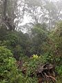
Springbrook National Park rainforest, 2016
-
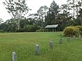
The Settlement picnic area, 2016
-
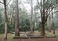
Apple Tree Park, 2016
