Tallebudgera Valley, Queensland facts for kids
Quick facts for kids Tallebudgera ValleyGold Coast, Queensland |
|||||||||||||||
|---|---|---|---|---|---|---|---|---|---|---|---|---|---|---|---|

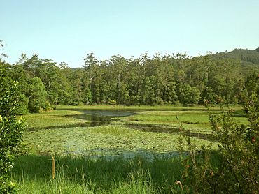
Tallebudgera Creek Dam, 2015
|
|||||||||||||||
| Population | 1,762 (2021 census) | ||||||||||||||
| • Density | 29.32/km2 (75.9/sq mi) | ||||||||||||||
| Postcode(s) | 4228 | ||||||||||||||
| Area | 60.1 km2 (23.2 sq mi) | ||||||||||||||
| Time zone | AEST (UTC+10:00) | ||||||||||||||
| LGA(s) | City of Gold Coast | ||||||||||||||
| State electorate(s) | Mudgeeraba | ||||||||||||||
| Federal Division(s) | McPherson | ||||||||||||||
|
|||||||||||||||
Tallebudgera Valley is a cool place in Queensland, Australia. It's part of the Gold Coast area. This spot is right on the border with New South Wales. In 2021, about 1,762 people called Tallebudgera Valley home.
Inside Tallebudgera Valley, there's also a smaller area called Ingleside.
Contents
Exploring Tallebudgera Valley's Landscape
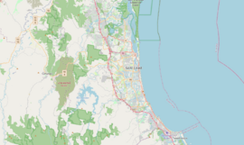
Tallebudgera Valley is located in the beautiful Gold Coast hinterland. This means it's in the hilly, green area behind the famous Gold Coast beaches. It sits right along the border between Queensland and New South Wales.
In the far southwest part of the valley, the land gets very high. It reaches about 800 meters (that's over 2,600 feet!) above sea level. This high area is part of the amazing Springbrook National Park. It's a protected place with lots of nature to explore.
Mountains of Tallebudgera Valley
Tallebudgera Valley is surrounded by several mountains. Here are some of them:
- Bally Mountain (489 meters high)
- Boyds Butte (581 meters high)
- Little Bally Mountain (372 meters high)
- Mount Cougal (715 meters high)
- Mount Cougal (East Peak) (694 meters high)
- Mount Cougal (West Peak) (724 meters high)
- Mount Gannon (633 meters high)
- Tallebudgera Mountain (Durran) (627 meters high)
A Look Back: History of Tallebudgera Valley
This area has a history of schools helping kids learn.
Early Schools in the Valley
- Westbury Provisional School first opened its doors on March 21, 1892.
- It later became Westbury State School in 1909.
- Then, on January 25, 1926, its name changed again to Ingleside State School. This is the school that still exists today!
- Another school, Tallebudgera Upper State School, opened in 1923 but closed around 1942.
Who Lives Here? Population Facts
The number of people living in Tallebudgera Valley has grown over the years.
- In 2011, about 1,557 people lived here.
- Almost half were girls (49.2%) and just over half were boys (50.8%).
- The average age was 43 years old.
- Most people (74.3%) were born in Australia.
- Other countries people came from included England (5.8%) and New Zealand (5.5%).
- Most people (89%) spoke only English at home.
- By 2016, the population grew to 1,624 people.
- In the most recent count in 2021, 1,762 people lived in Tallebudgera Valley.
Learning in Tallebudgera Valley
Kids in Tallebudgera Valley have a great place to learn.
Ingleside State School
- Ingleside State School is a government primary school.
- It teaches students from Prep (the first year of school) up to Year 6.
- Both boys and girls attend this school.
- It's located at 893 Tallebudgera Creek Road.
- In 2017, the school had 109 students. There were 13 teachers helping them learn.
Local Services and Fun Things
The community has some useful services for everyone.
Mobile Library Service
- The Gold Coast City Council offers a special service: a mobile library!
- This library on wheels visits Ingleside State School every two weeks.
- It's a great way for kids and families to borrow books and explore new stories.
 | Misty Copeland |
 | Raven Wilkinson |
 | Debra Austin |
 | Aesha Ash |


