
Springbrook National Park facts for kids
Quick facts for kids Springbrook National ParkQueensland |
|
|---|---|
|
IUCN Category II (National Park)
|
|

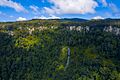
The peaks of Springbrook form the north-eastern remains of the eroded Mount Warning caldera. Mount Cougal and the Gold Coast urban strip can also be seen
|
|

Springbrook National Park
Location in Queensland
|
|
| Nearest town or city | Mudgeeraba |
| Established | 1990 |
| Area | 61.56 km2 (23.8 sq mi) |
| Managing authorities | Queensland Parks and Wildlife Service |
| Website | Springbrook National Park |
| See also | Protected areas of Queensland |
Springbrook National Park is a special protected area in the Gold Coast hinterland of Queensland, Australia. This amazing park covers about 6,197 hectares (that's like 15,313 football fields!). It sits on the McPherson Range, close to the town of Springbrook. It's about 100 kilometers south of Brisbane.
Springbrook National Park is part of the famous Gondwana Rainforests of Australia. This area is so important that UNESCO has listed it as a World Heritage Site. In 1994, UNESCO made the World Heritage Area bigger to include Springbrook and other nearby parks. Later, in 2007, these areas were also added to the Australian National Heritage List. The park is also a special place for birds, called an Important Bird Area, because it helps protect many threatened bird species.
In 2009, Springbrook National Park was named one of the "Q150 Icons" of Queensland. This was part of a celebration of Queensland's 150th birthday. It was chosen because it's such a wonderful "Natural attraction."
Contents
Exploring Mount Cougal Section

The Mount Cougal part of the park is about 20 kilometers inland from Currumbin. It started as a protected area in 1938. Over time, it grew bigger and joined Springbrook National Park in 1990. This section is named after Mount Cougal, which has two peaks. These peaks are called East Peak and West Peak, and they rise 694 meters above sea level. They are right on the border with New South Wales.
The local Yugambeh Aboriginal people have special names for these peaks: Ningeroongun and Barrajanda. They tell a story about a hunter named Gwayla. His two hunting dogs (which were dingos) were killed and buried under the twin peaks. From then on, the peaks were known by their names.
The main place to visit in this section is Cougal's Cascades. This is where the Currumbin Creek begins. There's a road that leads to a car park and a picnic area. From there, you can follow a walking track up the creek to see the cascades. There are no tracks that go up Mount Cougal itself.
Discovering Natural Bridge Section

The Natural Bridge is a cool rock arch that formed naturally over Cave Creek. This creek flows into the Nerang River. The arch was created by a waterfall that slowly carved out a cave underneath it. At the same time, it dug a hole on top. Eventually, the cave and the hole joined, and the creek started flowing through the cave. This left the amazing arch you see today.
The Natural Bridge is in the land of the local Kombumerri Aboriginal people. They are a family group of the Yugambeh language peoples. The first Europeans to find it were said to be timber cutters Alexander Duncan and Din Guinea.

The cave is home to many glow-worms. These are actually the larvae of a type of insect called Arachnocampa flava. They create their own light, which is called bioluminescence. This "living light" helps them attract their prey. You can even go on night tours to see them! To protect the glow-worms, swimming is no longer allowed in the creek near the bridge. You can reach this part of the park from the Nerang-Murwillumbah Road.
Exploring Springbrook Plateau Section
The Springbrook Plateau section has many beautiful waterfalls that you can see on short walks. A popular walk starts at the Tallanbana or Goomoolahra picnic areas. It takes you past Twin Falls, Rainbow Falls, Goomoolahra Falls, and many other smaller waterfalls. The Gwongorella picnic area is where you can start walks to Purlingbrook Falls and Tanninaba Falls.
In all four parts of Springbrook National Park (Springbrook Plateau, Natural Bridge, Numinbah, and Mount Cougal), you can enjoy picnics and explore nature. There are many walking tracks to choose from. The Springbrook Plateau section also has several lookouts where you can enjoy amazing views. You can get to the plateau by a sealed road from Nerang through the Numinbah Valley, or from Mudgeeraba.

The Springbrook Plateau is high up, between 600 and 1,000 meters above sea level. This means it can be quite cool, even in summer. The area gets a lot of rain, usually over 3,000 millimeters a year. Most of this rain falls between December and March. The Natural Bridge section also gets a lot of rain, about 2,500 millimeters annually, mostly during the hot, humid summer.
Natural Environment and Landforms
The southern cliffs in Springbrook are part of what's left of a huge, ancient volcano called the Tweed Volcano. Springbrook National Park is made up of four main areas: Springbrook Plateau, Mount Cougal, Natural Bridge, and Numinbah. The cliffs are made of strong volcanic rock called rhyolite. You can often see rock overhangs, and sometimes huge rocks fall from the cliffs.
The park protects beautiful rainforests and eucalypt forests. These forests are found in the areas where rivers and creeks begin, flowing towards the Gold Coast. The Nerang River and Little Nerang River both flow over the cliffs, creating 16 amazing waterfalls.
Plants of Springbrook National Park

The park has a huge variety of plants because it gets a lot of rain and has different types of volcanic soil. You'll find Subtropical rainforest with trees like black and white booyong on rich basaltic soils. On poorer rhyolitic soils, you'll see warm temperate rainforest with trees like coachwood. Giant brush box trees grow to the east of the plateau, and flooded gums are also found in basalt areas.
There's even a small area of cool temperate rainforest with very old Antarctic beech trees. Some of these trees are 3,000 years old! A special tree called the Springbrook leatherwood was only discovered in 1993. It grows up to 25 meters tall and is only found in the warm temperate rainforests of Springbrook.
Other areas that are more likely to have fires have open forests with trees like New England blackbutt and Blue Mountains ash. You'll also commonly see grasstrees. Rocky areas have montane heath or shrubland with plants like Leptospermum variable and Banksia spinulosa. These heath areas are especially pretty in spring when many wildflowers bloom.
Animals of Springbrook National Park

Springbrook National Park is a great place to spot animals that come out at night. You might see the mountain brushtail possum, the ringtail possum, and the sugar glider. Because a lot of land around the park has been cleared, Springbrook has become a safe home for many birds. More than a hundred different bird species live here, including the yellow-tailed black cockatoo, rufous fantail, satin bowerbird, and the Albert's lyrebird.
Long-finned eels are often found in the park's pools. There are also many reptiles, like the land mullet, which is the world's largest type of skink, and the lace monitor. You can also find amphibians like the orange-eyed treefrog and the great barred frog. Rare creatures like the Richmond birdwing butterfly, blue spiny crayfish, and glow-worms (which are larvae of the fungus fly) also live in the park. You might even see Red-necked pademelons and koalas!
Recreation and Camping
You are not allowed to camp in the bush at Springbrook National Park. However, there is one camping area available on Carricks Road.
Images for kids
-
Twin Falls Waterfall seen from the start of the Twin Falls Circuit trail
-
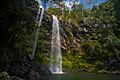
Bottom of the Twin Falls Circuit


See also
 In Spanish: Parque nacional Springbrook para niños
