Nerang, Queensland facts for kids
Quick facts for kids NerangGold Coast, Queensland |
|||||||||||||||
|---|---|---|---|---|---|---|---|---|---|---|---|---|---|---|---|

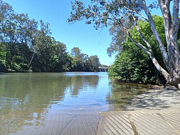
Nerang boat ramp at Arthur Earle Park
|
|||||||||||||||
| Population | 17,048 (2021 census) | ||||||||||||||
| • Density | 474.9/km2 (1,230/sq mi) | ||||||||||||||
| Postcode(s) | 4211 | ||||||||||||||
| Elevation | 11 m (36 ft) | ||||||||||||||
| Area | 35.9 km2 (13.9 sq mi) | ||||||||||||||
| Time zone | AEST (UTC+10:00) | ||||||||||||||
| Location |
|
||||||||||||||
| LGA(s) | City of Gold Coast | ||||||||||||||
| State electorate(s) | Gaven | ||||||||||||||
| Federal Division(s) | |||||||||||||||
|
|||||||||||||||
Nerang is a town and suburb located in the City of Gold Coast, Queensland, Australia. It's a busy place with a mix of homes, shops, and businesses. In 2021, about 17,048 people lived in Nerang.
Contents
Nerang's Location and Features
The Nerang River flows right through the area. It starts in the south and moves towards the east, passing through the town. This river eventually reaches the southern part of Moreton Bay.
Nerang has a small town centre. Here you can find banks and many other shops and services. There are also several industrial parks. These parks are home to different types of businesses. They offer services like car repairs, printing, and equipment hire. The local Gold Coast City Council offices are also in Nerang. They handle things like town planning and building permits.
A Look Back at Nerang's History
Early Days and Name Meaning
The name Nerang comes from the river. It's believed to be a word from the Yugambeh language. It might mean small river or shovel nosed shark in the Bundjalung language. Before British settlers arrived, the area was home to the Kombumerri clan and the Wanggeriburra clan. These groups are part of the Yugambeh people. In the 1850s, the Aboriginal population in the area faced difficult times.
How Nerang Grew
Nerang was officially mapped out in June 1865. Streets were named after important early settlers. The town grew around the river crossing. Land was first sold here in 1871. Around the same time, Cobb & Co coaches started daily services from Brisbane. River transport also became more regular.
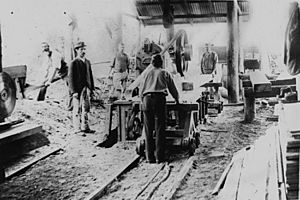
The first hotel, The Nerang, opened in 1872. Soon, other hotels followed as more people visited. The first big industry in the area was timber cutting. There was a lot of red cedar and other trees.
Nerang State School opened its doors on 1 November 1875. It started with 47 students. As more businesses like stores, a butcher, and a baker opened, Nerang really started to feel like a town. By 1881, 95 people lived there.
By 1888, Nerang had three schools. The population grew to 343 by 1901. By 1905, Nerang was becoming known for dairying. Farmers also grew maize, arrowroot, and potatoes.
Railways and Roads
In the 19th century, the Gold Coast area was mostly farmland. Farmers grew sugar and maize along the Nerang River. Nerang was an important town for these farming activities. The South Coast railway reached Nerang in 1887. This railway helped connect the farming towns. It also helped them grow.
In 1927, a timber building was built specifically for the Nerang Council Chambers. During World War II, the Australian Army used Nerang as a tank training centre.
The Shire of Nerang became part of the Shire of Albert in 1950. The old Council Chambers then became a post office.
In the mid-20th century, the beaches of the South Coast became popular for holidays. This led to the area being called the Gold Coast. Tourism then became the main industry.
The Gaven Way highway opened in 1960. This road connected the Pacific Highway to Nerang. It was the first part of the Pacific Motorway in Queensland. It helped divert traffic away from the busy coastal holiday areas.
The South Coast railway and the old Nerang railway station closed in 1964. More people were using cars, and farming became less important. The Pacific Motorway later followed much of the old railway route. The Nerang town centre was bypassed by the motorway in 1979.
Nerang State High School opened on 28 January 1986. St Brigid's Catholic Primary School opened in 1994.
In the 1990s, the Gold Coast needed a new railway. The Gold Coast railway line reached Nerang in 1997. The new Nerang railway station is in a different spot than the old one. This new railway helps workers and tourists travel between the Gold Coast and Brisbane. It also connects to Brisbane Airport.
Nerang has changed from a farming service centre to a residential suburb. Many people who live here work in the coastal tourism industries. In 2003, Nerang was officially called a suburb instead of just a locality. Today, Nerang is an important administrative centre for the growing Gold Coast.
The Nerang public library opened in 2003.
Population Information
Nerang has grown steadily over the years:
- In 2011, the population was 16,256 people.
- In 2016, it grew to 16,864 people.
- In 2021, the population reached 17,048 people.
Getting Around Nerang
Nerang is a key transport hub. It has several shopping centres and the Nerang railway station. This makes it easy to get around and access services.
Schools in Nerang
- Nerang State School is a primary school for students from Prep to Year 6. It is located at 3 Nerang Street. In 2018, it had 325 students.
- St Brigid's Catholic Primary School is also a primary school for Prep to Year 6. It is located at 39-49 McLaren Road. In 2018, it had 406 students.
- Nerang State High School is a secondary school for students from Year 7 to Year 12. It is located on Weedons Road. In 2018, it had 1026 students. All three schools offer special education programs.
Community Places
- The Nerang Branch Library is on the corner of White & Price Streets. It also has a special collection for people with developmental and disability needs.
- The Nerang branch of the Queensland Country Women's Association meets at the Girl Guide Hut at 40 Ferry Street.
Sports and Fun in Nerang
Nerang is home to several sports teams:
- The Nerang Roosters are the local rugby league club.
- The Nerang Bulls RUC are the local Rugby Union club. They play their home games at Robert Dalley Park.
- The Carrara Sports Ground is close by. Metricon Stadium, home of the Gold Coast Suns AFL football team, is also there. This area was developed for the 2018 Commonwealth Games.
Nerang also has a velodrome for cycling. There's a public swimming pool complex with three pools and a splash area for younger kids. The Mudgeeraba/Nerang Cricket Club plays at Carrara. They have teams for all ages, from juniors to first grade. You can also find many world-class golf courses nearby. The Nerang area includes beautiful places like Springbrook, Natural Arch, and Lower Beechmont. These are great for picnics, horse riding, and bush walking.
Historic Sites in Nerang
There are several places in Nerang that are listed as heritage sites:
- Nerang Police Lock-up (Old Nerang Gaol) at 68 Billabirra Crescent (Country Paradise Parklands).
- Maid of Sker at 48 Nerang Street (Bischof Pioneer Park).
- Ceramic House at 48 Nerang Street (Bischof Pioneer Park).
- Preece House at 48 Nerang Street (Bischof Pioneer Park).
- Nerang Hall (formerly Nerang School of Arts) at 34 Price Street.
Some buildings were moved from Nerang:
- St Margaret's Church (originally in Nerang) is now at 135 Bundall Road, Surfers Paradise (Surfers Paradise Administration Centre).
Famous People from Nerang
- Sara Carrigan - She won a gold medal in road bicycle racing at the 2004 Summer Olympics in Athens.
- Billy Drumley - An important Indigenous community leader.
- Sydney Barber Josiah Skertchly (1850 – 1926) - A botanist and geologist who is buried in the local cemetery.
- Reece Walsh - A current player for the Brisbane Broncos and a Queensland State of Origin representative. He grew up in Nerang and played junior rugby league for the Nerang Roosters.
 | Anna J. Cooper |
 | Mary McLeod Bethune |
 | Lillie Mae Bradford |


