
Nerang River facts for kids
Quick facts for kids Nerang |
|
|---|---|

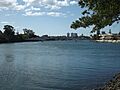
View south at Surfers Paradise, 2007
|
|

Location of the Nerang River mouth in Queensland
|
|
| Country | Australia |
| State | Queensland |
| Region | South East Queensland |
| Local government area | City of Gold Coast |
| City | Southport |
| Physical characteristics | |
| Main source | McPherson Range Numinbah Valley 138 m (453 ft) 28°14′34″S 153°15′15″E / 28.24278°S 153.25417°E |
| River mouth | Gold Coast Broadwater Southport 0 m (0 ft) 27°58′32″S 153°25′21″E / 27.9756°S 153.4225°E |
| Length | 62 km (39 mi) |
| Basin features | |
| Basin size | 490 km2 (190 sq mi) |
| Tributaries |
|
| National park | Springbrook National Park |
The Nerang River is a river in South East Queensland, Australia. It flows through the Gold Coast area. The river is about 62 kilometers (38 miles) long. Its catchment area covers 490 square kilometers (189 square miles).
Contents
River's Journey and Features
The Nerang River starts in the McPherson Range mountains. This is near the border of New South Wales and Queensland. It flows north, then east, passing through the town of Nerang. Finally, it reaches its mouth in the Gold Coast Broadwater at Southport. From there, it empties into the Coral Sea. The river drops 255 meters (837 feet) over its 62-kilometer (38-mile) course.
Important roads cross the river. The Pacific Motorway crosses it at Nerang. The Gold Coast Highway crosses it at Southport.
The Nerang River system is the biggest and most important on the Gold Coast. Its upper parts are in the McPherson Range and Springbrook Plateau. Water from here flows through farms and into the Hinze Dam. This dam creates Advancetown Lake, which is the Gold Coast's main water supply. The Little Nerang Dam also helps supply water. These dams provide a lot of drinking water for the Gold Coast. They also help control floods.
In the lower part of the river, there are many canal developments. These are like man-made waterways. There are also artificial lakes. These changes have affected the natural floodplains. The canals are great for residents who enjoy boating and fishing. They also provide homes for many water animals, land animals, and plants. The canals help drain stormwater and prevent floods. However, they can sometimes get polluted by stormwater.
There are several islands in the canal area of the lower river. These include Girung, Paradise, Chevron, Cronin, and McIntosh Islands. There are also two man-made lakes: Lake Rosser and Lake Capabella.
The river's mouth used to be much further south. In the early 1800s, it entered the ocean at Broadbeach. By 1930, its mouth was where Sea World is now. This movement happened because of the northward drift of sand along the coast.
What's in a Name?


When government surveyor Robert Dixon mapped the Gold Coast in 1840, he first named the river the River Barrow. He named it after Sir John Barrow. Later, the surveyor general Thomas Mitchell changed many place names to Aboriginal names. This is how the river got its current name, Nerang.
The words Neerang or neerung come from the Yugambeh language. They mean "little shark" or "shovel-nosed shark." However, the local Aboriginal people had other names for the river, like Mogumbin or Been-goor-abee. People from the Tweed area called it Talgai.
Fun Activities and Recreation


Surfers Riverwalk
The City of Gold Coast Council is thinking about improving the Surfers Riverwalk. This is a path along the river. It would connect the Gold Coast Highway Bridge at Main Beach to the Pacific Fair Shopping Centre at Broadbeach. The path would go along many interesting places, including:
- The western beaches of Main Beach
- The shores of McIntosh Island
- Jaraparilla Cove
- The Marriott Hotel boardwalk
- Budds Beach
- The Surfers Central Riverwalk, from Budds Beach to Lionel Perry Park
- The Paradise Island area
- Cannes Avenue Reach of the Nerang River
- Cascade Gardens shores of Little Tallebudgera Creek
- Gold Coast Convention & Exhibition Centre boardwalk
- The Star Gold Coast Island shores
- Pacific Fair Shopping Centre
Boat Ramps
If you want to launch a boat, there are public boat ramps. You can find them at Waterways Drive at Main Beach, Budds Beach, Evandale, on the Isle of Capri, TE Peters Drive at Broadbeach Waters (near the Convention Centre), Carrara Road in Carrara, and at the Nerang River Parklands.
Nerang Riverkeepers Group
The Nerang Riverkeepers Group started in 2000. They are part of a program called "Beaches to Bushland Volunteer restoration." This group works to bring back native plants along the Nerang River.
One big project they work on is controlling a plant called cats claw creeper. This plant is a serious weed in Australia. It originally came from Central and South America and the West Indies. It was first seen growing wild in Australia in the 1950s. Its seeds spread easily by wind or water. This woody vine grows over native forests and can kill native trees and smaller plants. Even if you cut it down, it can grow back from its roots underground.
Images for kids
-
Thomas Drive bridge over Nerang River, Southport, Queensland
-
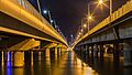
Sundale Bridge over the Nerang River, Queensland
-
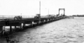
Jubilee Bridge, Southport, around 1932 (removed in 1966)


