Numinbah Valley facts for kids
Quick facts for kids Numinbah ValleyGold Coast, Queensland |
|||||||||||||||
|---|---|---|---|---|---|---|---|---|---|---|---|---|---|---|---|

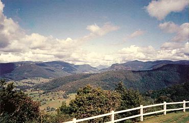
Numinbah Valley from Rosin's Lookout
|
|||||||||||||||
| Population | 212 (2021 census) | ||||||||||||||
| • Density | 3.636/km2 (9.42/sq mi) | ||||||||||||||
| Established | 1880 | ||||||||||||||
| Postcode(s) | 4211 | ||||||||||||||
| Area | 58.3 km2 (22.5 sq mi) | ||||||||||||||
| Time zone | AEST (UTC+10:00) | ||||||||||||||
| Location |
|
||||||||||||||
| LGA(s) | City of Gold Coast | ||||||||||||||
| State electorate(s) | Mudgeeraba | ||||||||||||||
| Federal Division(s) | McPherson | ||||||||||||||
|
|||||||||||||||
Numinbah Valley is a beautiful rural area located in the Gold Coast region of Queensland, Australia. It's a special place known for its stunning natural scenery, including valleys, waterfalls, and rainforests. In 2021, about 212 people lived here.
Contents
Exploring Numinbah Valley's Geography
Numinbah Valley is a large valley in the Gold Coast hinterland, which is the area behind the coastal cities. It covers about 116 square kilometers. You can find open areas for grazing animals, cool rocky spots, amazing waterfalls, and lush rainforests perfect for walks. Many people think it's one of the most beautiful valleys in South East Queensland!
Unlike some other parts of the Gold Coast, Numinbah Valley has stayed pretty natural and hasn't been built up much. To the east, you'll find the Springbrook plateau, home to the famous Natural Bridge in Springbrook National Park. To the west are the Lamington Plateau and Lamington National Park. South of the valley is the Tweed Valley in New South Wales.
The valley is filled with different types of forests, from dry to wet. The Nerang River starts in this valley and flows into the Hinze Dam, which is in the northern part of the valley. Small communities like Advancetown and the tiny town of Numinbah are also found here.
Amazing Wildlife: The Platypus
The rivers and streams in Numinbah Valley are a special home for the duck-billed platypus. These unique animals are often seen in places like Bonchow Park and Forest Park. Recent studies show that a large number of platypuses on the Gold Coast live in the fresh water streams of Numinbah Valley and nearby areas like Canungra.
Roads and Travel
The main road that runs through the valley from north to south is the Nerang–Murwillumbah Road. This road helps people travel through this scenic area.
A Look at Numinbah Valley's History
The Numinbah Valley was first explored by people looking for cedar trees in 1845. These timber cutters used strong bullocks to pull the cut wood to Nerang. Later, in the 1860s, a path to the Tweed Valley was found when surveyors were mapping the border between Queensland and New South Wales. This led to more settlers moving into the area.
A small town began to grow in the 1880s. A sawmill, which cuts timber, operated in the valley from 1909 until 1944. After that, farming and dairy production became the main ways people made a living.
Numinbah Provisional School first opened its doors on February 7, 1927. In 1938, it became known as Numinbah Valley State School.
People and Community
In 2016, Numinbah Valley had a population of 218 people. By 2021, the population was 212 people.
A local group called the Numinbah Valley Landcare group works to protect and care for the environment in the valley.
Local Facilities and Activities
What the Economy Offers
One interesting fact about Numinbah Valley is that a special material called perlite is dug out from a deposit here. Perlite is a type of volcanic glass, and it's then transported to Sydney for various uses.
Important Buildings and Centres
The Numinbah Correctional Centre is located within this area.
Learning and Education

Numinbah Valley State School is a government primary school for students from Prep to Year 6. It's located at 2270 Nerang-Murwillumbah Road. In 2017, the school had 14 students.
There's also the Numinbah Valley Environmental Education Centre. This centre is a great place for outdoor and environmental learning. It's located at 1721 Nerang-Murwillumbah Road.
If students need to go to secondary school, the closest one is Nerang State High School in Nerang.
Fun Things to Do and See
The Gold Coast Hinterland Great Walk is a long walking trail that goes right through the valley. It stretches from O'Reilly's Guesthouse in the west to Springbrook National Park in the east. It's a fantastic way to explore the natural beauty of the area.
Bornhoffen PCYC and the Numinbah Valley Environmental Education Centre are large places that host groups of students. These centres are located in the southern part of the valley, where the Nerang River begins. They offer many recreational activities and learning experiences.
Important Historical Places
Numinbah Valley has some special places that are listed as heritage sites. This means they are important historical locations that are protected. These include:
- 365 Chesters Road: The Banana Packing Shed
- 2136 Nerang Murwillumbah Road: The Numinbah Valley School of Arts
 | DeHart Hubbard |
 | Wilma Rudolph |
 | Jesse Owens |
 | Jackie Joyner-Kersee |
 | Major Taylor |


